Monday, October 1, 2018

Cedar Rock Mountain of DuPont

I see them on my Instagram feed constantly – the gorgeous shots taken from atop the world in spots like Max Patch, Clingmans Dome, Graveyard Fields, Sam’s Knob. What many of these places have in common is that they are mountain summits/crests covered primarily by thick vegetation of native grasses or shrubs (instead of forest growth), providing the Insta-worthy views. Known as balds, these scenic peaks occur at high elevations in the Appalachian Mountains in places where the climate is too warm to support an alpine zone (where trees can’t grow due to short or non-existent growing seasons), but instead are a result of heavy drainage or highly acidic soils, which complicate the growth of trees.


However, the balds of the Nantahalas, Great Smoky Mountains and Blue Ridge Mountains are more than a couple hours’ drive from Greenville, and so are out of range for a casual day trip. Not so for another type of ‘bald’ that is more common in South Carolina – the granite outcrop. One of the most familiar is Bald Rock Heritage Preserve, a complex of granite outcrops with a view of the Upstate including Paris Mountain and Greenville. Another spot is Glassy Mountain in Pickens, with multiple exposed-rock areas along the 1.5 mile trail.


The “flat-rock granite outcrops” are composed of unbroken granite and granite-gneisses, and are implaced within Precambrian metamorphic rocks which are scattered on the eastern side of the Appalachian Mountains. These formations have been exposed due to the combination of uplift and erosion, and provide unobstructed, scenic views due to lack of trees – trees don’t grow on rock. Just over an hour from Greenville in the DuPont State Forest is an area with some of the most exposed granite in the region – Cedar Rock Mountain. Rising only 200′ feet above the surrounding plateau, hundreds of acres alternate between bare and moss/lichen covered rock.


The moderate, 2-mile round-trip hike to the summit of Cedar Rock Mountain on Big Rock trail rewards visitors with far-ranging views west, as well as a look at some of the interesting plant communities that call the granite outcrop home. A reminder to visitors to please stay off moss; the lichens, moss and other plants that eke out their existence on the bare rock are ultra-sensitive to human traffic.


To reach Cedar Rock Mountain, park at the Corn Mill Shoals Access Area of DuPont Forest and proceed on Corm Mill Shoals Trail on the east side of the road. Keep going past Longside Trail, and then take a left on Big Rock Trail. The trail heads steadily upward, crossing a small granite clearing and then emerging onto a large granite dome that looks over the Pisgahs. The view here is fantastic, but keep going up to the summit and through a forested segment to reach another granite area that is used as a helispot by the Forest Service. The coloring of the granite is fascinating, with Here is the intersection with Cedar Rock Trail, which forms a loop when combined with a section of Little River Trail (altogether about 4 miles from Corm Mill Shoals Access).


Peak fall color for DuPont and area is forecast to be mid-October until late October by Appalachian State University and the Smoky Mountains Fall Foliage Prediction Map. While the foliage will not be as brightly hued as further north on the Blue Ridge Parkway (due to the high percentage of softwoods interspersed with the hardwoods), the views of the Pisgah Mountains are dramatic nonetheless, making this a perfect fall hike within easy driving distance of the Upstate.


For my post on DuPont’s waterfalls, please see my post here. A map of DuPont State Recreational Forest can be found here for download, although for extensive hiking/biking/riding I would suggest picking up one of the waterproof/tear-proof topo maps from the DuPont Visitor Centers or Amazon.com.


Monday, September 24, 2018

The Rapids of Chau Ram County Park

The beauty of the South Carolina State Parks is no secret, nor is it a surprise that they can get quite crowded on occasion… The number of visitors on some weekends is so high that it’s one in for every one car out (such as at Jones Gap), or you get cars parking on the sides of curvy mountain roads (Caesars Head). While some measures are being taken to alleviate the stress of increased usage (including expanding parking areas and even purchasing additional acreage), we enjoy heading to lesser known areas now and then for a more solitary experience. The newest park to be added to this list is Chau Ram County Park.

Canopener rapid

Located west of Westminster on 200 acres along the Chauga River, the park is managed by Oconee County Parks, Recreation and Tourism. It takes just over an hour to get there from Greenville, but the drive is worth it as it’s easy to spend an entire day on the river and trails. To extend your visit, book one of the 26 campsites with water and electricity, or reserve a picnic shelter or the recreation building for a larger event. However, there are multiple picnic areas that are first come, first serve, so bring a picnic and plan on staying a while!

Map of Chau Ram County Park

Chau Ram is named for its location at the confluence of the Chauga River and Ramsey Creek. Park in the lower of the two parking areas adjacent to the rec building and office, and you’re just feet away from Ramsey Creek and right at the base of Ramsey Creek Falls. The creek cascades 30-40ft over large builders on its way to the Chauga, a large granite outcrop serving as an ideal picnic space if the nearby picnic shelters are occupied.

Ramsey Creek Falls, also known as Chau Ram Falls

Crossing a small bridge over Ramsey Creek will take you to additional picnic areas, Upper and Lower Falls Trail, and the beach area on the Chauga. The sandy area is shallow with easy access, allowing an alternative to playing in the deeper, faster-moving waters up and down the river.

Looking upstream from the bridge, beach to left and pump house visible in distance

There are five sets of rapids on the Chauga River which are accessible by the 4-mile network of trails and the 175 foot pedestrian suspension bridge over the river. The bridge is the longest of its kind in the County, and is easily set in motion while it’s being crossed – the kids definitely liked the swinging more than the parents!

Chau Ram suspension bridge

The trails criss-cross the west bank of the Chauga, with the orange trail creating a loop to the south, the blue trail creating a loop to the north, and the red trails extending from the primitive camp site in the middle to the scout cabin and north to the blue trail. To hike a 1.5 mile loop that passes all the rapids, head north on the orange, then blue trail, and follow it along the Chauga until you can see the Long Creek Highway bridge. Climb the stairs and continue on the blue trail until you reach the primitive camp site; just past that turn south on the orange trail to return to the Chauga River, returning to the suspension bridge along the river.

Hiking in this direction you’ll first come to Pump House Rapids, named for the pump house across the river. The noise from the pumps is ever-present, although it is interesting to see how the City of Westminster uses the river as a water-intake area.

Pump House Rapids on the Chauga River

The narrow trail continues along the river, and late summer and early autumn we paid extra attention to the poison ivy that seems ever-present in this region and in some spots reached out over the trail. Soon we reached Lost Paddle Rapids, where summer weekends you can watch kayakers navigating the rocky waters, and imagine how the rapids got its name.

Lost Paddle Rapid on Chauga River

Not too much further is Jump Off Rock (although on our recent visit there wasn’t going to be any jumping as the water was too low), and then soon after the Double Red Trail splits off towards the Primitive Camp Site area we began to hear the sound of traffic. Just when Long Creek Highway comes into view, the trail takes a sharp turn, climbs up several flights of stairs, and then heads steadily south along the park boundary.


After the Primitive Camp site you’ll reach a four way intersection. Going north on the Red Trail takes you to the Scout Cabin and the Double Red Trail, continuing east on the Blue Trail takes you back to the Suspension Bridge and Pump House Rapids, and turning right on the Orange Trail takes you on a steep descent south to Morgans Rock and the V Rapids. There is a short spur trial (the White Trail) that goes a few hundred feed further to the west, but at this point the Orange Trail turns east along the Chauga.

V Rapids on Chauga River

My favorite spot in the park is Canopener Rapids, about halfway from the V Rapids back to the bridge. The large, flat rock is ideal for a picnic, or to just spend a moment next to the water as it cascades down the boulders on its way to the South Carolina/Georgia border. The headwaters of the Chauga are up west of Oconee State Park; from there the river passes through the Chauga Narrows, forms the Chauga Scenic River area that is extremely popular with anglers, and runs over Riley Moore Falls before hitting the five sets of rapids at Chau Ram and continuing south.

#DestinationOconee #ChauRamPark

This corner of South Carolina is wild & scenic, with the Sumter National Forest to the northeast, dozens of waterfalls including Yellow Branch and Brasstown Falls, Stumphouse Tunnel, and the (officially) Wild & Scenic Chattooga River all within relatively short driving distance. But why hurry on, as you’ve got everything right here in Chau Ram County Park…


Chau Ram County Park is open from March 1 through November 11th and admission is $2/car. Click here to book a campsite, and here for the Oconee County Parks, Recreation & Tourism Chau Ram facebook page.

Wednesday, September 19, 2018

Musings on Hurricane Florence

How is everyone doing out there? Hopefully everyone is dry and the power’s on…

Just a little update from our corner of the Upstate… A little bit of wind (gusts up to 30mph), a little bit of rain (less than 2 inches). Power went out twice – once Friday, once Sunday – but Florence’s route directly over Greenville meant we were never in her northeast quadrant, and were spared the heavy rains the NE corner of the state received. You can see who got what here.

Blue skies and hot temps Friday at Chau Ram County Park

The most interesting weather actually came through on Friday, which we spent up in Oconee county in some soupy summer weather. As you can see in this video from our local Stone Academy weatherSTEM station, sunrise and sunset were crazy colorful. Add to that clouds moving in two different directions at once all day, and you have some prime sky-watching material.


The rainy weather meant curling up with a good book, and I’ve got two that merit mention here. The first, Karl, Get Out of the Garden!: Carolus Linnaeus and the Naming of Everything by Anita Sanchez is actually a children’s book, but it was read and enjoyed by 3 out of 5 household members. The beautifully-illustrated book is about scientific names and the Linnaean system (the basis for the classification system used by biologists around the world today), but backyard science is brought to life for the budding naturalist, scientist and botanist.


The second book was a completely unexpected. Despite (or maybe I should write in spite of) Florence, cookbook club persevered, and Sunday evening we gathered for a feast of hurricane proportions. This month’s book was The Cottage Kitchen: Cozy Cooking in the English Countryside by Marte Marie Forsberg. I’m not sure if it is because of the heavy Scandinavian undertones, the accessible ingredients, or the gourmet dishes requiring (surprisingly) little effort, I made a record number of recipes from this cookbook in the weeks preceding our Sunday dinner and loved every single one of them. I enjoy a cookbook divided by season, and with the high temperature/humidity days it’s no surprise I was cooking out of the ‘summer’ chapter… Tomato tarte tatin with burrata, Tomato, olive, and mozzarella baked peppers, Spinach and goat cheese frittata… Thank goodness fall is around the corner as I’ll be able to try the Potato soup with smoked salmon, then come winter I’ll repeat the Warm salmon, mint and potato salad, and Creamy fish soup with clams. However, don’t discount the ‘afternoon tea’ section – Lise’s carrot cake and Tante Marie’s coffee and fig bread among others – which is absolutely delicious. If I could suggest a Femme au Foyer cookbook of the year, this would be it. (Disclaimer, the first edition was actually published in 2017, but let’s not bandy words…)

The Cottage Kitchen's tomato tarte tatin with burrata

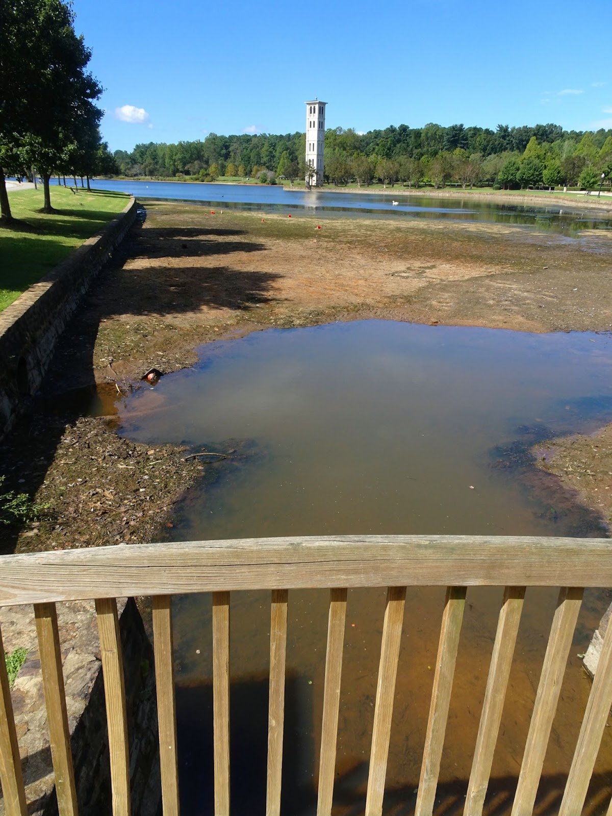
But back to Florence, what I find interesting is that despite the massive rainfall received in portions of the state, South Carolina is barely out of drought status. According to the National Integrated Drought Information System, the portion of the state that received the most rainfall in the past week was actually suffering from abnormally dry conditions just last week. Greenville County had been in a moderate drought up until June 2017, and although we’re now at ‘normal’ levels, it’s clear from the lake levels that it will take a little more to bring us back up to speed. Remember, some of the worst flooding in SC has been from rivers cresting – the same rivers that receive all the runoff water from the impervious surfaces and channeled rivers & creeks here in the Upstate.

On the 1.5 mile trail around Lake Furman - the lake level is LOW

Thinking of all those who had more than their share of this massive storm, and keeping a careful eye on the Atlantic during the next two months of hurricane season,

x your Femme au foyer

Friday, September 14, 2018

Huntington Beach and Atalaya

With Hurricane Florence bearing down on the Carolinas, I thought I would pay homage to an iconic coastal state park and the most recent of our coastal South Carolina adventures - Huntington Beach State Park. Huntington Beach (along with others including Myrtle Beach, Edisto Beach and Charles Towne Landing) has been closed until further notice due to mandatory hurricane evacuation orders. There is some irony in that our Labor Day trip was the result of two previous hurricanes; it was after Hurricane Hugo that the south campground was abandoned, but this year 42 new full-service campsites were added to this southern-most point of the park, and we were invited to take a look for ourselves. Hurricane Matthew changed our initial plans, but a few weeks ago we packed up and headed to the coast to enjoy the last bit of summer in what had been a relatively hurricane-free season so far. Now we are holding our breath while Mother Nature does her thing…

The Atalaya inner courtyard and watchtower at Huntington Island State Park

Although just 15 miles south of Myrtle Beach State Park, Huntington Beach couldn’t be further from Myrtle in style. The quiet, near empty beaches are just as appealing, even more so if you don’t fancy setting up your beach umbrella inches away from the next family. Book a site in one of the campgrounds and enjoy beach access away from the hustle and bustle at the public beach access points; even on our Labor Day weekend visit we virtually had the beach to ourselves.


A great starting point is the Park Office. The building also houses camper registration and the gift shop; this is the place to pick up ice for your coolers, wood for the evening’s campfire, and get that park stamp in your Ultimate Outsider book. They’ll also have info on the week’s programs, which during our stay included a snakes and reptiles program, crabbing catch and release, hikes with rangers, and guided tours of Atalaya.


This National Historic Landmark home of Archer and Anna Hyatt Huntington is located between the South Beach Access and South Campground. Take a self-guided audio tour or a ranger-led tour of the picturesque, Moorish-style home that was the winter retreat of the renowned 20th-century sculptor. Named ‘Atalaya,’ a Spanish term for watchtower, the house was designed after the Moorish architecture of the Spanish Mediterranean Coast. From the fascinating, square form of the outer walls to the grassy inner courtyards; from the 40ft tall watchtower (which actually was the water tower) in the center to the bear pen for Anna Huntington’s ursine models – Atalaya is a picturesque refuge that has withstood many hurricane-force winds. In tribute to Mrs. Huntington, the annual Atalaya Arts and Crafts Festival is held in the Castle next week, during what annually is the fourth weekend of September; stay tuned to the SC State Parks website for more info how this might be affected by Hurricane Florence.

The Atalaya grillwork was designed by Anna Huntington

Archer Huntington designed Atalaya, but Anna’s influence is everywhere – from the grillwork she designed for the windows, to the spacious indoor/outdoor studios and the facilities to host the animals she traveled with. Locally hired workers alternated between construction on Atalaya and Brookgreen Gardens (just next door) in the early 1930s, and the home was used up until Mr. Huntington’s death in 1955. Admission is $2/person, but the really adventurous can wait until early November when guests can spend the night in Atalaya, complete with ghost stories by the campfire, nighttime beach walks and dinner/breakfast (for pricing and more info see Huntington Beach official website).

Watching it rain over the ocean

The east side of Atalaya faced the ocean and the pristine Grand Strand beach, although today the view is of scrub and maritime forest. However, the surrounding area has always been well known to birders, who for years have been coming to see some of the more than 300 species that have been recorded in the park. Visitors looking to spot wildlife will want to check out one of the four trails within the Park, the best known of which might be the Atalaya Straight Road; the 0.5 mile trail leads directly from Atalaya west between Mallard Pond and Mullet Pond. Between 3 to 7pm it is common to see alligators moving between the ponds, but sightings aren’t restricted by the clock; on our visit we spotted a giant gator hanging out near the trail in the early afternoon. Reptiles, birds, spiders and wildlife galore – bring binoculars, pick up a bird list at the Park Office, and heed the warnings to stay on the trail!

A snowy egret and a roseate spoonbill in Mullet Pond

The three miles of beach can be easily accessed from the South and North Beach Access points, as well as from the campgrounds. Beachcombers will enjoy hiking along the beach another 1.2 miles up from the north access to the very northern tip of the Park and the jetty, passing through the bird sanctuary and enjoying the ocean breeze. We hit the beach at different times of day, and each time had a slightly different experience. With low tide we dug up mole crabs and watched them burrow back in. High tide brought with it a shark’s tooth for Lauris to find. While the morning meant an almost-empty beach and cooler temperatures, dusk/twilight was perfect for hunting sand crabs. Even during the heat of the day we saw numerous birds, crabs and even jellyfish (yes, jellyfish, so careful in the water).

Even crabs need love

If you want to see dozens of crabs without the effort of chasing after them on the beach, try walking out on one of the two boardwalks over the marsh. Much of the park is salt marsh, one of the world’s most productive eco-systems. The 1/4-mile Kerrigan Trail and the 0.1 mile Boardwalk extend out into the saltmarsh and freshwater lagoon for exceptional wildlife viewing; visitors may spot pelicans and alligators, as well as catching rare glimpses of nesting loggerhead sea turtles and roseate spoonbills. There is a parking area at the first intersection after entering the Park/admissions and driving across the causeway; it gives access to the walkways and viewing points along the causeway, with frequent alligator sightings as well as excellent birdwatching almost any time of day.

We saw these baby alligators near Mullet Pond, but the 8ft giant was in Mallard Pond

Florence isn’t the first hurricane to come ashore on the beaches of the Carolina, nor is it likely to be the last. While we wait to see what the results of Hurricane Florence will be, please stay safe. Heed evacuation warnings, don’t drive into water, and be mindful of downed wires. Our beaches are ever-shifting, and hurricanes, while significantly affecting our coastline, are a natural occurrence; time will tell what Florence does with the Carolinas.


*** Sculpture by Anna Huntington can be found in nearby Brookgreen Gardens, or if you are in the Upstate, visit Andrew Jackson State Park to see her piece Boy of the Waxhaws. For my first post on Huntington Beach State Park, click here.

Wednesday, September 12, 2018

Music in the Woods

The beginning of September heralds the return of the Music in the Woods series in Greenville’s closest state park, Paris Mountain. Every Saturday afternoon from 2 - 4 pm through October, local bands perform in the outdoor amphitheater courtesy of Paris Mountain State Park Friends and the South Carolina Park Service. The concert is free with park admission, and in my opinion is the most undervalued free concert series in the Upstate!


The series kicked off with Nikki Talley on September 1st and the Trapfire Brothers this past Saturday. Next up, My Girl, My Whiskey and Me this weekend on the 15th, Gwyn Flower September 22nd, and Local Green Family Band to round out September on the 29th. October has Dave Desmelik on the 6th, Swamp Rabbit Railroad on the 13th, The Passing Scene on the 20th, and a local favorite, Darby Wilcox on the 27th. You can follow the series on facebook here.


To reach the amphitheater, park in the main parking lot across from the Park Center. From there it is a short walk on Mountain Creek Trail – follow the signs to the amphitheater. Concert-goers are welcome to bring their dinner, cooler and pets (on a leash), and the kids usually run around while the music is playing, exploring the surrounding woods.


These concerts are eco-friendly, using solar power to generate electricity for the bands. Part of the amphitheater is always in the shade of the surrounding trees, but if it rains, the closest shelter is the bicycle repair station up near the Park Center so you might want to pack an umbrella if there is a chance of afternoon showers.


Before or after the concert: hit one of the Paris Mountain Trails, admire the Civilian Conservation Corps era Park Center, or swim/paddle out on Lake Placid. And don’t forget to get your stamp if you’re participating in the SC State Parks Ultimate Outsider program!


Related Posts Plugin for WordPress, Blogger...