 |
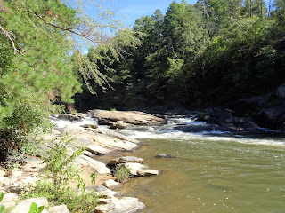
| Canopener rapid |
Located
west of Westminster on 200 acres along the Chauga River, the park is managed by
Oconee County Parks, Recreation and Tourism. It takes just over an hour to get
there from Greenville, but the drive is worth it as it’s easy to spend an
entire day on the river and trails. To extend your visit, book one of the 26
campsites with water and electricity, or reserve a picnic shelter or the recreation
building for a larger event. However, there are multiple picnic areas that are
first come, first serve, so bring a picnic and plan on staying a while!
 |
| Map of Chau Ram County Park |
Chau
Ram is named for its location at the confluence of the Chauga River and Ramsey
Creek. Park in the lower of the two parking areas adjacent to the rec building
and office, and you’re just feet away from Ramsey Creek and right at the base
of Ramsey Creek Falls. The creek cascades 30-40ft over large builders on its
way to the Chauga, a large granite outcrop serving as an ideal picnic space if
the nearby picnic shelters are occupied.
 |
| Ramsey Creek Falls, also known as Chau Ram Falls |
Crossing
a small bridge over Ramsey Creek will take you to additional picnic areas,
Upper and Lower Falls Trail, and the beach area on the Chauga. The sandy area
is shallow with easy access, allowing an alternative to playing in the deeper, faster-moving
waters up and down the river.
 |
| Looking upstream from the bridge, beach to left and pump house visible in distance |
There
are five sets of rapids on the Chauga River which are accessible by the 4-mile
network of trails and the 175 foot pedestrian suspension bridge over the river.
The bridge is the longest of its kind in the County, and is easily set in
motion while it’s being crossed – the kids definitely liked the swinging more
than the parents!
 |
| Chau Ram suspension bridge |
The
trails criss-cross the west bank of the Chauga, with the orange trail creating
a loop to the south, the blue trail creating a loop to the north, and the red
trails extending from the primitive camp site in the middle to the scout cabin
and north to the blue trail. To hike a 1.5 mile loop that passes all the
rapids, head north on the orange, then blue trail, and follow it along the
Chauga until you can see the Long Creek Highway bridge. Climb the stairs and
continue on the blue trail until you reach the primitive camp site; just past
that turn south on the orange trail to return to the Chauga River, returning to
the suspension bridge along the river.
Hiking
in this direction you’ll first come to Pump House Rapids, named for the pump
house across the river. The noise from the pumps is ever-present, although it
is interesting to see how the City of Westminster uses the river as a
water-intake area.
 |
| Pump House Rapids on the Chauga River |
The
narrow trail continues along the river, and late summer and early autumn we
paid extra attention to the poison ivy that seems ever-present in this region and in some spots reached out over the trail. Soon
we reached Lost Paddle Rapids, where summer weekends you can watch kayakers
navigating the rocky waters, and imagine how the rapids got its name.
 |
| Lost Paddle Rapid on Chauga River |
Not
too much further is Jump Off Rock (although on our recent visit there wasn’t
going to be any jumping as the water was too low), and then soon after the Double Red Trail splits
off towards the Primitive Camp Site area we began to hear the sound of traffic.
Just when Long Creek Highway comes into view, the trail takes a sharp turn,
climbs up several flights of stairs, and then heads steadily south along the
park boundary.
After
the Primitive Camp site you’ll reach a four way intersection. Going north on
the Red Trail takes you to the Scout Cabin and the Double Red Trail, continuing
east on the Blue Trail takes you back to the Suspension Bridge and Pump House
Rapids, and turning right on the Orange Trail takes you on a steep descent south
to Morgans Rock and the V Rapids. There is a short spur trial (the White Trail)
that goes a few hundred feed further to the west, but at this point the Orange
Trail turns east along the Chauga.
 |
| V Rapids on Chauga River |
My
favorite spot in the park is Canopener Rapids, about halfway from the V Rapids
back to the bridge. The large, flat rock is ideal for a picnic, or to just
spend a moment next to the water as it cascades down the boulders on its way to
the South Carolina/Georgia border. The headwaters of the Chauga are up west of
Oconee State Park; from there the river passes through the Chauga Narrows,
forms the Chauga Scenic River area that is extremely popular with anglers, and
runs over Riley Moore Falls before hitting the five sets of rapids at Chau Ram
and continuing south.
 |
| #DestinationOconee #ChauRamPark |
This
corner of South Carolina is wild & scenic, with the Sumter National Forest
to the northeast, dozens of waterfalls including Yellow Branch and Brasstown
Falls, Stumphouse Tunnel, and the (officially) Wild & Scenic Chattooga
River all within relatively short driving distance. But why hurry on, as you’ve
got everything right here in Chau Ram County Park…
Chau
Ram County Park is open from March 1 through November 11th and
admission is $2/car. Click here to book a campsite, and here for the Oconee
County Parks, Recreation & Tourism Chau Ram facebook page.


No comments:
Post a Comment