Showing posts with label geocaching. Show all posts

Monday, June 15, 2015

Dreher Island SP

There is a treasure trove of state parks in South Carolina, as many as 15 out of the 47 in the Upstate (depending on where you draw the line between the Upstate and Midland SC). We’re far from having visited them all, but slowly we’re checking them off one by one, discovering the unique features which led to them being declared state treasures. Not only does each State Park host unique topography and therefore flora and fauna, but the parks also widely differ in what they have to offer to the public. Our most recent state park visit was to Dreher Island State Park and included a two night stay in one of the lakefront villas.


Only 30 minutes from Columbia, Dreher Island SP actually covers three islands for a total of 348 acres and 12 miles of shoreline. Although there are a multitude of camping spots located along Lake Murray, we opted to rent one of the five villas facing south over the water, providing a fabulous view of the sunrise and sunset. Upon our arrival Friday we were immediately drawn to the water, where a miniature beach allowed the boys lake access. While they splashed the adults unpacked, and utilizing the grill and picnic tables prepared dinner. The ravenous kids ate and were soon back by the water, with first the sunset, then the campfire reflecting on their faces.


After a restful night’s sleep we ate breakfast and set off on our first adventure. There are over 25 geocaches within park boundaries, some of which are on smaller islands and the majority near the shoreline, perfect for canoeists and kayakers. We had already checked off one before heading further into the forest, in search of a second located on the tip of the Villa Lane peninsula. Walking through the woods is very pleasant, with little to no underbrush owing to the mature oak/hickory canopy. As we explored, we hugged the shore finding treasure after treasure: the geocache we had set off in search of, egg shells (probably turtle), a turtle shell and all sorts of footprints, seeds and insects.


With the boys perfectly content to return to their mini-beach for more splashing, I hit the Little Gap Trail, the longer of the two nature trails in the park. Although the ¼ mile Billy Dreher Nature Trail would have been more appropriate for the entire family, I chose the 2.1-mile hike leading out to “Little Gap”, named for the proximity to mainland at the tip of the peninsula. I strolled north through more beautiful hardwoods, with frequent views of the lake as well as abundant wildlife. Although there were other hikers using the trail, I saw at least a half-dozen deer in addition to multiple great blue herons, red-headed woodpeckers and an assortment of smaller mammals. In search of yet another geocache I found the remains of an old homesite, two chimneys still standing to attest to the family that once lived there.


For those looking to fish, with a SC fishing license you can fish for largemouth bass and stripers, catfish, bream, crappie and yellow perch. The island is a popular location and launching spot for national fishing tournaments, but luckily all was calm on our visit even with the “Paddle Bender” canoe, kayak and SUP race one morning. Once the speedboats and fisherman emerged to recreate, the quiet was punctuated with the sounds of motors and people having fun, but somehow it didn’t bother us. I’m sure we added our own cacophony at times, especially when we visited the kid’s playground and found the alligator gar skeleton!


On our last morning on Dreher Island we packed up, but pulled into the State Park loop for one last swim before crossing the bridge back to mainland. Two ospreys circled overhead for a while before perching on snags, their nest nearby. A family was decorating the picnic shelter to celebrate a graduation, and a pontoon boat was anchored in a little cove, the family enjoying the sun. It was a perfect summer weekend made even more enjoyable by good company, and I’m looking forward to our next SC state park adventure – hopefully in the near future!


* If you plan your visit for the late June/early August, you can use Dreher Island as home base to boat to Bomb Island to view the annual purple martin phenomenom, when hundreds of thousands of birds descend at dusk to their migratory roosts on Lake Murray! For more, read my post The purple martins of Lake Murray.

Monday, March 23, 2015

Pelham Mill ruins on the Enoree

Happenstance brought us to another historic site in Greenville, this one under the radar of the majority of locals, even those living nearby. With old mill ruins, river shoals and a few acres of bottomland forest, in my opinion Pelham Mill Park is one of the coolest parks in Greenville County.


Home to the first textile mill in Greenville County outside of city limits, there are scenic and historic elements that liken it to Falls Park downtown. The Upstate was largely shaped by the textile industry, and just as Falls Park contains the ruins of a mill, Pelham Mill Park contains the remnants of a cotton mill. The evidence of a complex series of stone and brick foundations spanning the floodplain, shoals and terrace overlooking the Enoree River are accessible to visitors; though, be warned - with steep, muddy footpaths, tall grass and an unfortunate abundance of trash, extreme caution should be exercised when exploring the site.


The Greenville County Historic Preservation Commission donated the thirteen acres to Greenville County in 1988. Seven acres have been added through a partnership with Western Carolina Regional Sewer Authority, and the master plan for the park includes eventual interpretive signage, picnic sites and a walking bridge spanning the river that would provide access to trails along the Enoree River. One aspect of the plan which has been completed is the dog park, and a second that is currently in the works is restoration of the former Pelham Mill Post Office.

In 2008 (source here) and now 

The building was built in 1870 as Pelham Mill’s office until the textile plant closed in 1930. It became a post office until it was closed in 1996, and when Highway 14 was widened in 2002 it was moved to its present location. Greenville Rec is restoring the historic structure for use as a community building with help from Western Carolina Regional Sewer Authority and Greenville County.

source: here

Other features of the park include a paved path leading to the historical 19th century stonework dam. An overlook provides a view of the dam, architectural remains of the mill and shoals on the Enoree River. Crumbling walls, foundations and depressions give evidence to what used to stand on the site: two steam smokestacks, underground pipes, drains, turbines, nine brick pilings, the mill’s main powerhouse and steam generator, and finally the large mortared stone dam with six sluice gates spanning the Enoree River. The Mill burned down in 1943 (except for the mill office), as the only fire trucks available had to come all the way from Greenville and Greer.


Pelham Mill is recognized by the Greenville County Historic Preservation Commission as one of 11 historic sites in the County.


On a related note, the Enoree river served another important purpose a few hundred years earlier. In 1766 NC/SC negotiated a boundary between ‘Indian land’ and their new settlement with the Cherokee. This line extended from Honea Path across the Reedy River all the way to Virginia, but today there is nothing to remind us of this aspect of southern history except a few historic markers. If you do stop at the marker, make sure to find the nearby geocache


Friday, November 21, 2014

We found Treasure! at the Upcountry History Museum

We finally got organized and scheduled a group program at the Upcountry History Museum that corresponds with their exhibit “Treasure!” Having opened in October we really should have visited earlier, as it was the perfect thrill for these pirate-loving, geocaching, treasure-hunting kids.

Our field trip included storytime and drawing in the classroom, with a discussion on what the children consider their treasures. A map was drawn – it turns out the treasure is buried under the x on an outer space beach island covered with shells and apple-palm trees with scary monkeys hanging from them, protected by shark infested waters. To reach the island you must take a fish rocket ship and follow the path marked…
The kids utilized treasure maps to explore the exhibit, using the clues given to find five different displays and learn about that aspect of treasure.  Subjects ranged from the history of treasures and treasure hunting, the technology employed in hunting treasure, as well as the people and personalities that hunt for treasure, ensuring the adults learned something as well. But since the program was aimed at kindergarteners, emphasis was placed on the interactive portions of the exhibit:  the gold rushes of the Old West, pirate treasure, underwater salvage and family heirlooms in the attic.

Once the official 90 minute lesson was over we were left to our own devices. Lauris settled in at his favorite part, the pirate ship. Complete with cannons for sinking enemy ships, I was informed we “need one at home.” One station on the ship provided the opportunity to smell things often associated with pirates (such as gunpowder), a tad more tame than the similar olfactory display Grossology at the neighboring Children’s Museum.

Mikus preferred the modern underwater submersible, mobile via remote control. Flexible to swim in all directions, the kids quickly found that the camera could be aimed outside the tank for a sort of reality thrill-cam.
My favorite station was panning for gold – it’s not every day that the museum encourages water play indoors!
Modern treasure hunting was represented by a geocaching station, complete with a pretend geocache; to really make the exhibit interactive they should have placed a puzzle cache at the location! (Although if you’re really in a mood to geocache for treasure, “The Hunt for Treasure” cache is very close by!)
The exhibit will be around until February 1st so you still have time to discover this treasure for yourself. Be sure to swing over to the related “Hidden History: The Upcountry’s Underwater Treasures” exhibit for tours of the colonial Fort Prince George and Attakulla Lodge, hidden beneath Lake Jocassee and Keowee. And if you would like more information on scheduling a group program for the exhibit, please visit the Upcountry History Museum’s website here

Wednesday, April 17, 2013

Little sister to the rescue!

It was my sister’s first visit to Greenville as well as her first time in South Carolina. Along with her arrival in the hallway at the GSP airport came spring – she proved to be a breath of fresh air in a tired routine of diapers and dishes, inspiration to share our favorite spots in the Upstate, motivation to get out of the house and exploring. We packed our days together completely full, and although it all wasn’t play, it was all enjoyable.

 
I took advantage of Zinta’s visit to take care of my 6 month dentist appointment, and after the morning spent saying “aaaagh” we headed downtown to say “yum.” I hadn’t had an opportunity nor an excuse to try the new lunch place on Camperdown, Rick’s Deli and Market. The same group that owns the West End Grille and Nantucket Seafood opened this deli/market putting the Michelin-starred Chef Emmanuel at the helm. With fresh food, premium wines and beers, and a great location this business is primed for success, and we had a great experience. Upon stepping in I was instantly transported back to France as we were ushered around a rather long line of people to a register, just because we had the two boys with us. In turn, they behaved themselves perfectly, eating their lunch like perfect little gentlemen. The sandwiches were fresh and packed with meat and flavor, the fries crisp, and the atmosphere suitable for families as well as businessmen. This is a restaurant I will bring future visitors to, as the only hiccup came when my sister’s Rueben arrived with sauerkraut. This put a smile on my face, because I imagined the chef asking “who orders a Rueben without sauerkraut?” before deciding his creation would not taste right sans… just like frequently happened in France.

 
We loaded the boys up and headed down the street to Falls Park, hitting all the high spots; the falls, Liberty Bridge, the giant beech with its exposed roots. The park really was dressed to impress, everywhere we looked flowers were throwing forth color and cheer, and the bright yellow and green buds on the trees were fresh, the colors untouched by the heat of summer.

 
Continuing along the Swamp Rabbit Trail we crossed under Main Street, to reach the train water park. With a waterfall backdrop and a train seemingly emerging from a tunnel off to one side, the specially designed water play area has shooting water jets for the children to play in during summer. The sun was warm enough for the boys to shed their shoes and splash around some, but soon enough the Reedy River captured their interest and necessitated that we move on.

 
A little farther along the trail is the Children’s Garden, which is a multi-sensory outdoor experience for children teaching everything from biology, ecology, geology and pathology to colors, the senses and gardening with some art and music thrown in. Before our move to France the garden was a magical place; every inch of the park was lovingly maintained, the plants flourishing under a very green thumb. Since we’ve returned I have noticed it seems a bit run down, but on our visit the musical instruments had been repaired and it appeared the garden will soon be planted, so it is my hope that Lauris and Mikus will witness the magic return. For the geocachers among you, make sure to cross off the “Greenville Rocks!” geocache while enjoying this beautiful spot.

 
Worn out from the sun we headed home to a nice dinner and relaxed evening preparing for a very big weekend. More on that later, but I’m signing off with this confession; one day with my littlest sister and I was a new woman. Free to cook dinner without a one-year old pulling on my pants leg, free to take a few photographs without worrying I’ve taken my eyes off the boys, free to laugh and smile with someone who knows me well. It takes a perfect day like this one to remember just how lucky I am to have the family I do.

Friday, January 20, 2012

Parc Montjuzet and 39 weeks

Roberts’s name day comes right on the heels of his birthday, and we celebrated with a trip to Parc Montjuzet, the 65-acre hilltop park visible from our living room windows. Our first visit was in January of last year on his birthday, and so it was only fitting to return this January (although we have been there since). Other than the occasional dog walker and jogger, we had the whole park to ourselves.

LŪK helping his dad blow out the candles on the kliņģeris

On our first visit we had approached on foot (and in stroller) from the south end, not knowing the layout or what we would find. After an exhaustive climb up a narrow passageway of stairs we found ourselves in a very under-developed section of the park with muddy paths and not much else. The view of Clermont was unbeatable however (you might recognize it from the background of the blog!), and we picnicked on the hillside before wandering around a bit more. From what I remember, we did find a section of the Mediterranean garden; although the climate is much different, the south-facing terraced slopes have a riviera feel. And then we headed back, without an inkling of what we had left unseen.


Our next visits revealed the numerous playgrounds, grassy picnic areas, hiking paths and vistas (located closer to the car park!) and in addition to exploring and playing we also did a little geocaching. A beautiful park, once the weather is nicer I hope to spend a lot more time there with the kids.

Otherwise the past weeks have been uneventful (considering how pregnant I am!). This time around is a much different wait from last time; with Lauris I was on high-alert starting with 38 weeks, evaluating every Braxton-Hicks contraction as a possible start to labor and agonizing the next four weeks. With the second I’ve mentally prepared for a 10 month pregnancy, and so having the baby still feels very far off. I’m also glad for the more laid-back approach from the doctor here, it is allowing me to enjoy the last weeks. In Greenville we were pressured to schedule a Cesarean starting with week 36 or 37 (estimates put Lauris’s birth weight at about 11.5 pounds, in reality he was under 9 when born at 42+) and I was visiting the clinic every couple of days for additional monitoring and stress.

Mom getting a break

I probably jinxed myself last week after telling the doctor and friends that this pregnancy has been a piece of cake. And it had been, compared to my first; this time the morning sickness wasn’t to be ignored, but on top of that my last pregnancy brought severe back pain, nausea almost the entire length of the pregnancy and general misery. So I’m not too surprised that some of the more typical symptoms are finally catching up to me, the acid reflux and difficulty sleeping being at the top of the list. But, at this point I’m committed, right?

Monday, August 15, 2011

Verona, Italy and Lago di Garda

Another two hours east of Torino is Verona, but west of Verona is Lago di Garda, the largest lake in Italy. Getting there in August takes patience, as the tiny roads were jammed with RVs, scooters, pedestrians, bicycles and cars. But we made it to Bardolino, on the southeast shore. The south end of the lake has beaches, while the west bank is all steep slopes, and although the east shore has interspersed beaches, the banks are mostly steep as well, due to Monte Baldo and the mountains to the east.

We ate our picnic lunch on a bench with a view over the lake, wishing for a breeze but staying sticky. I read later that the Dolomites to the north shelter the lake from any north winds, and although this provides a very mild climate, the south end of the lake was hot! After a little encounter with a restaurant owner barking at us in German (as we entered the internal portion of a restaurant that appeared to be a welcoming café but was in fact closed, a loud “wo gehen sie?” at a couple with a baby), we drove farther north to Malcesine searching for the cable car that would take us to the summit of Mount Baldo. We found it, but were warned that the view was cloudy (the sales desk selling the tickets provides a live video feed from the summit to aid your purchase decision), and opted to only go up only halfway. The view was impressive, but on our drive up the curving road that hugged the shore of the lake we had many beautiful views. We reached the town of Torbole, on the very north tip of the lake, then turned east through the mountains to reach the highway and Verona. The traffic in the opposite direction was backed-up at least two hours entering Torbole; we were glad to be heading on the outbound lane!

The view from Mount Baldi
A center of art, Verona is best known by tourists for the Shakesperean legacy of Romeo and Juliet. Based on the Verona of 1302 which was consumed by political conflict, the tragic couple belonged to rival families: Romeo to the Montechi (Montagues) and Juliet to the Capuleti (Capulets). The Verona we saw had this romantic aspect, but was also the most tourist-filled city on our trip so far, with everyone from Roman legionnaires to Zena, the Warrior Princess actively seeking to pose for pictures in return for a euro or two.

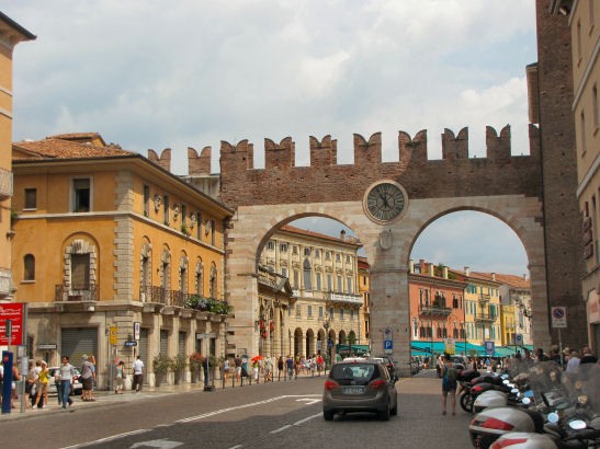
The gates leading into Piazza Bra
We started in Piazza Bra and the Arena in the city center, then wandered side streets to Casa Giulietta, where one can enter the courtyard to see the famous balcony (from which the storied Juliet spoke ‘O Romeo, Romeo…’) for free, but can ascend the stairs and stand on said balcony for a fee. It was shoulder-to-shoulder crowded, and so we headed on to Piazza Herbe, which was also crowded with its tourist market and cafes. (tip: take a right turn out of Juliet’s courtyard and enter the gelato place on the right; cones-to-go for - 1.50 euros each.) The Piazza dei Sigmori was less crowded, and we caught our breaths and admired the Venetian-Renaissance buildings surrounding the square before continuing to the river.

"O Romeo, Romeo! whereforth art thou Romeo?"
It is possible to cross the bridge on the north side of the peninsula and climb the stairs of the Teatro Romano to the terraces, which offer great views of Verona. However, although some of the stairs are stroller friendly, Roberts had quite a carry up the rest. With Lauris growing, the stroller is increasingly a better city-tour choice, even with the stroller-carrying stair-climbs that would be much easier with a baby backpack.

One tired mom and toddler after the climb to the terraces
With stops for snacks and coffee we eventually ended up at Castelvecchio and Ponte Scaligero, a castle complete with stone bridge over the Adige. The art museum is on one side, but we opted to cross the bridge and enjoy the views. Roberts was the first to notice a family furtively looking around with GPS in hand, and after watching them circle for at least twenty minutes I couldn't resist thinking of the times that I had been geocaching in similar circumstances. After they finally left, we made the find for ourselves, then backtracked to a restaurant we had seen on our walk in. After a last look at the ampitheatre in the fading daylight (which was now filling up for an opera), it was back to the hotel and a good night's sleep for this Romeo, Juliet and Lauris.

A delicious dinner
PS. Today in France is a public holiday, feast day of Assumption of Mary. Wishing everyone bon fête!

Related Posts Plugin for WordPress, Blogger...