Thursday, September 12, 2013

The Blue Ridge Parkway - this rock blows!

From Grandfather Mountain it was a very short drive back to the Blue Ridge Parkway. We still had half the day left for exploring, but wanted to make sure we were registered for a campground after the close call the previous evening. We shouldn’t have worried as the Julian Price campground at milepost 297 has close to 200 spots for RVs and tents, and we had our choice of campsites that early in the afternoon. The Julian Price Memorial Park, formerly an insurance executive’s retreat, is a 4,200 acre area on the Blue Ridge Parkway containing the campground, Price Lake and several trails. Boat rentals are available, fishing is allowed and there are several pull-offs that look perfect for a picnic. After checking out our options we chose to set up our tent in the loop closest to Price Lake, taking some additional time to organize everything for the evening as it looked like we were in for more rain. And sure enough, we had barely gotten to our next stop before the rain came.

Price Lake at dawn
 
We pulled into the Parkway Craft Center parking lot at milepost 294 in Moses H. Cone Memorial Park just as the deluge hit. Tossing on raingear we ran for Flat Top Manor, whose roof was just visible from the parking lot, hoping for some shelter until the worst of the rain passed. As we approached the mansion it became clear that we weren’t the only ones with thoughts to wait out the rain as the mansion’s veranda was full of people  - and every last one of them was staring at the scene spread out before us.
 
Perfectly situated overlooking the valley below, the covered porch was a great place to watch the storm putting on a beautiful show of lightning, fog and rain. The Victorian Neo-Colonial home was built by Moses H. Cone and his wife Bertha at the turn of the twentieth century and emulates Vanderbilt’s Biltmore Estate in nearby Asheville. While the first floor houses the Craft Center and a National Park visitors center and gift shop, the second floor can be seen during the Park Service tours. We glanced at the crafts for sale but made no purchases, stamped our National Park passports, watched the rain from the veranda just a little longer and then went to splash in the puddles. A short walk around revealed several choices of trails (which we would have considered if the lightning hadn’t been so very active) and more scenic views of the valley.

Flat Top Manor, named after Flat Top mountain nearby
 
As the rain had paused we headed to Blowing Rock, the tourist town that now provides a great jumping-off point to tour the Blue Ridge Parkway. Our destination wasn’t the crowded sidewalks of civilization, instead it was the actual Blowing Rock. Legend has it that a long time ago, when the windy cliffs of the area were home to the Cherokee and the Catawba Indian tribes (which were hostile to each other), there lived two star-crossed lovers. One day when walking near the famous Blowing Rock the reddening sky signaled to the brave that he must return to his tribal duty. The maiden urged him to stay with her, and the brave was torn between love and duty; in desperation he hurled himself off the top of the gorge. The horrified maiden beseeched the Great Spirit to bring him back to her, and the famous winds of the John’s River Gorge blew her lover back into her arms. It is said that Blowing Rock is the only place in the world where it snows upward.

 
Compared to some other destinations in the area (like Grandfather Mountain), entry was not expensive: adults $6, children 4-11 $1. Our timing was perfect as they had just reopened after lightning and thunder in the area, and we made our way out to the most fantastic views of the trip. The fog rolling up the valley after the storm made for an extraordinary scene, and each lookout brought renewed wonder at the show nature was putting on for us. The setup is nice, with a garden and pond, several short trails and an observation tower, but if you’re there, you’re there for the view.

 
A short while later we opted not to enter the traffic jam that was Blowing Rock (the town), but instead drive towards the Parkway. We saw this Mexican restaurant and made possibly the best decision of our trip – not to eat ramen for dinner, cooked huddled somewhere out of the rain, but instead take a <short> break from the camping and eat a big dinner. With full stomachs we could concentrate on the evening task at hand: building a campfire with wet firewood. And because this girl scout had her husband with, we succeeded.

Tuesday, September 10, 2013

Grandfather Mountain and the mile high swinging bridge


After spending the night in a tent at Linville Falls campground and touring the falls the following morning, we had a pretty early start on the Blue Ridge Parkway Sunday morning. The rain had temporarily let up and spirits were high as we pulled off the National Scenic Highway and joined the queue outside Grandfather Mountain. That’s right, there was a line of cars lined up outside the privately owned park. A popular tourist destination in the area, the entrance fee is rather steep – plan on spending a good bit of time here if you decide to visit. The park is open about 8-5 (this changes based on season) and adult admission is $18. Not to be confused with Grandfather Mountain State Park (to which admission is free) or the Pisgah National Forest, the private portion contains the 5,946ft Grandfather Mountain, the infamous “mile high swinging bridge,” a small zoo, a nature museum and various hiking trails and picnic areas.

Upon paying the fee we were given a brochure and an informative audio CD with information about the area that we could listen to while driving from stop to stop. We opted to drive the entire 2.5 miles to the very top and then stop at the various attractions on our way back out. The mountaintop is wheelchair accessible, although everything past the swinging bridge is rugged with large drops on all sides. The danger didn’t deter the large crowd of people intent on experiencing the spectacular views of the mountains or the exhilarating dose of adrenaline after clambering around on this peak.

Up until the 1800s it was thought that Grandfather Mountain was the highest peak east of the Mississippi, but as I mentioned in my previous post Mt. Mitchell was determined to be 738 feet taller. However, this lack of title didn’t make any difference in scenery; the 360˚ view is grand indeed. The bridge spans an 80-foot chasm at more than one mile in elevation, giving visitors access to rocky Linville Peak. The 228 foot long bridge is the second in this location; the first one was built in 1952 and was replaced in 1999 with galvanized steel. Originally made of side rails, floor boards and cables that put the “swing” in swinging bridge, there is still enough give to rock the bridge, and even though the bridge isn’t a mile above the floor of the gorge (it is a mile high in elevation, hence the name), the view down is dizzying nevertheless.

Skipping the gift shop and trails (some of which led to the State Park portion of Grandfather Mountain) we slowly made our way down the switchbacks* to the nature museum. Just beyond are the animal habitats, home to black bears, river otters, cougars, bald and golden eagles and deer. The cougars were in hiding, but we saw the rest of the animals in somewhat natural looking enclosures, even catching the otters in the water from the underwater viewing area. A stop in the museum and then we were on our way again, looking for a spot to eat lunch.

Not a dog, but a black bear
Just next to Sphinx and Split Rocks we found a secluded picnic table and settled down to lunch. We had barely finished eating when the dark rain clouds that had been threatening ever since our descent from the swinging bridge let loose a deluge, and it was a slightly wetter bunch that jumped back into the car. As the rain didn’t show signs of letting up we saw the rest of the park from the comfort of our car before turning back towards the Blue Ridge Parkway to continue our adventure.

* One of these switchbacks might be familiar looking, as it was in the 1994 movie “Forrest Gump” – it’s right before Gump realizes he’s got company on his run across the country.

Source for Forrest Gump picture: here


Saturday, September 7, 2013

Indie Craft Parade's in Greenville and a big THANKS!

A heartfelt thank you to all those that voted me and my blog to #4 on the Circle of Moms “Top 25 Southern mom blogger” list. With a very short voting period (as I only found out about the nomination with less than a week left in the contest) that included Labor Day weekend when everyone is out having adventures or busy watching football (and not stuck in front of a computer!), I was astounded at the support I received, and am immensely grateful for not only your votes but your kind comments and words of encouragement.
 
To those asking “what did you win?” – well, that new badge on the right side of the screen is about the only tangible thing…. But really, the competition once more has provided inspiration to keep blogging at a time I’m feeling confusion as to where this blog is headed, as I initially started it as an expatriate diary in France. Add to that all the new blogs to explore and local bloggers to meet, and that’s what makes the effort worth it. I hope you’ll check out not only my interview with Circle of Moms, but also the list of the South’s Top 25 Mom Bloggers!

 
More congratulations are in order… Last week I announced the first ever giveaway on Femme au Foyer, a handmade assortment of beautiful dishcloths, made by my very talented cousin Annelī. From all the entries I received Lauris pulled one name out of the hat. The lucky winner is Tim! Thank you to all those who entered, and maybe it’ll be your name pulled next time!

 
It’s a big weekend here in Greenville; not only has school restarted but it’s the 4th annual Indie Craft Parade. A festival designed especially for Greenville to showcase local artists and craftsmen, this juried crafts fair will be running today and tomorrow in the historic Huguenot Mill at the Peace Center, located at 101 W. Broad Street in downtown Greenville. It is a free festival and the hours are 9am to 6pm today, 11am to 5pm tomorrow. I attended the first ever ICP in 2010, and having missed the last two (we were living in France) I’m looking forward to stopping by, especially since I enjoyed the very similar Renegade Craft Fair in Chicago so much.

Have a wonderful weekend, and I hope to see you at the Indie Craft Parade!


Thursday, September 5, 2013

Blue Ridge Parkway - camping with small children

In my previous life (before kids) it wasn’t uncommon to grab a tent and go. While a wildland firefighter I usually slept in a tent when on a fire detail (two weeks at a time with little or no access to showers…), and as a girl scout (and now girl scout leader) annual camps would find me camping every summer and winter. My husband shares my love of the outdoors (or maybe he just shows his love for me by going along on my trips?) and we’ve hiked/camped the Pictured Rocks National Lakeshore, Isle Royale and all sorts of other places. Alone and with friends I’ve hiked and camped portions of the Appalachian trail, back country New York, crowded State campgrounds in Michigan and backyards all over. But I hadn’t spent a single night in a tent since before getting pregnant with Lauris, over 4 years ago. That is, until this Labor Day weekend.

 
Due to unexpected circumstances we found ourselves planning our cruise down the Blue Ridge Parkway very last minute. With interesting inns, bed and breakfasts and historic hotels along the entire stretch it would usually be no problem finding a place a few days in advance… unless it’s Labor Day weekend. After confirming several places were booked we switched to plan B – as in worst case scenario we will sleep in the car. But with numerous first come, first serve campgrounds managed by the Park Service (Blue Ridge Parkway) and the Forest Service (Pisgah National Forest) scattered along our route I was confident we would be able to claim a spot each of the nights we would be on the road. I packed the tent, sleeping bags and other camping gear, and started thinking about other aspects of the trip; I knew if I thought about camping with a one and three year old any further I would chicken out.

 
Our first day on the Parkway was a wet one as it rained a large portion of the day. We pulled into the Linville Falls campground at milepost 316.3 to a slight drizzle and claimed one of the last two campsites (of 69 or so) available. After popping up the tent we set off for Linville Falls, the nearby 150-foot waterfall that the campground is named for. Legend has it the falls were used by local Native Americans to execute prisoners, and my research only turned up one survivor of the final 40 foot drop - kayaker Pat Keller in 2010.

From Erwin's View overlook, taken the second day
 
The falls were donated to the National Park Service in 1952 by John D. Rockefeller, Jr. A trail departs from the Linville Falls visitor center for three overlooks. We hiked the first of the trails, to the Upper Falls overlook where the small twin upper falls are visible and visitors can see the water spiraling through a small canyon on its way to the main falls. By the time we made it the ½ mile to the overlook it was pouring rain, Mikus was getting chilled and I was having difficulty keeping both Lauris and my camera dry. We double-timed it back and jumped in the car.

The not-so-impressive Upper Linville Falls in the rain
 
This was the point I seriously doubted we would last the night in a tent. The logistics of getting everyone fed, cleaned up and into the tent (dry) seemed overwhelming, especially as both boys were starting to get antsy. Luckily my husband suggested we drive over to the picnic area and search for a shelter. We found one, just the right size to keep the two little guys dry as they were running around, keep the chef out of the rain and give us a dry spot to sit down and eat. Our “next time” list was started, and the first thing on it was a tarp to give us a dry spot in our campsite for such rainy days.

Proof that they did in fact sleep
 
Somehow we made it through the night, dry and cozy if not completely well-rested. The morning routine of getting coffee and breakfast ready before breaking down camp had a therapeutic effect on me, the tasks as familiar as the previous time I had performed them four years ago. The best part of our overnight adventure was the early start; we were only the third vehicle at the Linville Falls trailhead and had the place to ourselves until we started passing other hikers on our way out.

Erwin's View overlook
 
Choosing to bypass the Upper Falls trail this time, we took the Erwin's View trail which leads to 2 overlooks, the Chimney View overlook (0.7 miles) and the Erwin's View overlook (0.8 miles). Both provided spectacular views of the last drop of the falls, which I would not even have known was there from our experience the previous day. We were also far better prepared with the backpack carrier, rain gear, snacks and a fresh start. Linville Falls is a must-see stop on the Blue Ridge Parkway, and we were soon headed north to our next stop: Grandfather Mountain StatePark.
 

Our “next time” list:
   a tarp (for the rain)
   rope (for the tarp)
   fire starter sticks (for the rain)
   camp chairs (for dad)
 
Our “so glad we had it” list
   waterproof matches
   stovetop espresso maker
   instant oatmeal
   tin of Rīgas šprotes
   car charger
   big Maglite

** Added September 11, 2013
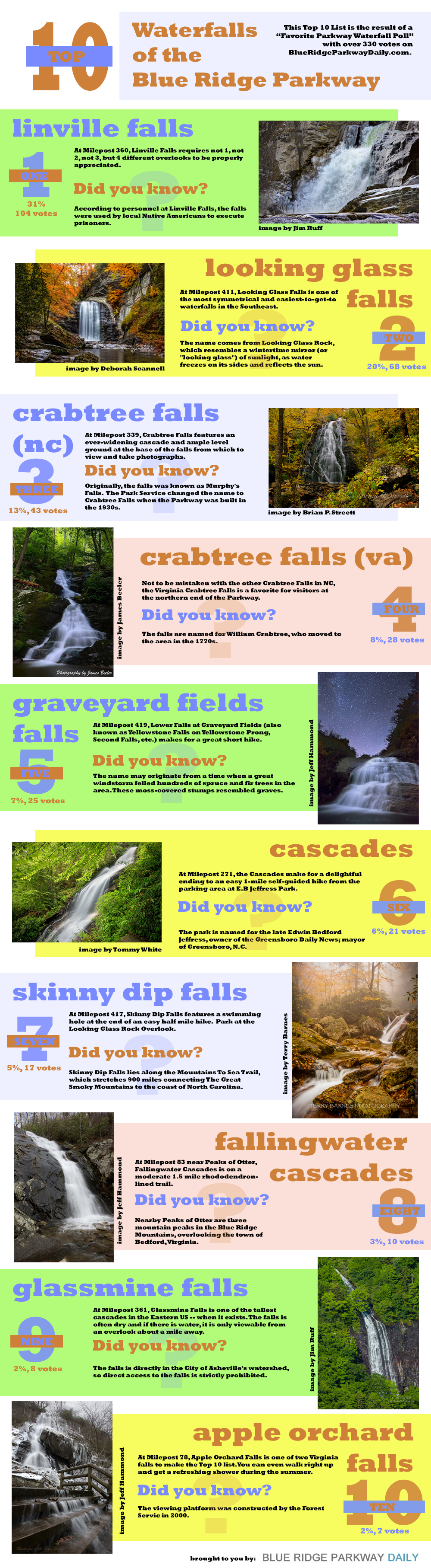
We're not the only fans of Linville Falls, they were recently voted #1 in the Blue Ridge Mountain favorite waterfall poll by BlueRidgeParkwayDaily.com!
Top 10 Blue Ridge Parkway Waterfalls

Tuesday, September 3, 2013

Labor Day on the Blue Ridge - Mount Mitchell SP

When someone says the words “National Park” usually highways don’t come to mind, but there are quite a few roadways in America managed by the National Park Service. One of them is the Blue Ridge Parkway, and we were lucky enough to spend Labor Day weekend cruising this beautiful stretch of the South. Stretching from the Great Smoky Mountains National Park on the North Carolina/Tennessee border 469 miles north to Shenandoah NP in Virginia, the Parkway follows the Appalachian mountains for endless panoramic views, historic sights, campgrounds and trails where adventures await.


We jumped on just outside of Asheville in the Black Mountains, named for the dark green spruce and fir that grow there. South of that point the Parkway follows the Craggies, the Pisgahs and the Balsams, while farther north it’s the Blue Ridge (which gives the road its name). We stopped at the Visitor Center at mile marker 384 to take our bearings, stamp our National Park passports, make a few inquiries and stretch.

The weather forecasts for the weekend all read the same: rain, chance of rain, thunderstorms likely, more rain. We passed quite a few scenic overlooks without even so much as a glance, as the views were obscured by fog and rain. In more than one spot we slowed to far less than the 35-45 mph speed limit as visibility was low, but the fog and rain lent their own beauty to the journey. The moisture clung to everything – our windshield, the trees, the road – and the fragrance of the firs hung heavy.

We opted to make the first stop we had planned, in Mount Mitchell State Park. The Black Mountains are an old range, formed more than a billion years ago. Subjected to the elements ever since they have been worn and rounded, but the igneous and metamorphic Mount Mitchell is 6,684 feet – the tallest this side of the Mississippi. Up until the 1800s Grandfather Mountain was thought to be the tallest in the area, but when Dr. Elisha Mitchell (a science professor at the University of NC) made an excursion to the area to measure the mountain elevations in 1835, he used barometric pressure readings and mathematical formulas to estimate the height at 6,672 feet: only 12 feet off. A former student and US Senator Thomas Clingman disagreed, and when Dr. Mitchell returned to gather more measurements to support his claim he fell from a 40-foot waterfall and drowned. The highest peak was eventually named in his honor – Clingman’s Dome in the Smokies (6,643 feet tall) is Thomas Clingman’s legacy.

We climbed the short distance to the viewing tower at the very peak but found visibility to be limited. I’m sure on a clear day the panorama is impressive, but we enjoyed reading up on the history of the various viewing tower and looking at pictures of Dr. Mitchell and Uncle Tom (the mountain man who found the body) far more interesting. Only minutes after departing the summit the weather temporarily cleared, and we took the opportunity to eat lunch at one of the many picnic areas, surrounded by raspberry bushes, wildflowers and the buzz of bees.

It was at this point that we took a short detour from the Blue Ridge Parkway, to Mountain Farm. I had read about this lavender, blueberry and dairy goat farm from the blog A Little Bit of All of It, and after reading on their website that species of lavender are in bloom from June to September (and still dreaming of the lavender fields in the south of France that I never got to see) thought it a detour worth taking. As we approached the rain only came down harder, not boding well for the wedding party all set up in the pasture just beyond the lavender fields, which were most definitely not in bloom. We made the best of it however, shopping at the little store and visiting with the goats that produce the aged goat cheeses and goat milk products sold on site. I was sad to hear that Mountain Farm will be closed to visitors after this year; if you haven’t had a chance to visit in person you might want to visit their Etsy store.

Despite the rain we pressed on, winding our way up the mountain roads. As we pulled back onto the Parkway and approached the Linville Falls area it was clear our Blue Ridge adventure had barely just begun.
Related Posts Plugin for WordPress, Blogger...