Monday, October 22, 2018

King Creek Falls and Burrells Ford

Despite being in a remote corner of the state, Burrells Ford remains a crossroads: historical and natural. The old wagon road (and later logging road) that forded the Chattooga was replaced with gravel Forest Service Road 708 (FS 708 or Burrels Ford Road) in 1968, allowing access to the section of the state bordering Georgia and North Carolina. Here the Foothills Trail intersects with the Chattooga Trail and East Fork Trail. Ellicott Rock Wilderness overlaps the Wild & Scenic Chattooga River corridor. Spur trails to Burrells Ford and Spoonauger Falls depart from multiple trailheads. And three National Forests - the Chattahoochee-Oconee, Nantahala, and Andrew Pickens ranger district of Sumter National Forest – converge to form one giant natural area.

Kings Creek Falls
  
But the region remains wild. Isolated, winding mountain roads require 1 ½ hours driving time to reach the campground from Greenville, including the last 3 on gravel Burrells Ford Road. At one point those wishing to camp at the Burrells Ford campground could drive right to their campsite, but all that changed when the Chattooga River received the “Wild & Scenic” designation in 1974. Now parking is in a lot just off the gravel road, and requires a ½ mile hike down the old road bed to reach the campground.


The confluence of trails can provide some confusion, and the mileages can be hard to pin down. There are two parking areas: one for the campground, and a second closer to the Chattooga on the edge of Ellicott Rock Wilderness. The Chattooga Trail (blazed green) stays along the river through the campground and emerges at this second parking area, while the Foothills Trail (blazed white) curves away from the river south of the campground and emerges adjacent to the campground parking area. There are several connector trails from the Foothills Trail to the Chattooga Trail, as well as additional spur trails to the waterfalls. Add in to that East Fork Trail leading to the only other road in this corner of the state (Fish Hatchery Road), and the horrible map posted at the trailheads, and you have an idea of why you need to come prepared with a good map if you’re planning on doing any hiking. We used National Geographic’s Sumter National Forest map on our Chattooga Trail hike, but later I utilized a Forest Service map to make a more detailed version of the campground area, as seen here.

Map of Burrells Ford campground area, as adapted from USFS map

But pack enough for a weekend, and plan to explore. Park at the first parking area (for the campground), and follow the road down to the tent sites. You’ve got bear-proof trash receptacles near the restrooms (in reality pit toilets, but luxurious compared to the alternative), and picnic tables, lantern posts, fire rings & bear poles in each campground. Some of the sites are right along the Chattooga, while others are scattered through the woods. Remember to pack appropriately, as your return trip will be all uphill. The walk in possibly deters a portion of the car campers, and the campsites cannot be reserved ahead of time; plan accordingly.


From the campground take a hike to Ellicott Rock Wilderness following the Chattooga Trail; Ellicott Rock is about 4 miles north (one way), but scenic Spoonauger Falls is less than a mile. Or, head south on the Chattooga/Foothills Trail, destination Oconee State Park (16.4 miles), Ridley Fields (11.8 miles), the Bartram Trail junction (8.1 miles) or Cherry Hill campground (about 10 miles?). Of course you could just go ahead and hike the rest of the Foothills Trail - 59.8 miles to Table Rock State Park!


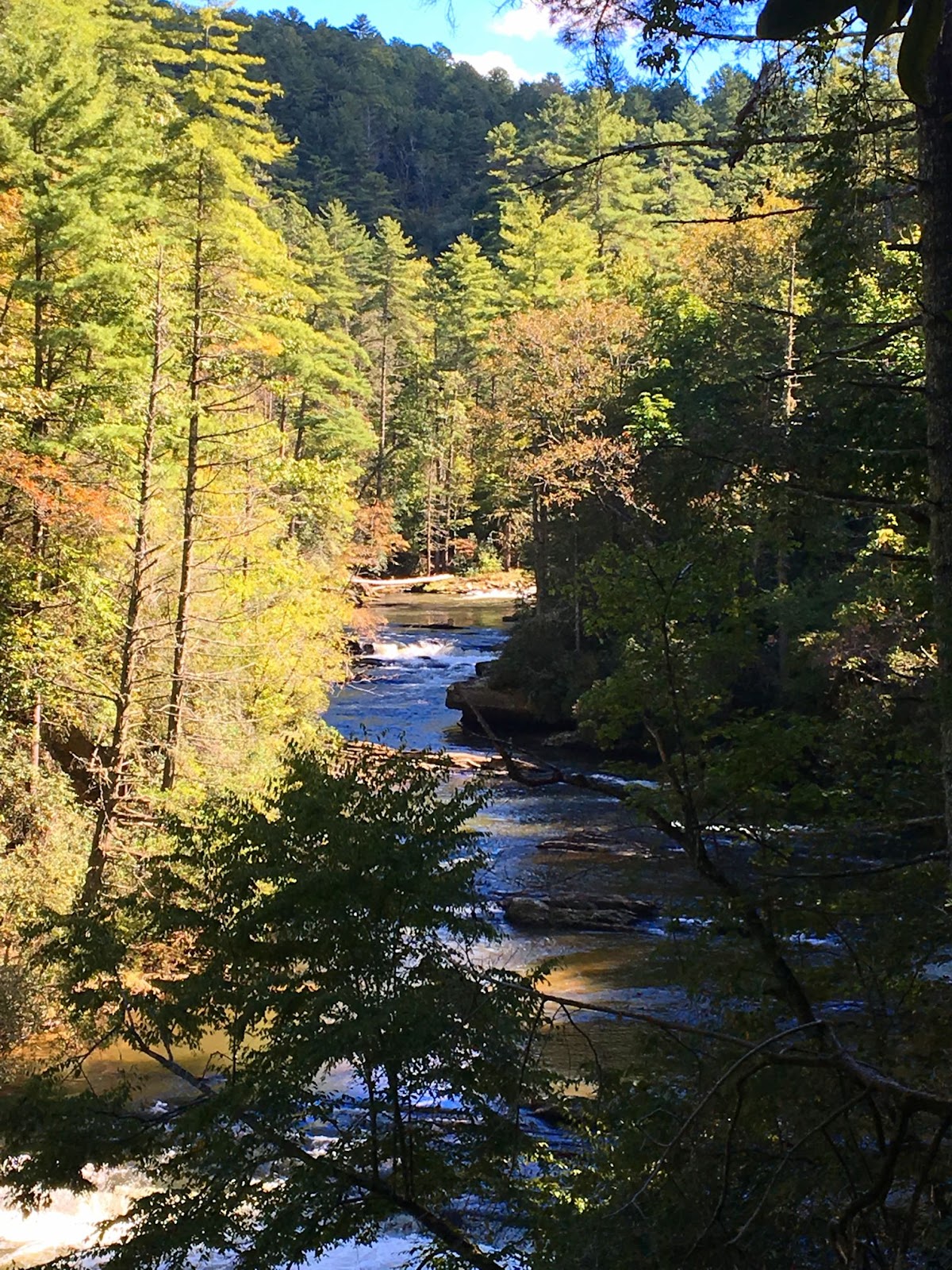
Another option is to stay in the campground; Burrells Ford is the gateway to some of the most premium trout water in the Southeast. The SC DNR stocks the river with rainbow, brown and native brook trout grown nearby at the Fish Hatchery. The river is easily accessed from Chattooga Trail and most of the campsites, and even in October the boys were happy to get their feet wet.


The high point of a stop at Burrells Ford is the proximity to two of the most picturesque waterfalls in South Carolina, King Creek Falls and Spoonauger Falls. King Creek Falls is just west of the campground, and is a 70 foot, tiered waterfall that is less than a mile, roundtrip (about 1.4 there and back if you're starting at the campground parking area).


If you are interested in reading more about the history of the area, the Rabun Chapter of Trout Unlimited posted this informative article about the Chattooga Coalition.

The US Forest Service Burrells Ford webpage is here


…and my post on the Chattooga Trail is here.


Friday, October 19, 2018

Spoonauger Falls

The Ellicott Rock Wilderness spans three states, the South Carolina portion measuring 2,859 acres in the Andrew Pickens Ranger District of the Sumter National Forest. Bordered on the west by the Chattooga River, there are three main means of access in SC: Chattooga Trail coming in from Burrells Ford, East Fork Trail from the Walhalla Fish Hatchery, and Fork Mountain Trail from Sloan Bridge Picnic Area. The three trails are strenuous treks into the backcountry, but just to the south of this remote area is a 50 foot waterfall reached by just a short trail from Burrells Ford Road – Spoonauger Falls. This hike embodies the spirit of the wilderness area, but is slightly more accessible at just 0.3 miles to reach the base of the waterfall.


We started our hike on Chattooga Trail from the trailhead on Burrells Ford Road. Hiking north in the Wild and Scenic Chattooga River corridor, we passed several nice views of the Chattooga before coming to the Spoonauger Creek crossing.


The creek and the waterfall are both named for the Spoonauger family, which lived somewhere in the area above the falls. I’ve seen the waterfall called Rock Cliff Falls, as well as Spoon Auger Falls, however the Forest Service maps indicate Spoonauger is the most commonly used name.


Immediately after crossing the creek look for the Spoonauger Falls sign, and follow the spur trail east. Just a short ascent later the waterfall is visible to your right – be cautious, as the trail can be slippery after a rain. As always, exercise caution near waterfalls, and be aware that straying off the path can cause irreparable damage to sensitive plant communities, as well as allow for erosion on the steep walls of the gorge. I have read that bats will roost in the rock crevices of the cliff, however on our visit we didn't see any bats, only salamanders in the pools below the falls. Once you've taken in the falls, head back the way you came.


The ramifications of the hemlock woolly adelgid were easily visible on this short hike, in the form of enormous dead and dying hemlocks, as well as egg sacs of the invasive insect, which resemble small tufts of cotton clinging to the underside of hemlock branches. The tiny brown-colored insect sucks nutrition from the tree’s stored reserves, and injects a toxin while feeding, causing the tree to lose needles and not produce new growth. Death of the tree typically occurs 4 to 10 years after infestation.


Having returned to Burrells Ford Road, take a short stroll down to the bridge for the view up the Chattooga. Of course, make sure to cross into Georgia so that you can make this a two-state excursion. If you were to continue on the Chattooga Trail north of the Spoonauger Falls spur trail, you would reach Ellicott’s Rock with a 4.4 mile hike from the Burrells Ford trailhead. East Fork Trail is only 2.7 miles from the trailhead, but continues another 2.4 miles to the Walhalla Fish Hatchery. For detailed hike descriptions and trail maps, I use Johnny Molloy’s “50 Hikes in South Carolina.”


Monday, October 15, 2018

The Wild and Scenic Chattooga River & trail

From its headwaters southwest of Cashiers NC, the Chattooga River runs 57 miles south, emptying into Lake Tugalo. Here, the Tallulah River emerges from the Tallulah River Gorge and is held back by the Tugalo Dam before continuing south. Water, in one form or another, forms the South Carolina/Georgia border all the way from North Carolina to where the Savannah River flows into the Atlantic. However only at the very northern section of the state is the water undammed, undeveloped, untamed – this is the “crown jewel” of the southeast, the Wild & Scenic Chattooga River.


The Chattooga was the first river east of the Mississippi to be granted the designation, allowing no roads to the river or development of any kind on 39.8 miles of the river since 1974. This is a remote corner of the state, the river bisecting the Ellicott Rock Wilderness which straddles three states (Georgia, North Carolina and South Carolina) and three National Forests (the Chattahoochee, Nantahala and Sumter National Forests). The 15,432 acre protected corridor isn’t easily reached, especially as a portion of the “wild” river is closed to boats – your transportation here will be your own two feet.


One of the best ways to experience the Wild & Scenic Chattooga is by hiking the Chattooga Trail, a 15.5 mile trail that stretches from SC Highway 28 to Ellicott’s Rock and the SC border with NC and GA. This is the section of river that is closed to boats and there is only one other road that crosses the trail – the gravel Burrells Ford Road. This isn’t to say that it’s hard to hop on the trail – there are spur trails and intersections with other trails that lead to Oconee State Park, Cherry Hill campground, the Walhalla Fish Hatchery, and to Sassafras Mountain and beyond via the Foothills Trail.


We opted to park at the Ridley Fields parking area and hike north to Burrells Ford for a total of 11.8 miles. If you add in spur trails to the many waterfalls, this total approaches something more like 14 miles. Ellicott’s Rock, while only an additional 3.3 miles north, is an in-and-out hike – the closest parking in SC is at Burrells Ford – so truly to hike the entire Chattooga would be 18.4 miles, plus any spur trails bringing the total up to around 20.


From the southern trailhead, the trail immediately turns inland, climbing in altitude away from the Chattooga and skirting the slope of Reed Mountain. There is an option to stay on an old roadbed closer to the river, but we opted to follow the Chattooga Trail, shared with the Bartram Trail. In 1765-1766, John Bartram visited the Southeast as King George III-appointed Botanist Royal in America, bringing with him his son William Bartram. William returned to explore the Southeast when he was offered financial support from a friend in England, and traversed a significant portion of North Georgia, including Ellicott Rock; the Bartram Trail continues south along the Chattooga on the Georgia side of the river from Highway 28.


Three miles in the trail descends to the river and joins the old roadbed, and not long after crosses Ira Branch. There is a spur trail here, although I’m unsure where it comes out; the indication was that it’s 3.5 miles to SC Highway something, but the number was scratched out. There were multiple campsites along this stretch, with small sandy beaches and a towering white pine canopy. Just before hitting the 4 mile mark we passed Nicholson Ford, and soon we turned into the Lick Log Creek Valley.

Bottom tier of Lick Log Falls

At 4.3 miles, a spur trail leads directly down the slope to the confluence of Lick Log Creek with the Chattooga. The unofficial trail is steep, but takes you to the base of the lower tier of the two-tiered, 80 foot Lick Log Falls. Returning to the main trail and continuing on, you can catch glimpses of the upper tier of the falls through the rhododendron before emerging to a small flat at the head of the falls.

Pigpen Falls and plunge pool

Just after crossing Lick Log Creek on a wooden bridge, Pigpen Falls is off to the right. This 25-foot waterfall marks the junction with the Foothills Trail. Taking a right and heading 0.8 miles east will take you to the Nicholson Ford parking area, and we saw several people that had taken advantage of the proximity to the Chattooga to camp for the weekend.


We followed the signs to stay on the Chattooga Trail, now hiking the Foothills Trail as well. Around 9 miles into our hike we came to Big Bend, where a steep spur trail took us down to the highest single drop on the Chattooga. The water cascades over a rocky slope before being forced between massive boulders for a 15-foot drop before widening out across the bedrock once again. Once back on the trail we soon came to the intersection with Big Bend Trail, which leads to SC 107 and Cherry Hill campground.

Big Bend Falls on the Chattooga River

The final third of our hike went quickly, with frequent stops to take in the scenery from the banks of the river. Eventually we encountered a higher frequency of visitors, signaling our approach to Burrells Ford campground. Here the Foothills Trail splits off to the east (with a spur trail to King Creek Falls), while the Chattooga Trail continues along the edge of the river. A myriad of paths crisscrosses the campground, but following the green blazes takes you through the campground alongside the river, then up through the forest to Burrells Ford Road; the trailhead has room for a dozen vehicles. Another option is to park in the campground parking lot; in this case make a right on the gravel road (which is actually the historic Burrells Ford) and follow it up to the road and parking area.


Chattooga has historically been spelled Chatooga, Chatuga, and Chautaga, and to some is known as Guinekelokee River. It gained fame as the fictional Cahulawassee River in the book and film Deliverance, but these days is much better known as a hiking, camping and fishing wonderland. A favorite of anglers due to trout released by the SC DNR, and beloved by waterfall hunters due to the number of falls on creeks that tumble down the Chattooga Ridge. In some places the river is a wide, calm river flowing over bedrock, in others it splashes noisily on down from the Blue Ridge Mountains. In the summer the green shores shade the cold mountain waters, while in autumn the colorful hardwoods are reflected in the waters around lone trout fisherman. The Chattooga is a mysterious beauty that will lure you back again and again to the most remote corner of our state. However, with each visit you’ll discover another of the many faces of this wild & scenic mountain river that defines the boundaries of SC as surely as the character of the South Carolina wilderness.

Wednesday, October 10, 2018

Artesian springs in Lee State Park

We are slowly crossing off State Parks on our Ultimate Outsider list, the ultimate goal to visit all 47 state parks in South Carolina, but with the intent to take our time and enjoy each park. Last month we spent a couple of nights camping at Huntington Beach SP, but needed a stop on the way there to help break up the drive. As it turns out, Lee State Park is located not too far past Columbia, just before Florence, SC – only 2.5 hours from Greenville.

Artisan well at Lee State Park

Lee State Park is one of several Civilian Conservation Corps parks in the state, built in 1935 to provide recreational opportunities for the residents of Lee County on the shores of the Lynches River. Named for Thomas Lynch, Jr., signer of the Declaration of Independence, the headwaters of Lynches are in North Carolina near Waxhaw. From Lee SP it flows southeast into the Pee Dee, which in turns empties into the Waccamaw River just west of Brookgreen Gardens and Huntington Beach State Park – it would have been perfect if we could have just floated from Lee the rest of the way to the Atlantic instead of having to finish the drive.


While the favorite thing to do in Lee State park may be kayaking and canoeing through the park’s hardwood forest floodplain, we were drawn to the ponds created by the artesian wells near the Visitor Center. The wells tap into confined aquifers, the pressure of the water seeping in pumping water out of the well. The CCC drilled seven wells at Lee in the 1930s of which five are still operational.


Definitely walk down the 0.2 mile boardwalk and observe the aquatic wildlife that thrives in the surrounding waters. We saw a snake, frogs, and an assortment of birds. 144 species of birds have been documented in the Park.


For a longer hike, head out on the 5 mile Loop Road. Open to all traffic, the loop takes you around to the equestrian campground, the equestrian trails on the north end, and then back along the Lynches River. There are additional artisan wells along the way. A group area that is located adjacent to the show ring and stables is available for horse clubs and other equestrian groups to rent. Lynches is designated a State Scenic River, and unique wildlife seen in the bottomland forests include the endangered wood stork, marsh rabbits, and fox squirrels.


If you bring a picnic, head to one of the two historic CCC shelters. Be sure to stop in at the Visitor Center and stamp your Park passport, but while there pick up some of the excellent brochures featuring everything from the flora and fauna of the park, a scavenger hunt (which the boys enjoyed), to a CCC history brochure. Quite a few of the State Parks we visit have the CCC in their history, but fewer and fewer have surviving structures with the classic Conservation Corps architecture.

CCC constructed bridge at Lee State Park

Lee also offers a variety of educational programs; for more on the hikes and crafts (such as pine needle basket workshops), check the Park website.

Monday, October 8, 2018

Introducing Headwaters State Forest!

East Fork Falls, Headwaters State Forest

Last month, 6,730 acres of NC mountain forests along the South Carolina border were officially opened to the public as Headwaters State Forest. A network of state parks, heritage preserves and wilderness areas protect the Greenville watershed and Blue Wall natural areas, with the French Broad River headwaters located just to the north; these are now permanently protected from development, as the new State Forest connects Watson Cooper State Heritage Preserve with the Jocassee Gorges, essentially connecting Caesars Head State Park to Table Rock State Park.


Headwaters is a decade in the making, with The Conservation Fund beginning negotiations in 2009. Public funding from the Land and Water Conservation Fund totaled $25.2 million, with funding for the acquisitions coming from the NC Clean Water Management Trust Fund, the former N.C. Natural Heritage Trust Fund and the U.S. Forest Service Forest Legacy Program. Ironically, Congress just let the Land and Water Conservation Fund expire, a shameless attack on America’s parks and public lands with Headwaters a prime example of places that could be lost forever to development if the public lands funding program isn't renewed. The conservation fund is a bipartisan, federal program that uses a percentage of proceeds from offshore oil and gas royalties to acquire critical lands to protect some of America’s most beautiful natural resources – and it expired September 30th. A troubling trend of disregard towards our last wild places has luckily so far not been felt in our region of the Carolinas, although recent recipients of the Fund such as Headwaters and the new Jones Gap addition suggest conservation efforts in the Upstate and western NC will be hindered if the Fund is not renewed in the coming months.


The previous addition to the NC Forest Service managed lands was DuPont State Recreational Forest, which is located just miles north of Headwaters, as the crow flies. DuPont is a favorite area for cyclists, hikers and horseback riders, with six main access areas to over 80 miles of trail at just over an hour from Greenville. Access to the new Headwaters State Forest is rather remote comparatively, with only a handful of roads cutting through the mountainous terrain. One of the most-easily accessible spots from South Carolina is Sassafras Mountain, the highest point in the state. Once the new viewing tower is completed, visitors will be able to look out over the new State Forest and the Pisgah Mountains from an elevation of 3,553 feet.

View from Sassafras Mountain

The Sassafras Mountain summit end is accessed by Continental Divide Road and Highway 178. Nine miles of the Caesars Head Trail, a spur of the Foothills Trail, traverse the southern border of the State Forest from Sassafras Mountain to Watson-Cooper, while the north portions of the State Forest are reached from Highway 276. Most of the road access on this side is from East Fork Road or smaller roads off of it, including the parcel that encompasses Jordan, Crawford and Pickens Mountains and is split by the East Fork of the French Broad River.

East Fork Falls, Transylvania County NC

Ranging from 2,000 to 3,600 feet in elevation, Headwaters is full of streams, creeks and waterfalls; of the at least 25 waterfalls, three are named – Gravely Mill, East Fork Falls and Reese Place Falls. One of the main Headwaters State Forest access points is the White Oak Bridge Access off Glady Fork Road, from where visitors can hike to the 40ft Gravely Mill Falls. Another pull-off (coordinates: 35.113717, -82.747781), this one off E. Fork Rd., allows for access to East Fork Falls, an 18-ft cascade. There are already 25 miles of old roads and trails open to foot traffic, including 9 miles of the Foothills Trail. Mountain bikes, horseback riders and camping are not allowed.

Foothills Trail spur to Caesars Head, Sassafras trailhead

Headwaters is home to threatened and endangered species, including Southern Appalachian bog habitat, the state-listed threatened green salamander and the federally endangered rock gnome lichen. Black bear, turkey and white-tailed deer are common, and hunting is allowed – so please remember your safety orange when hiking in the fall.


“The mission of Headwaters State Forest is to manage the lands to provide high quality water, natural resources, forest products, dispersed recreation opportunities, and education.” For more information on Headwaters State Forest, visit the North Carolina Forest Service website.

Map courtesy of the Conservation Fund


Wednesday, October 3, 2018

First Friday at GCCA // Latvian Mittens

This Friday head for the Village of West Greenville for First Friday, the monthly event at the Greenville Center of Creative Arts!


GCCA has found its home at Brandon Mill, built in 1900 and home to the baseball field that produced baseball hero "Shoeless Joe" Jackson. The beautifully restored mill houses an apartment loft community, as well as the visual arts center that boasts a variety of art classes and workshops, exhibitions of local and regional artwork, summer art camps, artist studios, and multiple special events.


First Fridays are the monthly open house event that allows the public to visit the studio artists on the 2nd floor, view the newest exhibition, create a work of art with your children, and be part of the Greenville arts community. October’s exhibition is "Textiles: A History of Expression and Last Words by Susan Lenz," and the opening reception will be Friday, October 5 from 6 - 9 pm.

Facebook event page here

Textiles: A History of Expression illuminates textiles through contemporary concepts while reflecting traditional approaches to the medium. The exhibition highlights central themes of memory, fluidity of emotion, multi-sensory experience and reverence. Using natural dyeing, meticulous handwork, embroidery, and quilting techniques, the artists invite viewers into thoughtful engagement with their experience. The artists, Alice Schlein (Greenville, SC), Sasha de Koninck (Santa Monica, CA), Beth Andrews (Greer, SC), Kristy Bishop (Charleston, SC), and Meredith Piper (Greenville, SC) re-energize the rich history of textile by continually informing their contemporary practices.”


In addition to the main exhibit, First Friday will also showcase the traveling exhibit “Latvian Mittens,” a collection of hand-knit mittens from the Latvian folk art collection in New Jersey, which is traveling the U.S. as part of the celebration of the Republic of Latvia’s 100th anniversary.


The exhibit will be available for viewing Friday at the GCCA event, and Saturday at the Spartanburg International Festival at the Latvia tent. This is a wonderful opportunity to discover the culturally resplendent tradition of Latvian knitting! Featuring the mittens as well as other authentic textiles, information on the Latvian designs and symbolism contained within, and traditional techniques, the exhibit is a celebration of the rich legacy of Latvian folk knitters.


Worldwide, Latvian mittens have become a symbol of the apex of the knitting world. Unique in their folk symbolism and technique, books about Latvian mittens have been published in many languages, and many knitters’ organizations and websites have featured original patterns, contributing to the recent Latvian mitten craze.
GCCA is open to the public and admission is free; come by and see the exhibition!

Related Posts Plugin for WordPress, Blogger...