Wednesday, November 11, 2020

Nine Times Forest, a.k.a. Big Rock Mountain

Now that autumn has descended to the Upstate, we’re revisiting our favorite local spots to watch the progression of color as we fall into winter. One of those is Nine Times, the area named for the creek named for the nine bridges that had to be built to gain access to Nine Times Preserve, beloved for the seasonal display of wildflowers.

Also see my posts:
Nine Times Preserve
Spring Comes to Nine Times Preserve

However, just across E Preston McDaniel Road from the Preserve is an area with a similar name, but with a much different claim to fame; Nine Times Forest is known for its rock climbing and spectacular views of the Upstate. 


Located near Pickens, Nine Times Forest (a.k.a. Big Rock) was protected by Naturaland Trust in 2013 and was opened to climbers in 2017. A grant from R.E.I. partially funded the construction of a parking lot off Big Rock Lake Road, allowing easier access than the Nine Times Preserve trailhead which had provided entry up until then. Then, in 2019 after the Carolina Climbers Coalition contributed another $5,000, Naturaland Trust was able to secure a 1-acre lot north of the new parking lot – creating a buffer for future expanded parking. Big Rock is the only significant cliff open year-round in SC; it faces south and can therefore be a destination during the winter months. With around 50 routes and several hundred boulder problems, there is plenty of room to spread out. And while the trails to the top of Big Rock Mountain (1,801 ft in elevation) do require scrambling up some more challenging spots, it is still accessible to non-climbers (such as my family) who do not have the safety equipment for rock climbing. 


Two main trailheads and one or two more informal trailheads provide access to the network of trails in Nine Times Forest. The main trailhead is on Nine Times Preserve, on the corner of E Preston McDaniels Rd. and Nine Times Creek Rd. From the gravel lot, cross E Preston McDaniels to enter Nine Times Forest. You’ll see the creek trail fork to the left; also called Appalachian Lumber Trail, it parallels E Preston McDaniel Road and begins and ends at connection points to the Cedar Rock Trail on the opposite side of the road. Continue up the wide gravel road instead, and when you reach the power lines you will have two options: take a left on Naturaland Way that climbs up into the Gap, or hop onto Big Rock Mountain Summit Trail and begin your ascent up (700ft of up, to be precise) to the summit. About ¼ mile before reaching the top there is an intersection with the Gap trail, and then at the top Big Rock Mountain Road provides access to the rest of the trails within Nine Times Forest – Pink Mountain is just across the gap and is 4 feet taller than the Big Rock summit. All Trails lists this route as 2.2 miles round trip, though with all the little detours we took for scenic vantage points we tracked almost 3 miles on our most recent visit. Loops that include Pink Mountain and Big Rock will be upwards of 6 miles…

An unassuming trailhead...

The second main trailhead is at the newly constructed parking lot off Big Rock Lake Road, coordinates here: 34.954252, -82.787584. Follow the trail up to the base of Big Rock and shortly thereafter hop on the Big Rock Mountain Summit Trail to finish your ascent to the summit. This option is shorter – somewhere around 1-mile round trip – but still climbs about 500ft of elevation. The last stretch of trail to the summit has the most scrambles up rocks, but this route has a few extra challenging sections. My children have been able to navigate without problems, but it helps to have an extra set of hands, especially if you have a little in a carrier. As always, exercise caution, hike within your limits, and be aware that there are inherent dangers involved in hiking in the mountains of the Upstate. Once you venture off trail all bets are off – there are no guardrails protecting you from a fall, and steep drop-offs occur in many places! 


On the summit of Big Rock Mountain you’ll find several strategically placed rocks forming a table of sorts on a level spot, perfect for a picnic. We have celebrated my birthday here with cheese and crackers, as well as taken a breather from the baby carrier; it is a safe spot for kids to run around, a gently-sloping playing field for a break from the steep sections. There are views, although the most spectacular views are from short spur trails on your climb up (though I repeat my warning about getting off-trail… some of these spur trails are used by climbers who are clipped in to safety harnesses!). 


Every time I hike this trail, I find a new view of Upstate SC to admire. While I am still on the hunt for the spur trail that will give me a view of the ‘mushroom rock’ chimney I once saw in a photo, I am grateful for these mountains that are right here in our backyard – no need to venture to North Carolina for blue ridge views! 


For more information, please see the following resources:

Tuesday, October 27, 2020

Mountain biking with kids in Upstate SC

Greenville has made headlines and received national recognition for the Swamp Rabbit Trail, but did you know the Upstate is also well-known for its mountain biking? With a dozen parks to choose from, there are options for all skill levels. We recently set out to compile a list of the best places to get some dirt under your tires! This article was originally published on the local family website, Kidding Around Greenville.

My family has recently explored a few Upstate bike parks and trails with the goal of finding some new favorites; having ridden the same local trails numerous times, the boys were getting bored. As parents, we also felt that reaching out beyond the familiar would boost their skill levels by giving them a bit of a challenge. That being said, we have one little that still needs a bit more experience before being set loose on his own, and a newborn – which means mom is hiking along more often than she’s on two wheels. With all those factors in mind I set out to put together a list of places to go mountain biking with kids in the Upstate.

A factor that comes into play when we are choosing a park is whether there is an admission fee. If we are headed out for a quick bike ride, I would rather go to a free course – and save the parks with admission for a time we can spend the whole day there. I also pay attention to the difficulty level listed; for this article difficulty ratings listed as according to MTB Project. Remember: always wear a helmet, ride within your ability, follow the local regulations, and respect trail and park closures. 


Greenville county


Sliding Rock Creek Trail: this mile of mountain bike trail is just off the Swamp Rabbit Trail, providing some urban trail that gives you the “out in the woods” feels. 
Entrance fee: none
View trail map here
Difficulty level: easy to intermediate

Riverbend Equestrian Park: 74 acres with numerous natural-surface trails are open to mountain biking, hiking and horseback riding at this county park.
Entrance fee: none
Difficulty level: easy to intermediate
Website here

Pleasant Ridge County Park: Over 6-miles of trail are located in this former state park that is located just off scenic Highway 11 in Cleveland.
Entrance fee: none
Download map here
Difficulty level: mostly intermediate, with a few sections of easy and difficult 
For more information on the park, please read my post Pleasant Ridge Falls.


Spartanburg


The brand-new Vic Bailey Subaru Bike Park is located off the Mary Black Rail Trail near South Pine Street. The park has features for bikers of all skill levels including a pump track, dirt jump area, a boulder garden and a perimeter trail.  
Entrance fee: none
View map here
Difficulty level: easy to difficult

Duncan Park Bike Trails: Six miles of trail in the woods of Duncan Park feature plenty of jumps and pump turns.
Entrance fee: none
Difficulty level: easy to intermediate
Website here

Edwin M. Griffin Nature Preserve/Cottonwood Trail: This 116-acre urban preserve and trail system is located minutes from downtown Spartanburg.
Entrance fee: none
Difficulty level: easy to intermediate
Website here

Holston Creek Bike Park: The park is located in Inman and is managed by the Spartanburg County Parks Department. In addition to the mountain bike course, the park also has a disc golf course and a playground.
Entrance fee: none
Download map here.
Difficulty level: intermediate


The South Carolina State Parks


Paris Mountain State Park
: The Paris Mountain trails were the first trails my boys went mountain biking on! With 15 miles of hiking/biking trails in the park, there are sections appropriate for all skill levels. Please note that that biking is not allowed on any of the trails on Saturdays.
Entrance fee: yes
Download a trail map here.
Difficulty level: easy to difficult
For more information on the park, please read my post Paris Mountain State Park.

Croft State Park: Bike one or all of the more than 20 miles of mountain biking trails in the park! The multi-use Croft Passage of the Palmetto Trail is also located within the park, but be advised that the bridge near the southern terminus washed out in February and has yet to be replaced.
Entrance fee: yes
Download a trail map here.
Difficulty level: mostly intermediate with a few difficult trails mixed in.
For more information on the park, please read my post Croft State Park.

Sadlers Creek State Park: The loop bike trail is 6 miles long with a trail rating of easy. Its location near I-85 makes this an appealing choice for residents of Anderson.
Admission fee: yes
Download a trail map here
Difficulty level: easy


Palmetto Trail 


Stumphouse Mountain Passage and Stumphouse Mountain Bike Park
: The 1.5-mile passage of the Palmetto Trail is a multi-use connector that serves as the gateway to the 10+ miles of mountain bike trail within Stumphouse Mountain Bike Park.
Entrance fee: yes
Download a trail map here
Difficulty level – intermediate to difficult
An article on Stumphouse Mountain Bike Park here.

Oconee Passage: From Oconee State Park to Oconee Station State Historical Site, the passage drops about 1,000 feet for a challenging, one-way descent from ridgeline to cove.
Entrance fee: Oconee SP yes, none at Oconee Station SHS
Download a trail map here
Difficulty level – intermediate/difficult

Croft Passage: The 12.6-mile Croft Passage is shared by hikers, cyclists and equestrians! Please be advised that the bridge near the southern terminus washed out in February and has yet to be replaced.
Entrance fee: yes
Download a trail map here. 
Difficulty level: difficult

Blackstock Battlefield Passage: Four miles of nature trails, camping, and first-rate mountain biking along a remote section of the Tyger River where Revolutionary War patriots defeated the British.
Entrance fee: none
Download map here.
Difficulty level: intermediate/difficult

Enoree Passage: The 36-mile Passage along with the numerous trails on the Enoree Ranger District of Sumter National Forest provide extensive opportunity to experience biking on natural surfaces.
Entrance fee: none
Download Enoree Passage maps here.
View additional Sumter National Forest maps here
Difficulty level: easy to intermediate

For the full Femme au Foyer guide to the Palmetto Trail, click here!


More trails and bike parks!


Town Creek Bike Park
: This is a local favorite! With everything from a pump track, dirt jumps, wall climbs, rollers and singletrack, the park also has a multi-use paved trail that is great for the little ones to ride while their older siblings are on the mountain bike trails. Signed waiver required.
Entrance fee: none
View map here and read more about Town Creek here
Difficulty level: from easy to difficult 


Bike Skills Flow Park at Gateway Park: Just off the Swamp Rabbit Trail, the bike park at Gateway has a pump track in addition to a technical flow track. The trail progression with the various challenges and terrains are designed to introduce riders to the sport while sharpening their skills. Bonus: littles can play on the playground while older children ride on the course.
Entrance fee: none
Difficulty level: easy to difficult

Central SWU Bike Trails: This brand-new trail system in Central has more than six miles of singletrack tucked into the forest next to Southern Wesleyan University's Central, SC campus. Open to hiking as well as biking, the park is park is open 365 days a year from sunrise to sunset.
Entrance fee: none
View map here.
Difficulty level: easy to difficult

Clemson Experimental Forest: The trail system is divided into three primary areas: Fant's Grove, Issaqueena/Keowee Heights and Todd's Creek. The trails are a component of a working forest used for teaching, research and extension education for natural resource management while also allowing for recreational use. With dozens of routes to choose from, there is something for everyone.
Entrance fee: none
View maps here
Difficulty level: from easy to difficult

Overmountain Victory Trail - Lake Whelchel: This 6.7-mile trail in Gaffney is part of the Overmountain Victory National Historic Trail which traces the route used by patriot militia during the Kings Mountain campaign of 1780.
Entrance fee: none
View map here.
Difficulty level: easy to difficult

For learning more about individual trails and parks, I have found MTB Project to be a valuable resource. In addition to descriptions and photos of many of the trails, there are also ratings and recommendations to help choose a destination. Another good resource is Bike Upcountry SC

What are your favorite places to go mountain biking in the Upstate? Let us know if we missed anything!

Tuesday, October 20, 2020

Hike with llamas at Earthshine!

I knew we were in for an adventure as soon as Mark, our llama guide and self-proclaimed “all things llama dude,” asked my husband if he would watch the llamas.... 


We had driven 1.5 hours from Greenville into the Blue Ridge Mountains to Earthshine Lodge, our basecamp for adventure for the weekend, with the express objective of participating in a llama hike. Mark met us with exciting news – one of the Earthshine llamas had given birth a few days ago!


Earthshine Lodge is home to four female llamas, who can be seen grazing in their pasture as visitors drive the winding road that leads up to the Lodge. We admired the llamas and the four-day-old cria (baby llama) with their colorful autumn backdrop, and then headed back up the hill to relieve my husband of his llama-care duties – of course all the hiking llamas were still happily grazing, and our infant son contentedly watching the show. 


After a quick orientation, my three older children had a rope in hand, and were each leading a llama off across the meadow. The 76-acre Earthshine property has multiple trails for exploration, and we had a mile-long loop planned. As we hiked across the meadow and into the autumn-cloaked forest, we learned more about the llamas; not just what they can and can’t eat and how to properly guide them, but also about their individual personalities. My 8yo led “Vision,” a gentle but very alert llama who evidently has the best eyes of the group, while the 6yo and 10yo followed with “P Diddy Peaches” and “Legend.” All the llamas were well-behaved, responded to the guidance of their novice guides, and provided the boys with an extraordinary experience that they are already asking to repeat! When not out on Earthshine hikes, the llamas are offering wilderness therapy to special needs kids through the S.O.A.R. 3-day, 2-night Llama Trek Expedition in Panthertown Wilderness area, being ringbearers at weddings, or surprising guests at birthday parties; think of an occasion that wouldn’t be livened up by a llama… these are some exceptional llamas! 


As we descended into the valley’s magical mist, I marveled at the scene before us; the wooden Earthshine Lodge rising stately on the ridge overlooking the surrounding valleys, reminiscent of the great lodges of our national parks. The views from the lodge stretch into the distance on a clear day, and on this autumn afternoon the sight of my boys traversing the meadow was storybook-perfect.


Having returned to the lodge and each hugged our llama a couple of times goodbye, we sat down for a delicious dinner prepared by Earthshine Lodge chef, Shelley. A perfect end to the day included warming up from the chill of the evening with a cup of hot chocolate – all the while soaking in the magic from the mountain view. Once darkness fell, we tucked in the boys in their loft nook and snuck away to one of the several chairs on the outdoor terrace for a minute. However, the lure of a warm bed proved to be too hard to resist, and soon we too were dreaming llama dreams… 


There is a good reason for their slogan “Your Basecamp for Adventure”; Earthshine is located right in the middle of some of the most breathtaking public lands in the Carolinas. Sandwiched by the Pisgah and Nantahala National Forests, the Lodge provides access to popular Gorges State Park, DuPont State Recreational Forest and Panthertown Valley. The proximity allowed us to reach popular trailheads before they got too crowded, although it was hard to leave the property because there was more to do on site – an example being the hammocks in the trees just calling for a daytime nap. 

Gorges State Park is only 15 minutes away!

Earthshine started thirty years ago with a mission to provide environmental education and family vacations, and then in 2018 new owners stepped forward to continue the legacy as well as add to it; all that time the natural beauty of the Lake Toxaway region has nourished and grown the experience to what is today. Earthshine Lodge is not just a place to stay – it is full immersion into a Blue Ridge adventure! Whether you choose to book a family vacation and take a wilderness skills workshop, or want to celebrate an anniversary with a romantic weekend away, the mountain oasis is a retreat from the chaos of the year. 


Speaking of the chaos of 2020… Earthshine is taking all precautions to keep visitors safe, including even small details like disinfecting the llama lead lines. For those e-learning, homeschooling and learning remotely, Earthshine Lodge has wi-fi, and offers multiple programs to incorporate into your curriculum such as Cherokee Village (pottery making), Pioneer village (where guests can try their hand at blacksmithing, wool felting and candlemaking), art-based activities (nature art and seasonal crafts), the before-mentioned wilderness skills classes (including shelter construction and fire-starting), geology and hydrology (creek hikes with gem mining), and more! During the week the Lodge caters to school groups with programs that have been updated to support state standards, while on weekends various retreats are held, with workshops on everything from mindfulness to fly-fishing. On our visit we had the option to join in outdoor yoga, archery/tomahawk throwing, and a “paint & wine” – check the calendar on their website to see what fun opportunities are available during your stay. 


The llama hikes continue through the year, occurring two or three days a week at several different times. For three weekends in December they will take a backseat as an add-on to Earthshine’s Appalachian Christmas, an all-inclusive holiday package featuring meals, caroling, pioneer village activities, crafts, a movie and the highlight – brunch with Santa! For rates and times, please visit the Earthshine website. And for the cutest baby llama pics, check out their Instagram and Facebook pages! 


We thought we had signed up for a hike with a llama. What we didn’t realize was that we would return from our weekend feeling so well-rested and healthy after a peaceful yet high-adventure weekend in the Blue Ridge Mountains. And we certainly didn’t imagine we would be among the first to greet an hours-old llama to the world! As we were leaving, we stopped by the llama barn where the tiny cria was shakily standing on four legs, marveling at the world from under the gaze of her protective mama. Unforgettable moments for the kids, thanks to the Earthshine family! 

Earthshine Lodge
1600 Golden Road Lake Toxaway, NC 28747
https://earthshinenc.com/
info@EarthshineNC.com
(828) 862-4207

This post was first published on Kidding Around Greenville

Tuesday, October 13, 2020

Town Creek Bike Park

With the advent of cooler weather, the kids have been spending more time on their bicycles, not just in our neighborhood, but in numerous local bike parks. Today I want to share one of the boys’ favorite places to hit the trail on two wheels: Town Creek Bike Park.


Located about 30 minutes from Greenville, the Town Creek Bike Park is located at 545 State Rd S-39-190, just north of Pickens, SC. You’ll see a sign for “Pickens Recreation Center,” and after making the turn, proceed to the far end of the parking lot. There you’ll see a kiosk with a map of the park, as well as a box for waivers; a second waiver station and the park rules are located just past the park entrance. The City of Pickens asks that you please fill out a waiver form before using the park, and riders under the age of 18 must have a parent’s signature. At the kiosk you can also see a map of the park, including the difficulty legend for the various trails.


The park is a large playground for kids on bikes. With single track, a pump track, half-log trails, earthen & wooden rollers, jumps and wall rides, the course is challenging yet offers plenty of choices for younger and less-experienced riders. We’ve visited with a kid who is still on training wheels, and have ridden on the 8’ wide paved trail called the “Appalachian Lumber Greenway” that follows the historic Appalachian Lumber Company railroad route from the Pickens Recreation Center around the bike park to a playground. Most of the intermediate and difficult features also have bypass trails.


A large portion of the park is forested, providing shade on hot summer days. This does affect visibility though, and the park is big enough that you can’t see from one end to the other – we utilize the buddy system for safety, keeping the younger riders paired with an adult or more experienced rider.


Just like most of the bike parks in the Upstate, the course must be dry when used in order to keep it in good shape. To prevent the dirt features from being damaged and posing a hazard to the riders, the course is closed and cannot be used when wet. As a general rule, if there is an inch of rain, the course will remain closed for one day, if there are two inches of rain, the course will remain closed for two days, etc. The course may also be closed for major holidays, extreme weather conditions, and for special events; you may want to call ahead if there has been rain.


To read a detailed list of the features available at Town Creek Bike Park, please visit the City of Pickens website. The course is only open during park hours. There is no cost to use the Bike Park, and there is no attendant on duty. Remember to ride within your abilities, respect all park rules, and have fun while staying safe.


Before you go:
  • Double check that the park is open, by checking the calendar on the City of Pickens website, or by calling the Recreation Department at (864) 898-8155 and getting an update via the recorded message.
  • Bike Park riders need to sign a waiver and wear a helmet and other recommended protective gear. You may complete a waiver at one of the kiosks at the Bike Park or you may print one from the Town Creek Bike Park website at this link and bringing it with you. Once you get to the park, place the signed waiver in the designated slot in one of the kiosks.


If you liked Town Creek Bike Park, you might also like:

Thursday, October 8, 2020

Cruise into an Upstate Autumn

Autumn is here, bringing cooler temperatures and breathtaking fall foliage in the Blue Ridge Mountains! Take a driving tour this fall up the Blue Ridge Escarpment for a showcase of what our region has to offer...

Travelers Rest SC to Brevard NC Loop 

Get an early start to beat the crowds at Tandem Creperie, a local favorite in Travelers Rest. Fortified with coffee and crêpes, head north on Highway 276 into the Foothills. Passing through Marietta it is only a short detour to the Beechwood Farms farmstand, where you can stock up on freshly-picked apples to snack or pick a pumpkin from their pumpkin patch. Continuing north, soon after Cleveland, SC is your second stop, Wildcat Wayside. The roadside destination is the perfect introduction to the mountains, as Wildcat Branch tumbles down over three waterfalls on its way to the South Saluda River. Have just 15 minutes? Take a photo at the lower falls and then buy a bag of boiled peanuts from the vendor who has usually set up in the parking lot before heading on. Have 1-2 hours? Hike the 1-mile loop path that leads up past the middle falls to the upper waterfall.


Wildcat Branch Falls

Next stop, Bald Rock Heritage Preserve. In recent years the vandalism of this beautiful natural area has been on the uptick, however the views from the enormous granite escarpment are still unbeatable. Cross the small footbridge and walk a short distance to find a stunning vista of the Upstate; on a clear day Greenville can be seen to the SE, and Table Rock to the SW. In the parking area peruse the back of a local vendor’s pickup for an assortment of jams and jellies before continuing up 276 into the Mountain Bridge Wilderness.


View from Bald Rock

As you climb the Blue Ridge Escarpment through endless switchbacks, you’ll find plenty of fall color; from the red maples and sourwoods at the very beginning of the season, to the deep reds and purples of the oaks into November. Take a break from the winding road at Caesars Head State Park, walking a few hundred feet to the overlook for more breathtaking views, and keep an eye out for migrating hawks; although the numbers are at their highest in mid-September, you’ll find members of Hawkwatch on duty through November to count the migrating raptors soaring the thermals en route south.


View from Caesars Head State Park overlook

Making your way north into Brevard you’ll pass through the community of Cedar Mountain, with an eclectic collection of shops, galleries and other curiosities. The descent into Brevard gives you time to discuss your options of where to stop for lunch!


Headed north on US-276

Once back on the road, take US-64 W to US-178 and head south from Rosman. You’ll soon cross back over the Eastern Continental Divide (the first time was on 276 crossing into NC) into South Carolina, and start your descent from the Escarpment. There’s still a 'high' point to come, however; from Rocky Bottom head east up to Sassafras Mountain, the highest point in South Carolina. From the brand new observation deck you can take in views of the entire region, with views extending to Georgia on a clear day.


End of summer goldenrod on Sassafras Mountain

Once you’ve descended from the escarpment, take the Cherokee Foothills Scenic Highway east to Table Rock State Park. Stop at the Visitor Center, walk out on the pier on Lake Oolenoy, and soak in the view from the rocking chairs overlooking a meadow, the lake and Table Rock in the distance. Have more time? Drive over to the other side of the highway and drive Table Rock State Park Road all the way around, with stops at the Lodge, Pinnacle Lake and a scenic overlook as inspired. Note: the north portion of the Park has an entry fee.


View of Table Rock from the Table Rock State Park Visitor Center

Continuing west on Scenic Highway 11 you’ll pass Table Rock Tea Company, and then a little further Aunt Sue’s Country Corner (Victoria Valley Vineyards just to the north) & Pumpkintown Mountain. If you’re planning a stop here, make sure to check websites for operating hours. Finally, enjoy the last light of the day reflecting the gold and orange hues of the forests blanketing the Blue Ridge Escarpment as you make your way back east on the Cherokee Foothills Parkway!

While the entire driving tour takes a good 2.5 hours, plan to make several stops along the way to enjoy the sights; I would plan 5-8 hours to allow for time at the scenic overlooks. Remember to bring a camera, a coat for once you’re up on the Escarpment, and a map if you’re not familiar with the area – you won’t have cell service for a portion of the drive. Enjoy your Blue Ridge autumn, and let me know in the comments if you have any favorite stops along this route!


For more options on seeing the best of autumn in the Upstate, see the following posts:


Tuesday, October 6, 2020

Stumphouse Mountain Bike Park

Stumphouse Park gets busy on weekends! It is home to the unfinished Stumphouse Tunnel that was dug using hand tools prior to the Civil War, as well as the well-known Issaqueena Falls, both of which I've previously written about here on the blog. There is also the Blue Ridge Railroad hiking trail, a moderate hike to two more abandoned rail tunnels. However, the highlight of the 440-acre park is the least-crowded – Stumphouse Mountain Bike Park.


The main entrance for the Mountain Bike Park is also the trailhead for the Stumphouse Mountain Passage of the Palmetto Trail. The nearly-continuous network of trails stretches from Oconee State Park in the Upstate Foothills, to its low-country terminus at Awendaw and Buck Hall on the Intracoastal Waterway. Established in 1994, it is South Carolina’s longest pedestrian & bicycle trail. Today 350 of the proposed 500 miles of trail have been completed, and the Stumphouse Passage is one of the newest!


From the trailhead, the Stumphouse Passage follows Cane Creek past the Walhalla Reservoir for 1.5 miles. In the future, the Ross Mountain Passage will connect it with Oconee State Park, but for now it provides access to an additional 10 miles of bike trails within the park. A few more trails are in the works, including a short spur trail (hikers only) that leads to a small waterfall on a tributary of Cane Creek.


The Passage/Mountain Bike Park was a collaboration between many parties: the City of Walhalla, Oconee County, Upstate Forever, Oconee Forever, Palmetto Conservation Foundation, Walhalla Partners for Progress, Oconee County Chamber of Commerce, Visit Oconee SC, the SC Dept. of Parks, Recreation & Tourism, the SC DNR, the U.S. Forest Service, REI, Upstate SORBA, Benchmark Trails, and the South Carolina National Heritage Corridor - WOW. While the city of Walhalla owns the 440-acre Heritage Preserve, Upstate Forever holds a permanent conservation easement on the property, allowing visitors to enjoy the trails for generations to come.

Clockwise: Yellow-tipped Coral Fungus, Cardinal Flower, Imperial Moth, snail

There is an entry fee of $5 per vehicle (but free for City of Walhalla Residents, and annual passes are available). For parking, follow signs for the Palmetto Trail trailhead, where you will also find picnic tables and restroom facilities. There is no water available once you’re on the trails, so pack in/pack out.

This mushroom had been knocked over, catching our eye because of its size!

On our most recent visit I hiked the Palmetto Trail with my youngest in a carrier, while the six year old rode his bike; there were some sections that he had to dismount and push his bike up, but not many. Meanwhile, the two older boys set off with their dad to explore the rest of the mountain bike trails. They gave rave reviews, and in terms of technical difficulty only the 0.68 mile one-way, black diamond trail was close to being too challenging - but as always, know your capabilities. 

Palmetto Conservation Project Manager Jim Majors made sure the trail route passed by this giant
when he was mapping out the trail

Things to do before hiking/biking Stumphouse Park:
  • Call (864) 638-4343 option 4 to find out if the park is open or closed. The park is closed after significant rainfall in order to protect the trails.
  • Review your bike etiquette. Mountain bikers must yield to hikers, and on descent yield to uphill traffic.
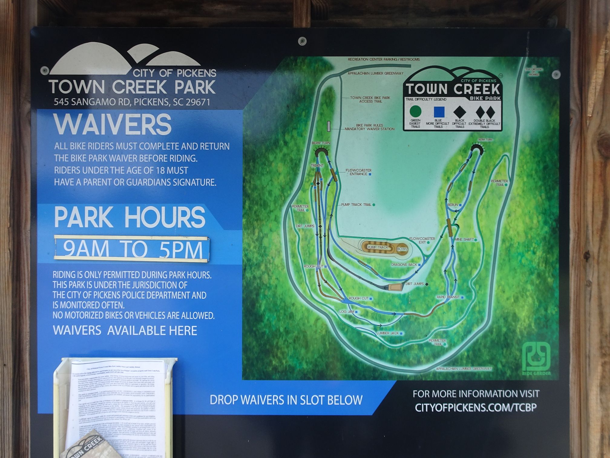
  • Download a map (or print out a paper copy), available here.
  • For additional information, email info@stumphousepark.com.


If you still haven’t gotten your fill after the three mile roundtrip hike, drive to nearby Yellow Branch Falls on the other side of Highway 28; Stumphouse Park is bordered by the Andrew Pickens Ranger District of Sumter National Forest. The moderate 3-mile hike leads to a beautiful 50-ft cascade. You can also head to Oconee State Park and Oconee Station, or just cruise Scenic Highway 11. One of our favorite areas in the state, whatever mode of transportation you might choose – bicycle or foot – you’ll find adventure at Stumphouse Park!

Tuesday, September 29, 2020

The Saluda River at Dolly Cooper Park

There are those days when I just have to get outside, but the state parks are at capacity and the mountains are too far. Nearby Lake Conestee Nature Preserve is a fantastic urban green space, but sometimes I just need something a little different. Thanks to AllTrails, I’ve found some hikes in unexpected places – most recently, Dolly Cooper Park.


Although technically in Anderson County, the park is just across the Saluda River from Greenville County in Powdersville, about a 15-minute drive southwest. After cutting over to River Rd. From Anderson Road, visitors pass by the Recycling Center before entering the park. A paved parking area near the front accommodates visitors to the front ball field, and then an enormous three-level gravel lot handles additional parking for the disc golf fields and the baseball field. There is a paved, third lot near the river and canoe launch which should re-open with the conclusion of the construction.


Currently home to a full 18-hole disc golf course and a couple of ball fields, the park has enormous potential in its 40-acres. This year Anderson County Parks launched a $350,000 construction project, putting boulders up to prevent instances of vandalism, as well as constructing a new kayak launch to replace the old plastic one that kept being damaged in floods.


The shore line access trail project has yet to be completed, but a new trail has been paved that curves east along the Saluda from the pier. The trailhead to the River Walk is by the kayak launch parking lot. It meanders between the open fields of the park and the strip of forest that lines the Saluda. The ¼ mile-long trail offers access to multiple spur trails that provide views of the river, and ends near an old bridge foundation.


Dolly Cooper Park was named for M.J. ‘Dolly’ Cooper, who was elected to the S.C. House of Representatives in 1974 on a platform of bringing more health care services to Pelzer, Piedmont and Williamston, and served in House District 10 for 16 years. Cooper was known for his World War II military service, where he served as a combat infantryman with the 30th Infantry Division. He saw 11 months of combat in Europe including action at Normandy & the Battle of the Bulge, and he was awarded the Purple Heart, Bronze Star, American Defense Silver Medal and the Combat Infantry Badge.


The park was briefly closed in 2016 due to lack of funding. A proposed tax hike was not passed by the County Council, and it was mentioned that without additional funds it was too hard to keep the park maintained and safe. However the canoe/kayak launch is one of the only public launches on the Saluda, and after public outcry the park was soon reopened. While vandalism has been a problem over the years, it seems as though recently there has been a push to upgrade the park as Anderson County moves forward with a park and recreation master plan. In my opinion the park could benefit from a few work days to get the litter picked up and the kudzu under control – as could most large parks in the Upstate. There is plenty of room for a playground, and this might be a great spot for a Kids in Parks TRACK Trail. A lot of potential, but from the sound of it, only a little funding...


So as to not to end this post on a negative note, here are the things that will bring me back to Dolly Cooper:

  • The hardwoods lining the Saluda put on a pretty show in autumn
  • Public river access to the Saluda is rare on this section, with the boat ramp on the Saluda River in Pelzer one of the only other spots that comes to mind
  • We had the place to ourselves
  • With 40 acres of park it’s easy to put together a few mile walk
  • It’s only a 15 minute drive
  • The Saluda is a beautiful river, with little development visible on its shores
  • You can always find beauty in nature, no matter how urban the park!


Good luck to the folks over in Anderson County with the park upgrade, and hopefully the boat dock is finished soon. Is there anything you would like to see happen in Dolly Cooper? Let me know in the comments!


Related Posts Plugin for WordPress, Blogger...