Showing posts with label lighthouse. Show all posts

Friday, July 13, 2018

Gulf Islands - Pensacola Lighthouse

Although it’s the Forgotten Coast that is known for its lighthouses on this stretch of the Gulf, the Emerald Coast holds its own; the Pensacola Lighthouse is a striking addition to the region that allows for a different perspective of Florida’s scenic coastline.


If you plan on visiting the Pensacola Lighthouse, be aware that it is located within the Naval Air Station Pensacola, an active military base. All civilian visitors must enter through the West Gate (beware your GPS directions!) and must show proper identification; please see the lighthouse website for more details. On our recent visit we were more prepared than the time we tried to visit the Cape Henry Lighthouse (as in, we knew we would be visiting a military installation!), and made it through the security checkpoint with little delay.


The lighthouse is open to visitors daily (except for certain holidays) from 9am to 5pm, however the last climber is admitted to the tower at 4:45pm so make sure to give yourself plenty of time to get through the security checkpoint. Admission is $7/adult, $4/children under 12, $4/seniors and $4/military. Please note that on days that the Blue Angels are practicing there is an increased admission of $20 and reservations are required as space is limited (see my post on the National Naval Aviation Museum for more on the Blue Angels).


Construction of the first lighthouse in the area was begun in 1824, resulting in a 40ft white brick tower equipped with 10 whale oil lamps. Over the next thirty years Fort Pickens was constructed at the western tip of Santa Rosa Island, Fort McRee was built at the eastern tip of Perdido Key, and Fort Barrancas was built on the bluffs a half a mile east, the three forts tasked with defending the mouth of Pensacola Bay. Florida was admitted to the Union, and then in 1854 funds were appropriated to replace the Pensacola Lighthouse. Construction began a half mile west of the original in 1856, and on New Year’s Day, 1859, the new lighthouse was lit for the first time. 151ft tall, it boasted a first-order Fresnel lens.


In 1861, Florida seceded from the Union; Confederate troops took Forts Barrancas & McRee and along with them the lighthouse, and in December the base of the tower was struck by shot from Fort Pickens and damaged in at least three places. When Union forces took possession in 1862, a captured fourth-order lens was installed, the first-order lens not being restored until 1869. Over the years the lighthouse was damaged by elements ranging from lightning to ducks, but the structure survived earthquakes and hurricanes as well as full automation to be listed on the National Register of Historic Places in 1974.


Named one of the most haunted lighthouses in the US, the Travel Channel and Syfy’s Ghost Hunters have investigated the site (See season 5 episode 22 of Ghost Hunters). Today visitors can take a ghost tour in the historic 1869 Keeper's Quarters, or purchase a copy of Ghostly Beacons: Haunted Lighthouses of North America in the gift shop to learn more about the various grisly happenings that have happened over the years, and the paranormal activity that supposedly goes on in this 160 year old structure.


We crossed to the lighthouse in the dappled shade of enormous live oaks, and then it was 177 steps to reach one of the most beautiful views on the Gulf Coast. We could see Fort Pickens and the white sands of the Gulf Islands National Seashore, the dark green treetops of pines and oaks scattered through the military base, and in the distance the skyline of Pensacola. Just to the east was Fort Barrancas, on our itinerary for later on in the morning, and beyond it all stretched the blue waters of the Gulf.


Only two of the boys elected to climb with me, and so Roberts stayed grounded with Vilis while we went on our lighthouse adventure. The 1890s Carriage House was renovated in the 1990s to serve as the Visitor’s Center and museum shop, and when they were done exploring that they headed out to blue waters on the short Nature Trail. Although no swimming is allowed, the crystalline waters of the Bay and Gulf washing up on the white sand beach are always a treat for bare feet.


We timed our visit to coincide with cooler morning temperatures, heading to the adjacent National Naval Aviation Museum (and air conditioning) once the heat settled in. The boys agree that the climb to the top was worth it, and we suggest a stop at the Pensacola Lighthouse for anyone visiting the area.


Tuesday, May 1, 2018

Lighthouses of the Forgotten Coast

My middle son is the lighthouse aficionado, the one who always says yes to climb to the top of the many lighthouses we’ve encountered in our travels. Our recent trip to Florida’s panhandle was no different, and although Lauris joined us on one of our climbs, it was mostly up to Mikus and me to scale these historic beacons and report back to the rest of the crew.

View over St. Joseph Bay including smoke from prescribed burn on T.H. Stone Memorial St. Joseph Peninsula State Park

Our trip started on the east end of the panhandle, and on a day trip to Wakulla Springs State Park we were delighted to find a brochure detailing the “Lighthouse Driving Tour of Florida’s Forgotten Coast.” First on the tour is St. Mark’s Lighthouse, the second oldest in Florida. Built in 1842, the tower stands on the shores of Apalachee Bay at the mouth of the St. Marks River. My first visit to the lighthouse was in 2005 during a visit to St. Marks National Wildlife Refuge, and everything looks much the same as it did then. 85 steps to the lantern room, 4 foot thick tower walls, a whitewashed exterior. The tower is not currently open to climbing, although the Keeper’s House is open the first Saturday of most months from 1-4pm.

St. Mark's Lighthouse

Continuing west on the tour route we drove through Carrabelle to the Crooked River Lighthouse. Open to visitors Saturdays and Sundays 1-4pm, we missed our chance to climb. However the 103ft iron and steel construction is not your typical lighthouse, and we were glad we didn’t skip turning into the public park. For 120 years the lighthouse was a guiding light over the pass between Dog and St. George Islands, decommissioned only in 1995 and listed on the National Register of Historic Places. A bicycle path and picnic area are also located in the park, along with a replica Keeper’s House which serves as a museum and gift shop on the weekends.

Crooked River Lighthouse

Three beacons on Dog Island were destroyed over the years, as well as three on St.George Island. The Cape St. George Light is the fourth reconstruction, located at the very center of the Island just as visitors arrive over the Bryant Patton Bridge. The first lighthouse was built near West Pass but was dismantled after being damaged by storms, and reconstructed a year later in 1848. That one fell during a hurricane in 1851, and was replaced by a third lighthouse a year later and further inland. This lighthouse served for 153 years, but ultimately succumbed to erosion, collapsing in October of 2005. Volunteers salvaged over 22,000 original bricks, and in 2008 the Cape St. George Light was successfully rebuilt and opened to the public. A replica of the Keeper’s House functions as a museum and gift shop; the lighthouse is open daily except Thursdays, hours vary by season.

Cape St. George Light

The final lighthouse on the Forgotten Coast tour is the Cape San Blas Lighthouse. I vacationed on Cape San Blas over 13 years ago and had visited the lighthouse then; I warned Mikus that we would not be able to visit this one, as the drive out to Cape San Blas involves a trip all the way out on St. Joseph’s peninsula. Wasn’t I surprised to see the lighthouse just a block off of our route while passing through Port St. Joe on the mainland! It turns out that the 130 year old structure was originally built at the tip of the cape to replace multiple destroyed brick lighthouses, and was only moved to Port St. Joe in 2014. I urge you to visit this website for the full history of Lights on Cape San Blas; it seems that the Cape is cursed when it comes to lighthouses, as even the ship that was carrying the new lighthouse sank on its way to the Cape and the material had to be salvaged from the water (not to mention the Civil War attack the Light suffered in 1862!). Mikus and I happily paid a small fee in the historic Maddox House Welcome Center before climbing the 138 steps for a grandiose view of St. Joseph Bay. In the meantime the rest of the boys paid a visit to the small beach, and before long we joined them for a final hurrah on the sands of the Forgotten Coast before heading on to Panama City.

Cape San Blas Lighthouse

This wasn’t the end of our panhandle lighthouse experience, as we would continue our adventures on the Emerald Coast, including a climb up the Pensacola Lighthouse. However it was a fitting end to our time on the Forgotten Coast and as we continued west we took one last look at the Cape San Blas Light, now just a tiny mark on the horizon.

A few points on logistics when visiting the lighthouses:
The tour brochure estimates that if combining a visit to all four the trip would take 6 hours, allowing 1 hour at each lighthouse.
Remember there are height requirements to climb the lighthouses, please check the individual websites for regulations, hours and fee information.
St. Marks Lighthouse: www.stmarkslighthouse.net
Crooked River Lighthouse: www.crookedriverlighthouse.org
Cape St. George Light: www.stgeorgelight.org
Cape San Blas Lighthouse: www.capesanblaslight.org

Monday, April 23, 2018

Cape Hatteras National Seashore on the Outer Banks


A persnickety spring has us in shorts one day, then back to bundling up the next. It’s a cold, rainy day such as today that has me dreaming of summer beach weather, which I have no doubt will arrive and have me begging for the cooler temperatures we’re presently shuffling through. Whether it is the thought of warm sunshine and ocean surf, or because this week is National Park Week, it is Cape Hatteras National Seashore that is calling to me today; this is one of a couple more posts to wrap up the North Carolina series after which I’ll turn my attention back to the Upstate & a few more Florida adventures.


Cape Hatteras National Seashore preserves 70 miles of shoreline on the Outer Banks, from Bodie Island to Ocracoke Island. Easily accessible thanks to the Virginia Dare Memorial Bridge, the north end of the National Seashore is just across Roanoke Sound from Roanoke Island (home of Fort Raleigh) and south of the Wright Brothers National Memorial and Jockey Ridge. The Bodie Island section is home to the Whalebone Junction information station, Coquina Beach, the Oregon Inlet camping area, a marina, and the Bodie Island Lighthouse and Visitor Center.


The black and white striped lighthouse that stands on Bodie Island is familiar to many, and photographs of the photogenic icon are often found in coffee table books about lighthouses and the outer banks. Construction on a first lighthouse in this location began in 1847, but the structure was shortly abandoned after major structural issues resulted in a leaning lighthouse. A second lighthouse was destroyed two years after its construction by Confederate soldiers during the Civil War, but the third lighthouse had what it takes to survive the elements on the Outer Banks, and still shines out on the Atlantic today.


The third incarnation of the Bodie Island Light was located further inland and to the north from its predecessors, and was almost twice as tall as the previous two at 156 feet; this translates to 214 steps to the top. With a First Order Fresnel Lens the lighthouse can shine its beam 19 miles offshore. A lighthouse keepers' structure was also constructed (which today houses the ranger station and Visitor Center), and the lighthouse was operational by 1872, fully automated in 1932, and came under the care of the National Park Service in 1953. Today the lighthouse and grounds are open to visitors; for more information and hours, please visit the National Park Service website.


The Bodie Island Lighthouse is surrounded by marshes, maritime forests and small saltwater ponds, making it a popular destination for bird watching. Hundreds of migratory bird species pass through annually, due in part to the location of Pea Island Wildlife Refuge south of Bodie Island. Be sure to stop in the Fish & Wildlife Service Visitor Center on your way south.


South of the Refuge are the towns of Rodanthe, Waves and Salvo. The enormous house that was featured in the movie Nights in Rodanthe was formerly located just south of Pea Island NWR, but multiple storms and a shifting coastline resulted in the structure being condemned. Two superfans of the Richard Gere-Diane Lane tear-jerker purchased it and moved it to a safer spot in 2010, and today the Inn at Rodanthe is a vacation rental.

Inn at Rodanthe: source here

Further south is Little Kinnakeet, the Historic US Life Saving Service Station. The original station building was among the first seven constructed on the Outer Banks, and the site remained active under the U.S. Coast Guard until 1954. Continuing south you’ll reach the Hatteras Island Visitor Center and the Cape Hatteras Lighthouse; the nearby town of Buxton features numerous vacation rentals as well as campgrounds, bathhouse facilities and even an airstrip in the town of Frisco.


The last island in the series is Ocracoke. With its own Visitor Center, the Ocracoke Lighthouse and additional campgrounds, the island is a popular destination despite being only accessible by ferry. A free shuttle runs daily between Hatteras and Ocracoke; visit NC Dept. of Transportation website for more info. Southwest of Ocracoke is another National Seashore, Cape Lookout. However, travel to the mainland or Cedar Island involves a 2.5 hour toll ferry.


Portions of Cape Hatteras National Seashore are open to off-road vehicles, with ramps providing access to the beach. In other places boardwalks take visitors to the water, but regardless how you access the shore, there are 70 miles of sandy beaches to explore. Go for a hike or shelling, or just choose a spot to relax, picnic and build sand castles. The constant winds coming off the ocean provide ideal kite-flying weather, and beach fires are allowed with a free beach fire permit, allowing visitors to stay late and enjoy the starry night sky. Whether you are enjoying the beach, kayaking the sound, or climbing the Bodie Island Lighthouse, Cape Hatteras National Seashore is a highlight of an Outer Banks visit that will be sure to provide memories plenty for beach daydreams until the next visit. Happy Earth Day, and happy National Park Week!

Wednesday, February 7, 2018

Currituck Beach Lighthouse

After spending the afternoon on a Corolla wild horse tour in the very northernmost reaches of the North Carolina Outer Banks, we set out to explore as much of Corolla as the remaining daylight would allow. First stop was the Currituck Beach Lighthouse.


The 162-foot lighthouse was completed in 1875, standing guard over Currituck Sound, the Currituck Outer Banks and the Atlantic. Unlike many of its Carolina counterparts, the brick lighthouse has never been painted; it was the last major brick lighthouse to be built on the Outer Banks.


It is possible to climb the 220 steps to the top for beautiful panoramic views of the Sound and ocean, although there is no access to the lens room; the first order Fresnel lens is the original lens and still operational, its light visible over 18 nautical miles away.


Entry is $10/person, and once inside the lighthouse you’ll find exhibits the history of coastal lighthouses, the Fresnel lens, shipwrecks and the lighthouse keepers. The lighthouse and museum shop are generally open 9am to 5pm – see website for details.


In the shadow of the lighthouse is the Historic Corolla Park. The parks most prominent attraction is Whalehead, a 1920s Art Nouveau-style mansion listed on the National Register of Historic Places. Tours are available, and offer architectural information as well as insight into the history of Corolla. The footbridge that connects the Whalehead island with the mainland on the north side is extremely popular for sunset-viewing over Currituck Sound, and reminds me of Venice's Ponte di Realto.


Opposite the bridge is the Outer Banks Center for Wildlife Education, which offers exhibits and outdoor programs designed to help explore the region’s coastal wildlife, natural history and cultural heritage. We did not have the opportunity to tour the Center on this visit – we were too busy flying kites and touring the lighthouse – and when the sun started sinking lower in the sky we headed north.


There are many businesses that offer tours of the area. Corolla Wild Horse Fund is the official non-profit that protects and preserves the Corolla Wild Horses, and their headquarters and museum is located on the corner of Corolla Village Road and Schoolhouse Lane.* Just across the street is Coastal Explorations, a company that offers horse and boat tours as well as rentals: kayak, SUP and bike. The Coastal Explorations pier is a well-kept secret, stretching almost ½ mile out over the marsh and sound. From picturesque views of the lighthouse rising up over the barrier island to sightings of shorebirds in the wetlands, experiencing an Outer Banks sunset over the Currituck Sound is a definite must-see on any trip to the region.


For more on Historic Corolla Park, Whalehead, the lighthouse and the Center for Wildlife Education, please visit the Outer Banks visitor guide website.


* It is my understanding that the Corolla Wild Horses Fund is relocating to 520 Old Stoney Road, south of Corolla and closer to the Audubon Pine Island Sanctuary and Center as of February 1st.


Friday, February 10, 2017

Site of the first landing and Cape Henry Lighthouse


“You haven’t been here before.” It was a statement more than a question, the park ranger at First Landing State Park responding to our inquiry of where in the park the landing actually occurred. “You want to go back out to Shore Drive, hang a left, go about 4 miles to Atlantic Ave, then make another left. Good luck!”


We pulled back onto US 60 and headed east, and as I looked at a map I commented that from this end we would also be able to see the Cape Henry lighthouse – bonus! But immediately after making the turn onto Atlantic we got our first inkling that this wouldn’t be just a casual tourist experience; a uniformed officer stepped out of his guard booth, leaned down to see the boys in the backseat, and then asked us for license and registration.


Turns out the actual site of the “first landing” (and the Cape Henry lighthouse) is within the Little Creek/Fort Story Joint Expeditionary Base, a military installation. We were asked if we had any weapons/alcohol/other stuff we thankfully didn’t have in the car, after which we were directed to pull forward for a ‘secondary search.’ At this point I was ready to turn around – I didn’t know what we were getting ourselves into! – but Roberts said we might as well see what happens.


Well, what happened was we were told we can’t visit the base, as we had expired car tags! Luckily it was just a misunderstanding, and after we had shown proof that everything was in order we stepped out of the car, popped the hood and the trunk, stepped aside as two armed officers examined our papers and the scandalous mess in the trunk that comes with four days on the road, and probably got a more intense background check done than we would get if buying a firearm in South Carolina. The kids were instructed to stay in the car, allowing the stale cheerios littering their car seats to go undetected.


Once our visit had been approved we were handed an access pass and given over a dozen instructions on what we were/were not allowed to do in the 4 hours on Atlantic Avenue until our pass expired. Basically, we could visit the lighthouses and the first landing site – do anything else and I had no doubt we would be in trouble! It’s all very reasonable as they don’t want civilians taking pictures of the installation or poking around a sensitive area; however it is intimidating, especially if you haven’t done your research before visiting and don’t know what you’re in for! Expert tip: make sure your license plate tags are up to date and leave the wine coolers at home.


The Cape Henry Lighthouse is managed by Preservation Virginia, and the little Visitor Center at the base next to the parking lot is also the entrance to the lighthouse. There is a fee of $8/adult and $6/student to climb to the top, and all visitors must be 42” or taller and able to climb the steps without assistance. Roberts volunteered to wait with Vilis while the boys and I started our ascent.


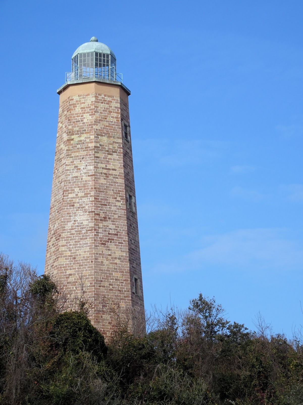
Registered as a National Historic Landmark, the lighthouse was the first construction project authorized by the very first Congress, and cost a total of $17,700. President George Washington personally reviewed bids and selected John McCombs, a NY bricklayer, as contractor. The location at the entrance to the Chesapeake Bay had been strategically important to the British for many years as a trade route and military site, and although there had been talk of constructing a lighthouse on Cape Henry, it wasn’t until 1792 that the project was finally completed. Although damaged in the Civil War, service was eventually restored and continued until 1881 when it was replaced by the modern lighthouse which is still in use today.


Preservation Virginia acquired the Cape Henry Lighthouse in 1930 when Congress deeded them the house and 1.77 acres of surrounding land to preserve it and make it accessible to the public. Over the years the lighthouse and its surroundings have undergone multiple restorations including repairing the lantern after damage from Hurricane Barbara in 1953, repairing the original Aquia sandstone, and restoring the surrounding dunes. The Aquia sandstone that was used in the construction had special significance, as it came from the same Virginia quarries  that provided stone for Mount Vernon, the U.S. Capitol and the White House.


A few facts… The lighthouse has thicker walls at the bottom than at the top, and is octagonal, which makes it strong enough to withstand the elements. When lit, the beacon could be seen 15 miles away; it was fueled by whale oil and later kerosene. The lighthouse weighs about 6,000 tons. When it was originally constructed it was about 500 yards from the shore; today it is only about 250.


Across the street is the New Cape Henry lighthouse, currently undergoing some preservation work. It is also octagonal, and stands 164 feet tall.


So far our Virginia trip had been all about Revolutionary War, but the lighthouse introduced us to the War of 1812. A British naval blockade along much of the US coast had disrupted trade and interfered with commerce, and on February 4, 1813 the blockade was extended to the Chesapeake Bay. To prevent British ships from using it to aid navigation, the light was extinguished. Soon after, the British attacked the lighthouse, and British scouting parties often visited the area for fresh water. On July 14th Capt. Richard Lawson captured 20 British marines nearby.

Commemorating French/British naval engagement

Of course, as the mouth to the Chesapeake, the shores were also the scene of noteworthy events during the Revolutionary War. Here French Navy Admiral de Grasse first engaged the British navy, and when Admiral Graves chose to head back to NY for repairs instead of following De Grasse to the Chesapeake, he left Cornwallis with no option but to surrender at Yorktown.

Admiral de Grasse

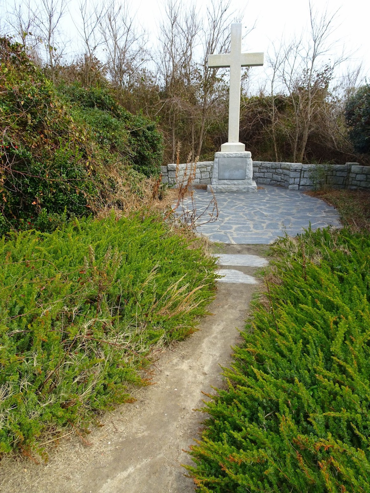
However, Cape Henry’s main significance in history might be as the site of the ‘first landing’. On April 26, 1607 three small ships approached the Chesapeake Bay from the southeast and made their landfall on Cape Henry. The Virginia Company Expedition had set sail from England in December of the previous year, and upon reaching this very spot in what is present day Virginia they planted a cross and named the spot Cape Henry, in honor of the oldest son of King James 1. After a few more days of exploration they anchored at Cape Comfort, moving up the James River until settling at Jamestown on May 13, 1607. In 1935 the Daughters of the American Colonists erected a memorial cross here.


Our visit to Cape Henry luckily came to a close without any more surprises; we were able to visit all the sites in the allotted time and left the military base without further excitement. Now to visit the other ‘First Landing’!

Egg casings of the lightning whelk had washed ashore
To be continued….


Wednesday, February 8, 2017

The Mariners' Museum

It was the town of Newport News that prompted us to join dad on his business trip in the first place. Yes, there were the Petersburg and Richmond Civil War sites, the historic Jamestown and Yorktown, the capitol building and the majestic James River; all sites I had heard of and knew I someday wanted to explore. But it was a museum in Newport News that tipped the scales, because as soon as I mentioned a possible trip to Virginia Lauris declared “I want to see the Monitor!” It didn't take long to convince me - I don't know if it was the influence of my seafaring ancestors or the lure of making history come alive for Lauris, but we penciled the museum in on our travel itinerary. 


The Mariners’ Museum and Park is home to a vast maritime collection; it had just somehow never appeared on my radar. It was Lauris who had started reading history books about the American Civil War, and as he became more fascinated with the Battle of the Hampton Roads, our excitement to visit grew. The naval engagement that occurred at a harbor at the mouth of the James River on March 9, 1862 is remarkable as history’s first duel between ironclad warships and the beginning of a new era of naval warfare. Lauris had researched that portions of the historic ship were on display at the Museum, and so we adjusted our route to Norfolk to allow for time to see history come alive.


We stopped in on the day we visited Yorktown, with the plan to spend a couple of hours exploring – and of course to see the historic Monitor warship. Entrance to the museum is significant, especially if you wish to add the 3D movie to your admission; however even with two exhibits closed for renovation the museum had a wealth of fascinating maritime artifacts on display, and our two hours there passed quickly.

USS Monitor's gun

The USS Monitor was the first ironclad warship commissioned by the Union Navy. Having discovered that the Confederates were building an ironclad warship on the hull of the former steam frigate USS Merrimack (whose iron ‘sides’ were a product of the Tredegar Iron Works we had toured just a few days ago in Richmond), the Union was worried they would lose control of their James River blockade (and eventually Washington DC) to this new warship.  The CSS Virginia had already destroyed the sail frigates USS Cumberland and USS Congress when the Monitor arrived (and just in time to save the steam frigate USS Minnesota!), and after a four-hour battle neither ship was seriously damaged. Eventually the Confederates were forced to destroy the CSS Virginia as they withdrew in early May, after which the Monitor sailed up the James River to support the Union Army during the Peninsula Campaign. While under tow to join blockaders off North Carolina, a storm hit, and on December 31 the ship foundered. Monitor's wreck was discovered in 1973 and has been partially salvaged, with guns, gun turret, engine and other relics on display at the Mariners' Museum. It wasn’t quite the exhibit I had imagined, as all the salvaged parts are underwater in large tanks undergoing active desalination; part of the preservation process is to remove the chloride salts which had accumulated in the turret over 140 years on the sea floor.

NOAA photo on the left, source here, and the lifting device on display at the Museum

Also on display is the claw-like lifting device used by the Navy and NOAA to salvage the turret from the ocean floor, as well as a full scale replica of the turret as salvaged. We viewed the USS Monitor’s red signal lantern, the last object seen by the Monitor’s crew and then later the first artifact recovered from the wreck site. And we traversed the deck of the full-scale USS Monitor, located just outside the museum and connected with two walkways.


Having explored the multiple ironclad/Monitor exhibits we briefly ducked into the new “Polynesian Warriors” exhibition, its displays demonstrating this culture's and community’s focus on the maritime. The boys by this time had mastered “Museum Quest” on the borrowed iPads and were having fun searching for clues. (The interactive scavenger hunt has an app for the iPad, and kids can follow clues to find exciting objects within the museum… if you find all 9 you win a prize!) Our hunt took us out to the courtyard and into the International Small Craft Center.


With more than 150 boats representing 43 countries I was hoping to see a boat from Latvia. Geographically the closest we got was the competition sailboat from Denmark, however I wasn’t disappointed as the variety of boats present (in just one room!) was fascinating. A Venetian Gondola, a "Bull Boat" made from the bison bull, the Agai-ni-awaiau ceremonial canoe... to think how many shapes and materials can all be made to float! Eventually we headed through the courtyard and back into the main building.


The Age of Exploration chronicles the developments in shipbuilding, ocean navigation, and cartography from the 15th through the 18th centuries. Passing through the next exhibit is The Nelson Touch, devoted to Lord Admiral Horatio Nelson of the British Navy. Then Defending the Seas (a history of the Navy) and The Whaleship Charles W. Morgan – the exhibits seemed never-ending! Once we had made our way to the Collections Gallery we hit a dead end as galleries 6 and 9 are closed, but retracing our steps brought us back to the main lobby.


At the center of Museum are some of the most interesting objects. It is here that the Cape Charles Lighthouse Fresnel lens is located, and the eagle figurehead from the USS Lancaster. However Vilis’s favorite portion of the museum is the activity ship, offering the opportunity to explore what life was like aboard a ship on the high seas! The boys played checkers, climbed ladders, tried out the ship’s hammock and marveled over the contents of the trunks; the announcement that the museum would be closing came far too soon.


Once we had left the museum we took a short tour of the 550-acre Park. Open daily, the most popular attraction is possibly the five-mile Noland Trail. However we were quickly losing daylight, so we opted to instead drive the road that circles the Park and the 167-acre Lake Maury. On the far end of the loop is the Lions Bridge, crossing the dam between the lake and James River. Here we stopped to take a closer look at the four lions that stand guard on the parapets, and watched the daylight fade over the water. Tomorrow we would once more be venturing back hundreds of years through history – to the First Landing.


Related Posts Plugin for WordPress, Blogger...