Monday, January 25, 2016

Chattanooga Choo Choo!

With dozens of hotels in and around Chattanooga we found ourselves considering two main options: one would put us close to Lookout Mountain and cut travel time, the other was downtown allowing us to walk to several riverfront attractions. With driving time from downtown to Lookout Mountain, Ruby Falls and Park Point only 15 minutes it didn’t seem to make sense to stay outside the city, and the riverfront options seemed a little pricey… So it came about that we decided on a third option, ideal lodgings for our family – The Historic Chattanooga Choo Choo!


Early Chattanooga was a river and rail town, the first train of Western & Atlantic Railroad arriving in 1849. Southern Railway built a Terminal Station in 1908, the depot serving nearly 50 passenger trains a day in a couple of years. Over the years dignitaries such as Presidents Woodrow Wilson, Theodore Roosevelt and Franklin Roosevelt traveled through the station, but with the advent of other, faster modes of transportation, train traffic slowed to a near halt in the 1960s.


After 60 years of operation, the terminal was closed to the public when the last train stopped on August 11, 1970. Seemingly destined for the same fate as Union Station in the center of town (which was demolished in 1973), the historic building was granted a reprieve. A group of local businessmen invested $4 million dollars to save the building and turn it into a vacation complex, laying the groundwork for the attraction it has become today and ensuring its place on the National Register of Historic Places.

Original tile on the way to the restrooms? Probably!

Architect Don Barber’s creation was a combination of his Beaux Arts Institute prize winning design (1900) and the interior of National Park Bank in NYC. The centerpiece of the station was a dome over the concourse, built of steel and concrete, and buttressed by giant brick arches. Upon its conversion to a hotel the central terminal room was converted into a huge dining hall, the adjacent baggage room becoming a restaurant. A trolley traveled the tracks behind the station, stores opened along formal gardens in the rail concourse, and authentic sleeper cars were converted into furnished sleeping quarters.

...not even midnight and he's hanging from the chandeliers...

The name of the hotel was inspired by a song popularized by Glen Miller in the late 1940s. The first “Choo Choo” train was Cincinnati Southern Railroad’s small wood burning steam locomotive, dubbed the Chattanooga Choo Choo by a newspaper reporter. 


The refurbished engine of the same name on display today is the same kind of wood-burner, and was last used by the Smoky Mountain Railroad in the 1940s.


The Choo Choo complex once again changed hands in 1989, and currently is in the midst of another $8 million renovation. The dome is now a ornate lobby, Christmas decorations still lighting up the hall on our visit. It is impossible to wander through that grand space and not feel the ghosts of past travelers hurrying through on journeys of yesteryear.


Adjacent to the lobby is the Gardens Restaurant where we ate breakfast one morning. Greenhouse-type panels enclose the space during the winter, but we’ll have to return to see if it’s an open-air eatery during the warm months. The dreary morning offered little in terms of sunlight, and so it was happened we didn’t linger long in the formal gardens that day either. Luckily old station platform shelters line the walkways from the hotel rooms to the old station, allowing us dry passage in the rain. 


The following day was ideal for exploration; a formal, Victorian-style garden covers a portion of the old rail lines complete with rose gardens, gazebos, a life-size chess and checkers set and watergardens, home to brightly colored goldfish and water plants of all shapes and sizes.


Surrounding the formal gardens are the sleepercars, Pullman train car “rooms” featuring a queen bed and bathroom. We might go this route on our next visit, as I can imagine the kids would be thrilled to sleep in a train…


Not all the train cars parked on site are sleepers; some are dining cars, the Silver Diner Pizza Car dishing up pizza made fresh to order. From what I gather there will be more on-site dining choices once renovations are complete; however we found more than enough options within easy walking distance during our stay to cover all three meals. My only regret is not having the opportunity to enjoy a drink in the Victorian Lounge, intact with original antique Chattanooga bar and chandeliers.


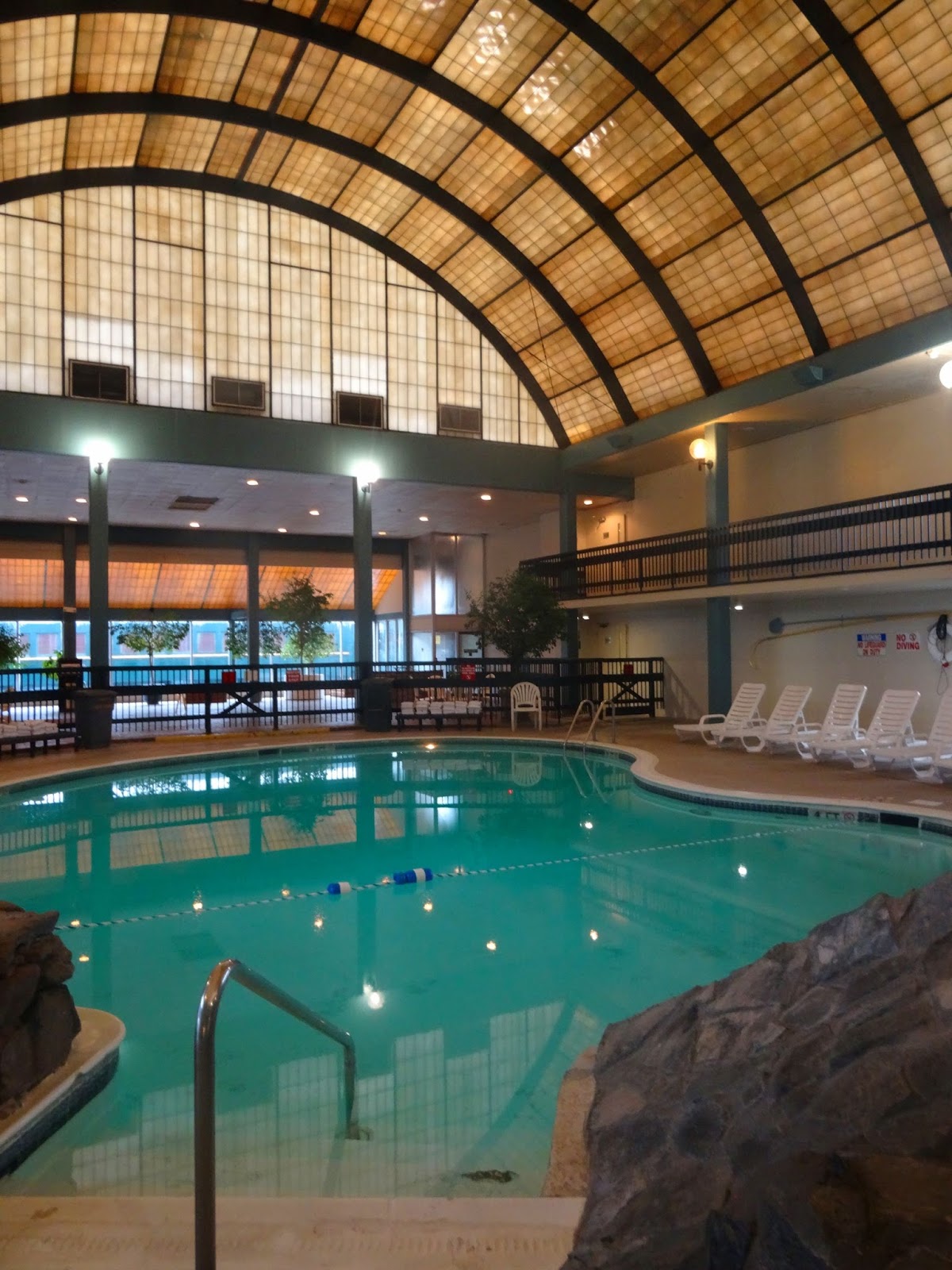
At the far end of the formal gardens is “Hotel 1”, the MacArthur Building, which is named for the last steam-powered freight train to arrive in Chattanooga – it houses hotel rooms and the indoor swimming pool. Although the pool hall renovations have not yet been completed, the pool is open for use and worth bringing your swimming suit for. With a two-story ceiling reminding me of the zeppelin hangars that cover Rīga’s Central Market, I imagined the water would be rather frigid. Instead the enormous pool was heated to a perfect winter temperature, offering the boys a few hours swim time interrupted by bedtime instead of blue lips. I can only imagine what it would look like with the waterfall running down the cliff, especially from the relaxing vantage point of one of the lounge chairs instead of in the water, drink in hand not squirming toddler…

As opposed to a trolley running to take guests from end to end there were golf carts, and although we didn’t take advantage of this amenity I imagine that they could come in handy, especially to get to “Hotel 2” (the Empress Building, “a tribute to the Empress of Blues and Chattanooga-native, Bessie Smith”) and “Building 3.” More hotel rooms, two outdoor pools, hot tub, laundry & fitness and a pet walk area are over at this far end, separated from the terminal by sleeping cars and the completely unfinished space that eventually will have a convention hall. We ran out of time to explore these sections, only ducking into the Depot gift shop and missing the model railroad museum and town hall theatre. On the opposite end of the complex is public parking, and we also didn’t make it over that way – the map shows galleries, an imperial ballroom, a lecture hall and the Centennial Theatre. The parking structure would be a great place to park for those not staying at the hotel, for its proximity to the Station and as a stop for the Chattanooga free shuttle.


The Chattanooga Choo Choo neighborhood is currently in the upswing. With a seemingly abandoned art deco building across the street, our first impression (especially arriving after dark) wasn’t the most positive. However, with the light of day (and after walking to several nearby eateries) our opinion was completely reversed. Only a short distance from downtown, the nearby restaurants are attracting a young and hip clientele. And with the rebirth of Chattanooga as “Gig City” with its (ultra) high-speed internet service, the city will just keep on growing. As an attraction/lodgings/historic landmark all rolled into one the Chattanooga Choo Choo has potential, but whether they will be able to overcome negative pre-renovation reviews and embrace the image of the new Chattanooga, that remains to be seen. I for one sincerely hope the reincarnation of the Choo Choo is successful, and wish the owners luck with the work ahead.


* Check hotels.com for discounted rates from those listed on the Chattanooga Choo Choo website – I feel like we got an excellent deal!

Friday, January 22, 2016

The Barricades

In the popular Bastejkalna parks (Bastion Hill Park) near the Freedom Monument in Rīga, there lie multiple monuments - a testament to the events that unfolded in Latvia 25 years ago. This week in January we remember the Barricades, we honor those who lost their lives, and we remind ourselves that freedom too often comes with the price of human life...

-----------------------------------------------------------------------------------------------

Edijs Riekstiņš, student

Latvia had been forcibly conscripted into the USSR since World War II, when it was Illegally occupied by the Soviet Union. Then, on the fourth of May in 1990, the Supreme Council of the Republic of Latvia declared the restoration of its independence. Pro-Soviet forces tried to provoke violence and seize power in Latvia through a climate of fear and a series of bombings throughout the remainder of the year.

Andris Slapiņš, cameraman

On January 2nd of the New Year, the OMON (Otryad Mobilny Osobogo Naznacheniya, a system of special forces units within the Soviet Ministry of Internal Affairs) seized the national printing house of Latvia and attacked police officers who were documenting the event. Then on January 4th they seized the telephone exchange in Vecmīlgrāvis. Next it was the Ministry of Internal Affairs, and soon Soviet troops and armored vehicles were seen in the streets of the capital. On January 11th of 1991, the Soviet military launched an attack on Latvia's neighbor to the south, Lithuania, killing 13 civilians.

Vladimirs Gomanovičs, senior lieutenant

On January 13th an announcement from the Popular Front was broadcast over Latvian radio, calling for people to gather in Cathedral Square. 700,000 people took to the streets of Rīga, and agricultural and construction machines began arriving to build barricades. Special points of defense including Latvian Television and Radio buildings, as the ability to continue to broadcast in the case of Soviet attack would enable the rest of the world to hear the truth about what was occurring. These barricades were manned 24 hours a day, men, women, students and even families from all over Latvia coming to stand in solidarity against Soviet forces.

Sergejs Konoņenko, senior lieutenant

On January 14th the OMON attacked Brasa and Vecmilgrāvis bridges, then the following night concentrated their efforts on the Rīga branch of the Minsk Militia Academy. The first fatality occurred on January 16th; Roberts Mūrnieks was killed on a second attack on the Vecmilgrāvis bridge. His funeral three days later turned into a demonstration, and on January 20th about 100,000 people gathered in Moscow to show their solidarity and support for the Baltic States.

The two additional casualties were Ilgvars Grieziņš and Gvido Zvaigzne, the fatally injured cameraman (photo source here)

That night OMON and other unidentified combat groups attacked the Latvian Interior Ministry. Two policemen, a student and a cameraman were killed, a second cameraman dying later of injuries sustained in the attacks.


There were further attacks such as the May 23rd OMON attack on five Latvian border posts and the Soviet coup attempt which prompted the Latvian government to declare full independence, but the violence was mostly contained to the January confrontations which have come to be known as the Barikādes. Incidentally Latvia’s independence was recognized by the Soviet Union on September 6th, the Soviet Union then dissolved that December.

Raimonds Salmiņš, killed in the coup attempt in August

Wednesday, January 20, 2016

Chickamauga and Chattanooga

James Walker's "The Battle of Lookout Mountain"

President Lincoln believed that taking Chattanooga was as important as taking Richmond, the capital of the Confederacy. Located on the banks of the Tennessee River at the intersection of four railway lines, power over Chattanooga would cripple Confederate supply lines and possibly win the war. However, after General Rosecrans outmaneuvered General Braxton and his Confederate troops for control of the city, he made the mistake of pursuing retreating soldiers into Georgia where he met intense resistance and suffered heavy casualties in the Battle of Chickamauga, culminating in his abandonment of his troops and being replaced with General Thomas. Nevertheless, the last four months of 1863 and the events that unfolded in Chattanooga have been referred to as “the Death Knell of the Confederacy,” ending with Chattanooga under Union control and transformed into a supply and communications base for General Sherman’s 1864 Atlanta Campaign.


During the Battle of Chickamauga September 18-20, Union troops were forced to retreat into Chattanooga where they remained under siege for one month until General Grant and reinforcements arrived. At the end of November thousands of Union soldiers marched out of the city, overrunning Orchard Knob and setting their sights on Missionary Ridge. To distract the Confederates from their intentions they launched an attack on Lookout Mountain, known as the “Battle Above the Clouds” because of the fog that cloaked the mountain, and the next day Union troops broke through Confederate defenses on Missionary Ridge - forcing the Confederates to retreat south into Georgia.


Chickamauga and Chattanooga National Military Park is the first and largest military park in the US. Dedicated in 1895, it has two main sections covering the Lookout Mountain Battlefield & the Chickamauga Battlefield, and additional, smaller parcels including Moccasin Bend National Archeological District, the Chattanooga National Cemetery and Orchard Knob.


We visited the Chickamauga Battlefield Visitor Center first, exploring the events of September 1863 through exhibits and film. The boys picked up a Junior Ranger booklet and then we headed on the self-guided auto tour, a seven-mile loop including eight major points of interest and dozens of monuments and memorials. We parked near Snodgrass Hill, the site of the Union last stand before retreating to Chattanooga, where we hiked out to the South Carolina Monument.


The following morning we retraced our steps from the previous day’s visit to Ruby Falls, continuing up Lookout Mountain to Point Park, part of Lookout Mountain Battlefield. There is an entrance fee to enter the park, although it is significantly lower than the other Lookout Mountain attractions. We parked next to the Visitor Center and entered through Point Park Gate, built by the US Army Corps of Engineers. Working our way around the East side we marveled at the views of the Tennessee River Valley and Chattanooga.

Point Park's gate is a replica of the Army Corps of Engineers insignia

At the center of the park is the New York Peace Monument, symbolizing reunification and reconciliation with the Union and Confederate soldier shaking hands at the pinnacle (the Monument is emblematically made of Tennessee marble and Massachusetts pink granite).


From the Batteries we continued down the stairs to reach the Ochs Memorials Observatory, where even more spectacular views of the river and Moccasin Bend awaited us. Named for the snake-like curves in the river, the National Archeological District has a 3-mile hiking loop with more services planned. The area has a tragic history; traversed by the Cherokee on their Trail of Tears in 1838, the territory was home to several tribes far before they first encountered the Spanish three centuries ago.


From the Observatory trails depart to Craven’s House and other scenic and historically important points within the National Military Park, but we headed back up towards the Visitor Center. With an extra day or two we might have visited a few of the seven sections on Missionary Ridge set aside to commemorate the battle, but we only had the two days in Chattanooga. I do believe we hit the highlights, and I would suggest a visit to the National Battlefield to anyone visiting the area; between the historical significance of the battlefield, the grandiose views from atop Lookout Mountain and the diverse landscape of the battlefields, there was something for everyone in our group. We left with a new understanding of this portion of the Civil War, an up-close look at one of the most interesting geological formations of the region, and memories of time spent together as a family exploring America’s history. 


Monday, January 18, 2016

See Ruby Falls!

Chattanooga is about a four/five hour drive from Greenville, depending on which route you take; too far for a day trip but close enough for a weekend road trip. I’ve had my eye on the Tennessee city as a possible destination for some time based on feedback from friends who had made the trip, and although I had driven through it many times on my way from Chicago to Georgia (when I lived southeast of Atlanta) I knew very little about this town rapidly gaining popularity among outdoor enthusiasts. With the grandparents in town we decided to head west to the “Scenic City” to see what we could see.


Our first day in Chattanooga was a cold, dreary, rainy January day. The plan was to visit the attractions on Lookout Mountain, but seeing as the only thing that could be seen from the summit were clouds, we opted to stay indoors. Well, sort of.


In 1928, Leo Lambert and a team of excavators found a breathtaking waterfall located 1,120 feet below the surface of Lookout Mountain. They were attempting to drill an entrance to a cave off the Tennessee River that had been sealed when a rail line was built, and instead encountered a previously unexplored opening. Crawling into this chasm the team discovered an underground waterfall, later named after Lambert’s wife, Ruby. Opened as a public attraction in 1930, Ruby Falls draws thousands of visitors each year.


We parked and entered the “Cavern Castle,” constructed entirely of limestone excavated in the 1920’s when installing the elevator. After purchasing our tickets we waited for the next tour to begin, and soon we were assembled near the elevators to start our descent into the heart of the mountain.


From the elevators it is about ½ mile through a narrow, winding path to the falls. Interesting stalagmite and stalactite formations were marked and illuminated, some more interesting than others. It was about 60˚F underground, warm enough that we could leave our winter coats in the car, and the passage was well-illuminated albeit rather uneven, the largest hazards being a stumble or a bump on the head for us taller folk (or the need to use the facilities, as the closest restroom is back on the surface!). Vilis rode in the backpack carrier, a tight squeeze in a few places but still preferable to carrying him on the hip, and the guide was chatty and knowledgeable while a short video emphasized the historical points of the cave. Finally, some 40 minutes later we arrived at the falls.


Ruby Falls is illuminated by a light show which is automatically turned on and off for the various groups. When we arrived it was off, the waterfall audible but not visible. Once the light show started we had about 5 minutes to jockey for position at the railing to take photographs and admire the falls – then the lights went off and the guide started herding us back. In my opinion the ticket prices to this attraction are rather steep, and although I understand that there must be a high overhead for all employees, insurance, lighting etc., I feel that we should have had a little more time at the falls – it was disappointing to feel rushed. The light show also means that you don’t get the view of the waterfall that is shown in the brochure – instead it is fluorescent purples and pinks and blues – also beautiful, but more emphasis placed on the theatrical rather than natural wonder.


Upon emerging aboveground we climbed the tower to see if the weather had cleared. It hadn’t. However, we had a great view of the solar panels that power LED light show. If it wasn’t raining we could have spent some time on the playground, but as it was we headed down the mountain to find lunch. Ruby Falls has snacks for sale, a ziplining adventure, gem mining for kids and various other side attractions, and they offer special events such as lantern tours, holiday lights and even weddings – see website for details.


While there are dozens of caverns and caves in the region, Lookout Mountain is the only one with such a spectacular waterfall. According to the website, it is the tallest and deepest underground waterfall open to the public. In addition to the great views of the Tennessee River valley, Ruby Falls is on the National Register of Historic Places, a rather famous attraction for almost 100 years. However, the passage to the falls was mostly excavated, so although there were some interesting natural formations, the cave itself didn’t compare to other caves we’ve visited (such as the Cave of Antiparos) – it was the waterfall that made this attraction. Finally, if it weren’t for the super-short time at the falls I would recommend this as a must-see in Chattanooga, however based on our experience I instead suggest this as a rainy-day adventure or an excursion offering something different once you’ve exhausted the outdoors options available on Lookout Mountain. 

Friday, January 15, 2016

The Swamp Rabbit - from Falls Park to the Swamp Rabbit Cafe and Grocery

The Swamp Rabbit Trail cuts through Falls Park in the very heart of downtown. If you head south from the waterfall you’ll pass through what soon will be Cancer Survivor’s Park and hit Cleveland Park, the 1.5 mile section I covered in my post The Swamp Rabbit: from the Falls to Cleveland Park. On the other hand if you follow the Reedy River upstream from the falls, you have a 2 mile ride/hike ahead of you to get to a favorite local hangout, the Swamp Rabbit Cafe & Grocery.

The rubber running lane stretches from Reedy View Dr, to Willard

From the waterfall the trail runs north past O-CHA tea bar and Papi’s Tacos, along the RiverPlace Phase 3/Embassy Suites development, to River Street. Currently cars must yield to pedestrians and cyclists on the trail, but it’s a dangerous intersection as despite multiple posted signs, drivers are not always aware they do not have the right-of-way. The City of Greenville has given the green light to the River Street Underpass Project, which will allow for safe passage under River Street for Swamp Rabbit traffic. From there the trail currently runs on Reedy View Drive to the S. Academy St. underpass.

View from Linky Stone Park northwest

At Reedy View Drive and River Street are a couple of two hour parking lots (no limit on nights and weekends) that offer convenient parking for those looking to hop on the trail or visit the small park located under Academy St. The Children’s Garden at Linky Stone Park has deteriorated some in recent years; you might remember the articles in the news last March about the theft of one of the three little bear bronze statues. Other features in the park have seen similar defacement and destruction, with portions of musical instruments removed, flower and herb gardens trampled, and an alarming number of transients present in the area. Despite these glaring differences between Falls and Linky Stone Park, the small park is still an amazing space to explore with children, and with all the development in the neighborhood it is possible that Linky Stone will be restored to its original glory.


Here the Swamp Rabbit Trail makes a sharp turn, heading in a southwest direction under S. Academy before swinging back to the north, still following the Reedy River.  There is some serious development going up on the north side of the river, apartment buildings heralding the growth of downtown to the west. The Swamp Rabbit Trail has helped fuel this advance, as well as the announcements for a new park between A.J. Whittenberg Elementary School and Mayberry Park. But to get to the site of the new park first you must pass through the rather derelict section between Reedy View Drive and Westfield. The foundations of old structures are lost in a tangle of briars and honeysuckle, but although the traffic from Church St. is audible, this is a relatively peaceful stretch of trail.


Once you’ve crossed Westfield you have The Salvation Army Ray & Joan Kroc Center and soccer fields to the left, with a section of land across the river on Martin Street also being part of the Kroc compound – the Kroc Tennis Complex. There are designated flood-plain areas along this section of trail, designed to help manage the large amounts of runoff that enter the Reedy during large rain events. The flooding is a large part of the reason why the Public Works Campus that currently occupies the area of what will be the new City Park has to be moved; hopefully the design of the new park will offer similar flood areas that will absorb some of the storm water, easing the burden of areas downstream. Adjacent to the Kroc Center is A.J. Whittenberg Elementary School.


If you look closely through the tangled underbrush next to the river (or if you’re on the trail in the winter when the foliage isn’t as obstructive) you might notice old rail bridges on the river – a testament to the trail's history as a rail line. These side spurs were historically present up and down the former rail line, connecting the various industrial parks to the main line.

Mayberry Park

Having crossed S. Hudson St. we are now in what will be City Park territory. The public works facility is in various stages of being relocated, some buildings already demolished while others are still in use. This article from greenvilleonline.com gives a good overview of the park plan along with the hurdles and obstacles still to be overcome. Also included within the proposed City Park boundaries is Mayberry Park with a neighborhood baseball field and picnic shelter. These will be on your left just before you get to one of the business that has popped up in recent years, Swamp Rabbit CrossFit - supported partially by proximity to the traffic the trail.


There are grand plans for the property on the opposite side of the Reedy as well. The Swamp Rabbit Marketplace currently in the works will provide new locations for The Community Tap and Due South Coffee, while also featuring a Carolina Triathlon bike store and a Feed & Seed market that will specialize in regional farm products. “The Commons” are being developed from abandoned warehouses at Welbourn Street, and initial plans include green space to extend to the edge of the Reedy River in addition to the marketplace.


After Swamp Rabbit Crossfit there is an easy-to-miss monument to Franklin Delano Roosevelt. Today the rail bridge overhead includes the Amtrak lines that service the Greenville station, but on April 13, 1945 the FDR funeral procession traveling via rail stopped just a short distance from the trail. 15,000 mourners gathered to show their respect to President Roosevelt, and soldiers lined the tracks for a mile north and south of the station. President Roosevelt was in office when he died in Warm Springs, GA, and was buried in Hyde Park, NY.

Looking south with the rail bridge visible in the back

Just beyond the memorial is the Willard St. intersection where the trail makes a sharp jog to cross the river. The next couple of sections have fewer points of interest; to the South is the Reedy while to the north are train tracks. There is almost always a locomotive warming up or cooling down just before the E. Bramlett Rd. crossing, a good point to stop with the boys but also a signal that we’ll soon reach the Republic Locomotive Headquarters. There are more reminders of the rail legacy of the area as well, including an old bridge that used to provide access to the industry across the river; careful, there are no guardrails and a good twenty foot drop to the river and banks below.

A bridge to nowhere

The Bramlett intersection is a bit tricky. With fencing and warning signs for cyclists and motorists alike it has been rendered as safe as possible, but as the trail intersects with train tracks and a road it serves well to be extra aware, especially when crossing with children. East on Bramlett is Legacy Charter Elementary School, the campus not quite visible even in the winter, but traffic increases during school pick-up and drop-off.

The Bramlett intersection

Having crossed W. Washington Street we hit the final stretch. The Parker Sewer & Fire Subdistrict – Administration Fire Station is to the west, and often we’ll pause to watch the firefighters testing equipment; today there wasn’t a fire engine in sight and so we cruised on by, crossing Hampton Avenue and arriving at the Gardening for Good Community Garden. The Swamp Rabbit Teaching Garden is a great opportunity to learn about gardening and meet community gardeners, and the tool lending library is also located on site. During the spring and summer months they usually have weekly volunteer days on which you can join in the fun – check their website for more information.


With the complex near mile 31.5 are several businesses including the Swamp Rabbit Cafe & Grocery (SRC&G). Having been awarded a USDA Local Food Production grant, the grocery is set to expand from the current 2,600 square feet to 6,100 square feet in the near future, adding new local suppliers and creating additional kitchen facilities. While the grant is reflective on the Swamp Rabbit Grocery’s positive influence on the local economy as well as the healthy food on its shelves, the need for expansion in the five years that is has been open on Cedar Lane serves as evidence that the business has coevolved along with the trail and the clientele. I’m excited to see SRC&G grow as they have a community-centered business model; from the ‘Swamp Garden’ playground to the local produce box to the house stecca - we have a dozen reasons to continue to shop at SRC&G and will continue to support them with our business.


Once we had enjoyed a coffee/hot chocolate/pain au chocolate/loaf of stecca and a romp in the Swamp Garden, it was time to don the bike helmets and start our return trip. From Linky Stone Park to SRC&G it is two miles, making the round trip a healthy four-mile ride for the boys on their bikes – a fun winter morning excursion. We topped off the morning with time in the Childen’s Garden at Linky Stone Park, exploring the winter environs until the lure of lunch and football pulled us to the car. Two more miles on the Swamp Rabbit Trail down – 16 more to go!

source: google maps


Related Posts Plugin for WordPress, Blogger...