Friday, August 31, 2018

A superhero party for a pretty super 4 year old


What happens when the still 3-year-old invites some superheroes over to celebrate his fourth birthday?


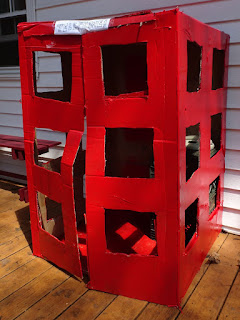
Mom convinces dad that the superheroes need a phone booth on the porch.
8 year old: “Why?”
Mom:  “To change into their superhero costumes of course”
8yo: “But superheroes just go back to their apartments to suit up.”
Mom: “What about Clark Kent? He always used a phone booth.”
6yo: “Mom, what’s a phone booth?”
Mom: …
Dad: 


Mom picks up a bunch of foam pieces and makes a skyline to put in the windows. Because superheroes still have to be able to leap tall buildings in a single bound… I think.


She goes in search of the awesome capes the boys got from their Seattle uncles, and in the process discovers the flippers she spent days searching for before the Lake Jocassee trip - when they fall off the top shelf she is precariously perched under. But she found the capes… and the batman costume that the 6yo will insist on wearing even though it’s about 3 inches too short and gives him a superwedgie… and the batman mask that is still popping up once or twice a day in unexpected places like on the captain underpants that just ran through the house a third time to protest bedtime.


When the superheroes arrive, they get to make their own capes. Because mom totally thought it all thru; it’s not like fabric paint takes 24 hours to dry or anything, of course their creations would be completely dry by the time the kids had to go back to the batcave. And yes, these superheroes make their own capes, it's not like they have The Incredible's Edna Mode at their disposal...

...or do they?

Dad prints out a ton of awesome superhero stuff that we paper the house with. POW! here’s your morning coffee. BAM! oh here’s the peeler, I’ve been looking all over for that. POP! obviously they got another balloon down. SPLAT! someone dropped the glass of milk supermom just poured him.

...and there's the batman mask!

After burgers all the superheroes were given a can of silly string so they could practice their web-shooting in the backyard. BONUS: rolling the spent silly string into balls and decorating each other’s hair with the stuff might have been more fun than the actual silly string shooting… To think I was dreading clean up, but the kids did it themselves!!!


Then dessert and presents. This mom took a shortcut and opted for cupcakes. Deb Perelman has a great, super-versatile batter recipe in her Smitten Kitchen Every Day cookbook, and I added some cute little toppers.


Batman was super-satisfied, and even supermom doesn’t have any regrets – it was a super party. Happy birthday Vili! Now for a supernap…


Wednesday, August 29, 2018

Gulf Islands – Fort Barrancas

Situated on the bluffs overlooking Pensacola Bay, Fort Barrancas was built between 1839 and 1844 with the goal to protect the Bay and the Pensacola Navy Yard. The third fort established on the bay, it was constructed over the ruins of a 1798 Spanish fort named Fort San Carlos de Barrancas. Situated below the barrancas (Spanish for bluffs) was a 1797 water battery named Bateria de San Antonio which was modified to serve as a water battery for the new fort, and connected by a tunnel. To the north was the advanced redoubt, constructed to defend the northern side of the peninsula on which the navy yard was located.


Today, Fort Barrancas is part of the Gulf Islands National Seashore, which stretches 160 miles along the northern coast of the Gulf of Mexico and includes everything from the picturesque white beaches of Florida postcards to maritime forests, bayous, and marine habitat. In the Pensacola Bay area there are multiple parcels that are part of Gulf Islands NS, among others including Naval Live Oaks, and two of the forts that historically fortified the Bay: Fort Pickens and Fort Barrancas. The third Pensacola Bay fort, Fort McRee, is the only one of 42 Third System Forts built between 1816 and 1870 to have completely disappeared. Other Third System Forts include Fort McHenry outside Baltimore, Maryland and Fort Sumter in Charleston, SC.


If you plan on visiting the Fort, be aware that it is located within the Naval Air Station Pensacola, an active military base. All civilian visitors must enter through the West Gate (beware your GPS directions!) and must show proper identification; please see the Park Service website for more details.


After a short stop at the Visitor Center we followed the trail located behind it up a hill. At first all we could see was an American flag, but as we reached the ridge we could suddenly see it all: the fort and water battery, Radford Boulevard winding its way back to the Pensacola Lighthouse, and the blue waters of the bay.


Crossing the drawbridge we entered the main portion of the fort. During the Civil War Forts Barrancas and McRee (as well as the Advanced Redoubt and the navy yard) were occupied by Florida and Alabama militia. The fort was used to organize and train Confederate soldiers, and the cannon were used in a bombardment of Fort Pickens on November 22 & 23 in 1861. When the Confederate army evacuated Pensacola in May of 1862 it was reclaimed by US troops, and the only other action it saw was an attack on the Advanced Redoubt by the Confederate on October 8, 1863.


The boys enjoyed exploring the various rooms and tunnels, and soon we crossed the parade ground to enter the tunnel that leads to the water battery. The battery was originally constructed by the Spanish, who had learned from one of the least known but most significant battles of the American Revolution (when the Spanish took Pensacola from the British) that Royal Navy Redoubt’s position up on the bluff had rendered its fire ineffective. The water redoubt’s design was such that cannon projectiles from the battery would ricochet off the surface of the bay to hit ships at the water line, causing maximum damage. The water battery is the third oldest standing fortification in Florida; only Castillo de San Marcos and Fort Matanzas in St. Augustine are older.


To tour the advanced redoubt visitors have to hike up the ½ mile Trench Trail or drive up to the second parking lot. Fort Barrancas was a powerful defense against a naval attack on the bay, but was exposed to a land attack as the Spanish learned in 1818 when Andrew Jackson was able to plant artillery on a nearby hilltop within range of their fort. Designed to defend against a land assault, the fort was designed to be held by a small body of infantry with a few field guns. By the time construction was finished in 1870, it was already outdated.


Fort Barrancas also quickly became obsolete because of new developments to cannon and naval war vessels, but in 1902 it was equipped with a Fire Commander’s Station to help direct artillery fire from Santa Rosa Island and Perdido Key. The Coast Artillery Corps manned the defenses until World War II, after which Fort Barrancas was declared surplus in 1947. After becoming part of Gulf Islands National Seashore it underwent extensive restoration, which was completed by the National Park Service in 1980.


While at the Naval Air Station Pensacola, make sure to also visit the Pensacola Lighthouse. For more on the Gulf Island National Seashore and area, please see my posts:


Monday, August 27, 2018

Lakeside Trail in the shadow of Table Rock

Despite the cool temperatures the last few mornings, it is still August in the South – summer is (technically) here for four more weeks, and we are taking full advantage of it!


One of the closest state parks to us here in the Upstate is Table Rock State Park, and although the 7.2 mile round-trip hike to the summit of this Upstate landmark beckoned, the August temperatures and humidity nixed that idea. The beach and Carrick Creek swimming hole were full with swimmers, so we hit the trail in search of a little solitude, opting for the 2 mile Lakeside Trail.

Purple-blazed Lakeside Trail

This easy, well-marked trail offers great views of Pinnacle Lake and the mountains in addition to a little bit of history. Just as portions of Paris Mountain StatePark, Table Rock is partially the legacy of the Civil Conservation Corps (CCC). We parked in the lot near the Nature Center, and skirted the swim area to reach the trailhead behind the boathouse. The CCC constructed a portion of the Lakeside Trail in the mid-1930s, and this first portion best showcases the accomplishments of the Depression-era work relief program: a boat landing with stone steps, the Table Rock lodge, and the dam and spillway.


We circled around the East Bay and soon approached Lodge Cove. There is a little up and down in this section, but just enough to make it interesting; I believe that bridges have been proposed to cross the small creeks flowing into the lake, but the boys preferred to rock-hop across, and stopped to look for stones in the cold mountain water. We found plenty of evidence of beavers, and more than one mushroom that required investigating.

The old boat landing on Pinnacle Lake

Soon we reached the old boat landing. Built to allow visitors to paddle from the beach area over to the lodge to have dinner, stone steps allow easy access to the trail and continue up the hillside all the way up to the lodge. The Table Rock lodge is a prime example of CCC construction: fine craftsmanship, locally sourced materials, and much thought given to orientation. It was built with granite and timber taken from local quarries/forests, and the views over the lake to Table Rock are breathtaking. The lodge can be rented for weddings and other gatherings, and the monthly "Music on the Mountain" bluegrass jam sessions brings in musicians and an audience from all over the Upstate.

Table Rock lodge, as seen from Lakeside Trail

It is on this end of the lake that the views to Table Rock open up, and strategically places benches face some of the most scenic vistas. The kids stopped to cast their lines, and we enjoyed watching a great blue heron criss-crossing the lake in search of lunch. Soon after passing the steps that lead up to the lodge, the trail comes to the south end of the lake and Pinnacle Lake dam.


The dam was built to resemble a waterfall, and there is a small parking area offering additional trail access. The trail drops down below the spillway where hikers can get a good view of the water rushing over - Green Creek and Carrick Creek on their way to Lake Oolenoy. A wide spot in the creek where the water slides over a large stone is an inviting swimming hole, although the water is cold, no matter what time of year.

Table Rock peeking over the Pinnacle Lake spillway

Once you cross the bridge, the trail winds around West Cove and turns north. This portion of the trail was completed in 2011 to make the Lakeside trail into a loop, and is more level than the first ¾ mile built by the CCC. Over the 0.8 miles that lead to the picnic shelter parking area we passed one of the cabins and several places to enjoy the view over the lake. We heard the excited shouts of the swimmers long before the beach came into view, and just like that we emerged from the forest. The walk between the two main trail heads is 0.3 miles and passes through the two parking areas and past the playground. If it’s a hot summer day I can suggest taking a swim to cool off as a finale to the hike.

The Table Rock swimming area

Completing a hiking registration card is not necessary to hike Lakeside Trail, however there is an admission fee to this portion of the Park. All the info on boat rentals, swimming, fishing, trails etc. can be found on the SC State Park website, and a YouTube video about Music on the Mountain is worth a watch. We enjoy the cool air coming down the mountain during the summer, but the spring wildflowers and autumn show of color around Table Rock are not to be missed.


* This is a great hike to take visitors to the area who might not want to attempt the long and steep trails to the summits of Table Rock and Pinnacle Mountain; make sure to stop at the Visitor Center across Highway 11 for maps and a quick briefing on the history of the area, and then relax a spell out on the porch while enjoying a spectacular view of Table Rock over Lake Oolenoy. See my guide to the Cherokee Foothills Scenic Highway 11 for plenty of other destinations along the Blue Ridge Escarpment, and this post on how to make the most of one day in the mountains with guests!

Friday, August 24, 2018

Cancer Survivors Park

A huge thanks to Sunshine Cycle for getting me back up and cycling yesterday; after another flat I’ve now got two new tires (better suited to keeping up with the boys) and an upgrade – a kickstand! Sunshine has always been our go-to in Greenville for cycling needs, and their service is A+; I’m no Hincapie, but they get me back on the trail for a reasonable price without making me feel like I need to buy a copy of Bike Repair for Dummies!

Celebration Pavilion

What better way to celebrate being back on two wheels than by hopping on the Swamp Rabbit Trail for a post-school ride before all the autumn after-school activities kick in? We opted to hop on at the brand-new Cancer Survivors Park. Located between Falls Park and Cleveland Park in downtown Greenville, the park had its grand opening on June 1st of this year, and has joined the long list of beautiful parks along the Reedy River watershed.


There are three ways to access the 6.8 acre park: Cleveland Street, Church Street, and the Swamp Rabbit Trail. Despite being so centrally located, it’s a little hard to get to the park by car – there is no access from Church Street or University Ridge. However, the parking lot at 43 Cleveland Street provides free parking, and both Church and Cleveland Street are accessed by ramp, meaning even the 3 year old could easily get to the SRT on his bicycle.

The Chamber Portal

Passing through the gate of blue butterflies, the Celebration of Life Pavilion sculpture dominates the Cleveland Street side of the park. Cancer Survivors Park Alliance is planning to install canvas underneath the metal frame, and hope to illuminate the canvas year round with different colors representing different types of cancer. The metal sculpture sits atop the Survivorship Education Center, utilized for programs and activities to “help people learn more about screening, detection and treatment, as well as how to live beyond cancer.”

A multi-level boulder waterfall next to the Survivorship Center

The park is a result of a partnership between public and private parties, the majority of funding raised through private donations. Not only does it link Falls Park and Cleveland Park, but it is a key piece of the Swamp Rabbit trail, as the 2-foot-wide suspension Spirit Bridge replaced the old ‘cheese grate’ bridge that formerly crossed the Reedy right before it enters Cleveland Park.

Crossing the Reedy River, before and after
While portions of the plan have been completed including a labyrinth, a small amphitheater and the start of the children’s garden, it is obvious that the project has its work cut out for it; kudzu still dominates the steep sides cutting up to Church Street and NEXT Innovation Center, and the black sewage pipes cross the Reedy alongside the beautiful new bridge. However the park is a valuable addition to the Greenville cityscape, not only as the link between the two main parks that are at the center of Greenville's identity, but also for the spiritual aspect; the park has been carefully designed to mirror the various experiences of cancer – high and low points, areas for gathering and for solitude, tranquility, and the journey.

Healing Garden

Cancer Survivors Park is dedicated not only to those who have survived the disease, but also those who are battling it, and the survivors left behind by those lost to cancer. For more information, please visit the Cancer Survivors Park Alliance website.

Fear Not, by Charles Pate, Jr. in the Children's Garden

Source: Cancer Survivors Park website

Tuesday, August 21, 2018

Chihuly Nights at Biltmore

If you haven’t yet been to the Biltmore Estate in Asheville to see the Chihuly exhibit, you have until the first week in October to see this captivating art installation, the first art exhibition in Biltmore’s historic gardens, and the first garden exhibition of Chihuly’s works in North Carolina.

Solo d'Oro (2017)

Electric Yellow and Deep Coral Tower (2017)


Artist Dale Chihuly is an American glass sculptor, famous for his environmental artwork. We have our very own Chihuly piece right here in Falls Park – Rose Crystal Tower – although it is constructed of Polyvitro instead of glass (see my post Chihuly Comes to Greenville).

Pergola Garden Fiori (2018)

Red Reeds (2017)
  
We opted for Chihuly Nights tickets, as they include an evening visit to Biltmore as well as daytime admission the day of your evening visit or the following day to the Gardens, Conservatory, Antler Hill Village & Winery, the shops and the restaurant. The only difference between a day and night ticket really seems to be your entry time into the Biltmore House; an evening tour is self-guided and restricted to the First Floor.

Paintbrush Tower (2014)

Cattails and Copper Birch Reeds (2015) outside the Conservatory

You will want to tour the house, as Laguna Torcello II is located in the Winter Garden. It is the only piece located inside the Biltmore House; Sky Blue and Cobalt Fiori is located just outside the main entrance.

Laguna Torcello II (2018)

Sky Blue and Cobalt Fiori (2017)

Portions of the exhibit can be found along the Pergola, in the Shrub Garden, in the Walled Garden and Italian Garden, and in the Conservatory. The centerpiece, Sole d’Oro, is located on the Esplanade, and two more pieces can be found in Antler Hill Village: Alabaster and Amber Spire Towers & Turquoise and Erbium Fiori.

Sole d'Oro (2017)

The orchids in the Conservator almost showed up the Chihuly chandeliers...

Burnished Amber, Citron, and Teal Chandeliers (2017) - one of two in the Conservatory
  
Our visit was made even more interesting by a summer thunderstorm. Not only did we have the gardens to ourselves, the colors seemed more lush and vibrant. In addition there were some fantastic skies serving as a backdrop to the Châteauesque residence.

We saw the storm coming a long way off

Float Boat (2017) and the Italian Garden
  
If Sole d’Oro is the centerpiece, the sculptures in the Italian Garden are a crescendo – the five works are floating in the ponds, water lilies and koi living among them.

Niijima Floats (2018) and the resident carp among the clouds

Fiori Boat (2017), Neodymium Reeds with Fiori Verdi (2014) in background
It was here that I definitely noticed the Italian influence on Chihuly's work. One of the pieces is titled Palazzo Ducale Tower, and it is the oldest in the exhibition. The initial phase of Chandelier exploration culminated in his Chihuly over Venice project, and the ceilings that could not support chandeliers challenged the artist to create towers. I wrote about Venice, Palazzo Ducale and the Murano glassblowing legacy in my post Venice and Lido, Italy.

Palazzo Ducale Tower (1996) in he Italian Garden is the oldest piece in the exhibition

A visit to Biltmore in the coming months offers the Chihuly experience alongside the landscape architecture of Frederick Law Olmstead; it is no wonder that it has taken nearly two years of preparation to host this exhibit, and it truly is a once-in-a-lifetime adventure that is worth the trip.

Red Reeds (2017)

Sole d'Oro (2017) as seen from the Statue of Diana