We
woke up yesterday morning to rain, the first steady drizzle that we’ve seen in
the Upstate in about three months. The ¼ inch we received from Hurricane Matthew combined with the ¼ inch or so we received yesterday will not be enough
to pull us out of drought, but it might be enough to give some help to the
firefighters trying to contain the wildfire burning up on Table Rock, which yesterday
stood at around 2,000 acres. The residential evacuation order for those living
in the Pinnacle Mountain area has been lifted; containment lines seem to be
holding, although we will know more today as overnight progress is evaluated.
 |
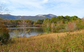
| Table Rock on the day the Pinnacle Mountain Fire broke out |
The
fire started Tuesday, prompting trail closures within Table Rock State Park
including Table Rock Trail. The kids and I had retreated to the mountains on
Election Day for a couple of hikes, and I wasn’t surprised to hear a fire had
broken out; the entire area is tinderbox dry. Although we made a stop at Table
Rock (but luckily nowhere near Pinnacle Mountain!), there wasn’t any smoke
visible and the lack of firefighters makes me think the fire either hadn’t
started or hadn’t been discovered yet. We were actually en route from our second
hike of the day to Pumpkintown Mountain Opry for a late lunch before heading
home. Our first hike had been in Nine Times Preserve where the hardwoods were
bursting with color and the morning air crisp with the promise of cooler
weather to come, but our second hike was chosen more due to proximity (though there was some fall color to be seen).
 |
| On the Natural Bridge Trail |
Keowee-Toxaway State Park is one of the eight South Carolina State Parks located along the Cherokee Foothills Scenic Highway (Hwy. 11) and the edge of the Blue Ridge Escarpment. Known for the views of the Blue Ridge Mountains, the 1,000 acre park is considered a gateway to the Jocassee Gorges. The Park Visitor Center houses exhibits about the region's natural diversity, history and importance as a scientific research destination. If you’re looking to check out the Visitor Center be advised that office hours are 11am to noon and 4-5pm. Despite these rather short hours, the Park is open Saturdays through Thursdays from 9am-6pm and Fridays 9am to 8pm. (And if you’re participating in the Ultimate Outsider program, the stamp can be found on the orientation kiosk at the entrance to the main parking lot so that you don’t have to visit while the Visitor Center is open.)
The
Park is split by Highway 11, with picnic shelters located on a short loop to
the south, and the campgrounds, Visitor Center and hiking trails on the north side. We drove by the rental cabin overlooking Lake Keowee and parked for a few minutes to take
in the view. The ½ mile trail that departs from the campground emerges from the
woods nearby, allowing guests to reach the Lake to fish and recreate. Returning
to the Visitor Center we parked and packed up for the Natural Bridge Trail
loop.
A lollipop
loop, the trail takes visitors over a natural rock bridge and through the
foothills of the Blue Ridge Mountains. At the far end of the loop is the Raven
Rock trailhead, that combined with the Natural Bridge loop provide for a
4.4-mile hike past rock outcrops, views of Lake Keowee, and Raven Rock.
Meanwhile Natural Bridge Trial makes for a 1.3-mile hike, with views of the
natural rock formation and several small waterfalls on Poe Creek.
We
elected to hike the loop clockwise, starting off with the more strenuous
section along the creek. Several up-and-downs took us past numerous small
waterfalls, the first of which was off a spur trail to the left. Soon we came
to Keowee Falls, meriting a second stop to explore.
After
rock-hopping across the creek we reached yet another small spur trail, this
time to the right just opposite the Raven Rock trail. This would have been a
perfect place to stop for a picnic had we brought one!
Then,
rather abruptly we reached the natural rock bridge. The trail crosses it, the
exposed rock and drop-off on either side the give-away that you’re standing
over the creek. We took our time exploring the bridge area, climbing giant
rocks, peering under overhangs, and playing peek-a-boo under the bridge.
The
remainder of the trail parallels the road, the sounds of traffic replacing that
of rushing water on the first half of the hike. With fewer places to stop and
explore we made good time on the way back, and soon enough closed the loop
before finally emerging in the parking lot.
This
is a really nice spring hike, as the wildflowers, mountain laurel and rhododendron
are blooming. Or a summer hike, when the hot temperatures
allow for splashing in Poe Creek. Autumn and winter have their benefits (most
significantly empty spots in the small parking lots, and less traffic on the
trail), but if it wasn’t for hiking in Nine Times Preserve that morning, we
probably would have headed to Table Rock instead. As it was, it was fortuitous
that we ended up where we did, even though by the time the Pinnacle Mountain fire
posed any danger to visitors the trails had been closed. Keeping my fingers crossed
for more rain – it isn’t just the firefighters that need it.
*
Please see my previous post on the Pinnacle Mountain Fire. Historically the
Southern Appalachians burn in times of drought, and although wildfire can be
alarming when threatening lives and property, the fire is mostly burning on
State Park lands and will have positive impacts on our forests.


No comments:
Post a Comment