Wednesday, April 18, 2018

The Black Lagoon and Wakulla Springs

Billed ‘strange and mysterious waters,’ a 6,000-acre sanctuary is hidden away in a quiet corner of the Florida panhandle, 30 minutes from Tallahassee and more than an hour from St. George Island. However the unique cinematic history as well as its incredible geographic features convinced us to make the trip to Wakulla Springs State Park, and we were so entranced that we are already making plans to return!

The deepest part of the spring is just beyond the buoy

The heart of the park is Wakulla springs, one of the largest and deepest in the world. The freshwater springs are a result of the unique geology created by the prehistoric seas that once covered the area; when the seas retreated they left behind sandy soils over limestone, and when water eats away at the limestone, holes develop. The result is called ‘karst,’ and the holes and tunnels (resembling Swiss cheese) are linked in an enormous underground cave system that serves as the aquifer for the region. The freshwater springs are 185 feet deep with a flow rate of 250 million gallons of water per day.


Several underwater scenes for the 1954 horror movie “Creature from the Black Lagoon” were filmed in Wakulla Springs, as well as Tarzan movies from the 1930s, “Return of the Creature,” “Night Moves” and “Airport 77.” The clear water of the deep spring along with the tropical vegetation growing along the Wakulla River (and the alligators that go with it!) make for ideal filming conditions. If you take the boat tour your guide might point out some of the spots utilized most frequently in filming.

One of the River Tour boats making the rounds

One of the boys’ favorite portions of our visit was the boat tour. When the water is clear enough, the Park offers glass-bottom boat tours over the spring itself, however on our visit rainfall (with higher nitrogen levels) and the invasive & exotic species of hydrilla and algae had teamed up to create a dark water day; on these days visibility in the basin is too low to permit the glass-bottom boats to operate. However, the 3-mile River Tour operates 365 days a year (with exceptions for extreme weather) taking visitors up the river among the giant bald cypress trees to see alligators, native birds, turtles and other wildlife up close. The morning of our visit dozens of alligators were taking advantage of the warm day to sun themselves on the banks, and a manatee was seen on its way out to the coast to feed; the gentle giants cruise the waters in the summer, and a pod has been known to winter around the springs where the water stays a constant 70° year round.

See it?

The tour guide was very knowledgeable on the flora and fauna of the park, but also the historical aspects. Archaeologists have uncovered giant Mastodon bones and evidence of inhabitants dating back more than 14,000 years in the area! A complete mastodon skeleton recovered from the spring is on display at the Museum of Florida History in Tallahassee.

Clockwise from left: white ibis, hooded mergansers, male anhinga (during breeding season flesh around the eyes turns bright emerald green), double -crested cormorants and the common gallinule

The river boat tour presented an opportunity to get up-close views (and identification) of wading birds, anhingas, grebes, ducks, and many others.  A number of species breed and raise their young in the waters of Wakulla River, and migratory species travel through from fall through spring. For boat tour pricing please see the Wakulla Springs website.

A cooter sunning itself among the cypress knees

It isn’t necessary to take the boat tour to see the spring, however. The deepest spot is adjacent to the swimming area, and a dive tower allows for viewing the spring and a two-story perch to plunge into the cool waters. The historic tower used to be four stories; I will admit jumping off the bottom level provided enough excitement for us, and swimming/jumping is at your own risk – no lifeguards are present. Also, swimming and snorkeling are limited to this designated swimming area (alligators!), and although scuba diving is allowed at some designated sinkhole areas, the Wakulla Springs are off limits.

Then and now. Historic photo source here

Another way to see the park is on the 9 miles of trail, either on foot, bicycle or horseback. The Nature Trail leads through southern hardwood and maple-cypress forests, with several state and national champion trees along the way. The entrance to the Cherokee Sink trailhead is on Hwy 61 two miles south of Hwy 267, and leads 1.4 miles to an 80 foot deep sinkhole lake. On the Riversinks Tract of the park visitors can hike the Bob Rose Trail, which follows the cave system and showcases karst features such as dry and wet sinks, swallets, and collapsed caves. On our visit we stopped at Sally Ward Spring, the reason why the area is called Wakulla SpringS, not spring; the second, 18ft deep spring is located near the park entrance and flows into the Wakulla River just downstream of its sister spring.


Placards throughout the park describe the biological, historical and other features that make Wakulla Springs so unique. It was shortly after Edward Ball purchased the property in 1931 that the Historic Wakulla Springs Lodge was built, and period furnishings include a grand piano, marble checker tables, a massive fireplace and the lodges only TV. The Spanish-Moorish style mansion (Mediterranean Revival architecture) is two stories with 27 rooms, lavished with pink and grey marble (including one of the world’s longest marble counters in the gift shop), and cypress beans and ornate hand painted ceilings grace the grand reception room. Upon Ball’s death in 1981 the property went to the State of Florida, and today the Lodge is listed on the National Register of Historic Places and is designated as a National Natural Landmark. Even if you’re not staying/dining in the lodge, plan to stop in, if only to see “Old Joe,” the 11’2” stuffed alligator that was a longtime resident of Wakulla Springs before it was illegally killed in 1966.


Visitors should definitely plan on spending the whole day at Wakulla. We utilized picnic tables for lunch, swam for several hours, toured the grounds, took the boat tour and still had multiple things we wanted to do before we left. In the immediate vicinity of the Park you’ll find other points of interest as well, including state capital Tallahassee, St. Mark’s Wildlife Refuge and the St. Mark’s Lighthouse (on the Forgotten Coast Lighthouse driving tour), the world’s smallest police station in Carrabelle (plus stop here for coffee!), and the National Forest. That evening our route would take us to a favorite spot for Apalachicola Bay oysters back on St. George Island, and the next day we would be on our way west through Apalachicola and St. Joe, to Panama City Beach.


Monday, April 16, 2018

St. George Island on the Florida panhandle

St. George is a 22-mile barrier island on the Gulf Coast, just south of Apalachicola. Connected to the mainland by a 4 mile bridge, the island is less crowded than some of the other Florida panhandle barrier islands, but every bit as beautiful, with its stunning beaches and clear blue water. My last visit to the area was over 10 years ago during a family reunion; we vacationed on Cape San Blas (on the opposite side of the point from St. George Island) and explored St. Vincent and St. Marks National Wildlife Refuges, as well as the St. Joseph peninsula. My memories of the beaches are of white sands and clear, sparkling water with the nearby marshes & unique scrub forests offering unique wildlife viewing, while the towns of Apalachicola and Port St. Joe featured mouthwatering seafood and laid-back Florida hospitality without the crowds of the western FL shoreline.

St. George Island Lighthouse

The bridge to St. George crosses Apalachicola Bay straight to the middle of the island, the Cape St. George Light cheerfully greeting visitors from the Gulf shore. This central portion is where the majority of restaurants and a couple of hotels are located. The scenery and atmosphere were as I expected; despite being spring break season, the crowds and traffic were nowhere near the level of the Pensacola and Panama City area beaches.

Easter eggs, beach-style

The southern ¼ of the island is a part of the St. George Plantation, a private recreational community that has multiple vacation homes for rent. We spent Easter with family and friends, emerging to the beach for shelling and swimming forays, and to hunt sand crabs with flashlight by the light of the full moon. We often saw dolphins headed along the shore, and great blue herons stalked the coast in search of a meal.

Boys + flashlights + nighttime = adventure

The north 1/3 of the island is St. George Island State Park, one of a dozen Florida state parks along the panhandle coastline. Nine miles of pristine beach with majestic dunes, bay forest, sandy coves and salt marshes await exploration. The main drive only takes you halfway into the park; the remainder is accessed by bicycle or on foot on a series of hiking trails, boardwalks and the beach. Pack a lunch and take advantage of one of the multiple picnic pavilions. Not only can you cook up burgers on one of the grills, but the pavilions offer a rest from boogie boarding & shelling, and shade from the midday sun.

Great blue heron

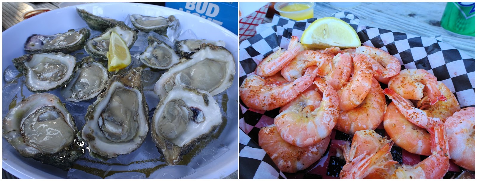
Canoeing and kayaking are favorite activities in the shallow Apalachicola Bay, but my preferred form of recreation to experience the bay on this trip was eating. Apalachicola Bay oysters represent 90% of Florida’s oyster harvest and are renowned for their size and taste. Apalachicola is the last place in the US where, by law, wild oysters are still harvested by tongs from small boats. The brackish waters in the bay that allow the local wildlife (including oysters) to thrive are a result of the rivers that empty into the bay: the Chattahoochee flows along the Alabama-Georgia state line, the Flint River and the Ochlockonee River runs through Georgia, and Apalachicola River in Florida (which is actually the Flint and Chattahoochee together). Together they drain a watershed of over 20,000 square miles, but over the last decade the growing water shortage in the Atlanta metro area led to additional water diverted from the Chattahoochee; the result was a three-state legal fight over water rights and the tragic decline of oysters in the Bay. Although the populations are slowly recovering, the delicate balance of fresh water and saltwater in the Bay is surely to be an issue in the future as the Southeast’s thirst for water grows. (For a more in-depth read about the Apalachicola Bay oysters, here’s an article on Eater)

Raw oysters and shrimp at Paddy's Raw Bar

If sunning, beach-combing, swimming, fishing and birding aren’t enough to keep you occupied on St. George, there are multiple nearby destinations to keep you busy for weeks.
  • I highly recommend a stop at the Apalachicola National Estuarine Research Reserve on the mainland just across the bridge in Eastpoint (which I’ll be writing a separate post about in the near future): 90 acres on the Sound, complete with wonderful exhibits in the Nature Center, ½ mile of boardwalks, and Millender Park with picnic pavilions and beach access.
  • The Cape St. George Lighthouse is one of four lighthouses on Florida’s Forgotten Coast Lighthouse Driving Tour. 
  • St. Marks and St. Vincent Wildlife Refuges offer wildlife viewing opportunities and educational programming. 
  • The nearby towns of Apalachicola and Carrabelle have their own unique charm and offerings. Tate’s Hell State Forest and Apalachicola National Forest have hiking, camping, fishing, horse & ATV trails. 
  • A little further is Wakulla Springs State Park, famous from movies such as Tarzan and Creature of the Black Lagoon, but a Panhandle gem with its spring-fed lake, historic Lodge and ranger-led riverboat tours.


However you just might be content in settling in with a good book while the kids spend their time in the surf and sand. Whatever floats your boat, St. George seemingly has it all; I’m sure we’ll not allow another 10 years to pass before our next visit to the area.


Friday, April 13, 2018

The dunes of Jockey's Ridge

The wind coming off the Atlantic Ocean has played a primary role in the history of the Outer Banks. It provided the Wright Brothers with needed lift at the Kill Devil Hills site of first flight, yet it also blows in hurricanes and storms so powerful that some theorize might have been a factor in the disappearance of English Colony on nearby Roanoke Island. Whether this is fact or fiction, what we do know is that the barrier islands have been shaped – physically and historically – by these winds, and nowhere is this more evident than at Jockey’s Ridge State Park.


Jockey's Ridge is the tallest active sand dune system in the Eastern United States, the shifting winds constantly reshaping the dunes. Nags Head Woods and Jockey's Ridge were designated a National Natural Landmark in 1974 by the National Park Service. Today, the park is a favorite spot for flying kites, sandboarding (with permit), hang-gliding (through vendor) and watching sunsets, and the trails and visitor center provide insight into the history and ecology of this unique region.


You’ll want to start your visit at the visitor center & museum. After exploring the exhibits and picking up maps, take some water and sunscreen and head out onto the dunes on the 360ft boardwalk. From a viewing platform you can get a good perspective of the expansive sands of the park’s 420 acres before heading off into the dunes.


Jockey's Ridge encompasses three distinct ecological environments: dunes, maritime thicket, and the Roanoke Sound estuary. We explored the dunes first, and although for every two steps you take up the dune it’s one step back, don’t let that discourage you from climbing to the top of the biggest dune. There you’ll have a view of sand, surf, and sea - from the Sound all the way to the ocean. The park’s dunes consist of three peaks, and due to the constantly shifting sand, plants and animals do not live there. Around the base of the dunes you’ll find grasses and plants, providing habitat for small animals and insects. Don’t forget to bring shoes (the sand gets hot!), sunscreen, your sunglasses, water bottles, and a kite!


For a closer look at Roanoke Sound head out on the 1.5 mile Tracks in the Sand trail. The trail starts off with a short section through a forest of shrubs. The maritime thicket grows best in areas protected by the dune, which provides protection from wind and salt blown off the ocean. The live oaks, persimmons, red cedar, wax myrtle, bayberry, sweet gum, red oaks and pines are stunted by the effects of the wind and salt, causing them to look like shrubs. Fox, deer and raccoons live in the thickets, but you’re more likely to spot birds and a variety of insects.


The trail crosses a wide section of dune before reentering the forest, and eventually loops for a section along Roanoke Sound. At the shoreline, there is an area of restored marsh where nesting ospreys visit during the summer months, and the views of the dunes and sound are magnificent no matter the season. The trail is a Kids in Parks TRACK Trail, and brochures are available at the trailhead or inside the visitor center. A section of the North Carolina Mountains-to-sea trail is also located within the park.


The Sound-side of the park offers a completely different experience: sunbathing, wading, paddling and the 1-mile Soundside Nature Trail that tours the wetlands, grassy dunes and maritime thickets of the southern corner of the park. The Roanoke Sound Estuary is a rich habitat for a variety of plant, animal and bird life; the sound provides nesting areas for waterfowl, serves as a fish nursery, and is home to the blue crab. Windsurfers and kiteboarders are a common sight, and the sun setting over the sound often brings a crowd.

Events such as this lights on kites festival are a regular occurrance at the park

Legend says the park was named as a result of the early inhabitant’s practice of capturing wild ponies and racing them on the flat surface at the base of the dune, while the steep sides of the ridge served as a grandstand of sorts for spectators. Horses are no longer free to run on this portion of the Outer Banks - you’ll have to head north of Corolla to see the remaining population of wild Spanish mustangs. However, there’s still plenty of motion to be seen from a perch on the ridge: the dunes endlessly shifting, boats on the water, kites in the air… Jockey’s Ridge truly is alive, and a must-see for visitors on the Outer Banks.

Wednesday, April 11, 2018

The peak of spring ephemerals and a waterfall


Invited to view wildflowers on a Conserving Carolina property on the North Pacolet River, I didn’t hesitate – I convinced a few friends to join us, and we headed north a few days later, knowing that there was only a narrow window to catch the peak bloom of the spring ephemerals. I knew we were in for a treat when we started seeing trillium from the car window as we slowly wound along the North Pacolet, and the notion was confirmed upon parking at the small trailhead – enormous trillium among Solomon’s Seal literally just outside the car door.

Jack-in-the-pulpit, Arisaema triphyllum

Sweet white trillium, Trillium simile

Formerly the Pacolet Area Conservancy, Conserving Carolina owns and protects several parcels of land between US176 and decommissioned railroad tracks along the North Pacolet River. A trail was installed to discourage visitors from utilizing those tracks to access a waterfall on a side creek, and that trail has also opened a one-of-a-kind property to those seeking the ultimate spring wildflower experience.

Sessile bellwort, Uvularia sessilifolia

Wild ginger, Asarum canadense

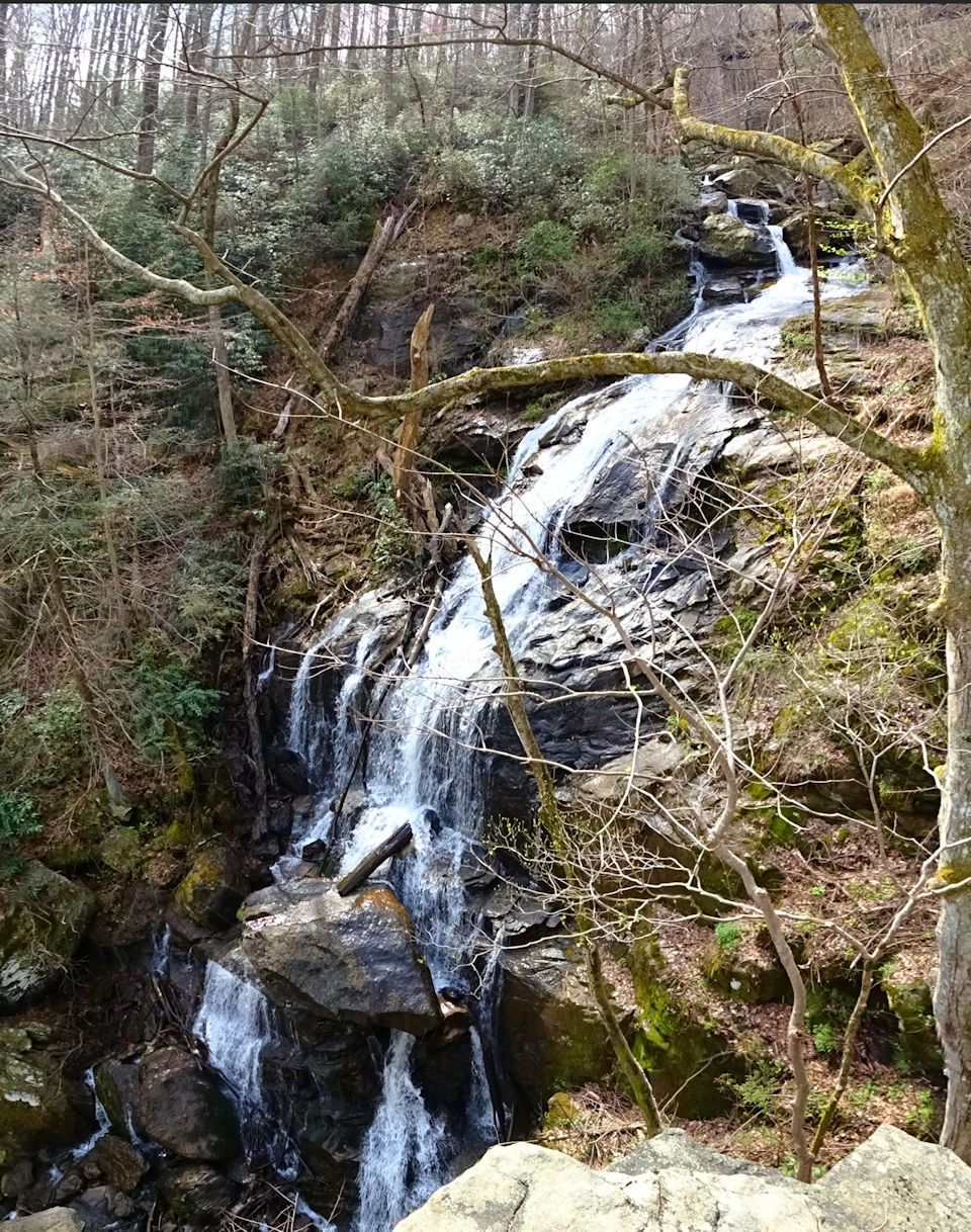
The trail was promoted to me as “the best place for spring ephemerals in the region,” and it didn’t disappoint – this was the most incredible wildflower experience I have ever had. Our progress was incredibly slow as we stopped to look at every new flower we found, and although this tempo considerably added to the total hike time, it also distracted us from the terrain. Though not a difficult hike, there is enough change in elevation to rate this trail moderate. However, the trail ends at a rocky overlook to a 60ft waterfall, and the trail at this end is steep and dangerous. Just last week a local man fell 70 feet at this point, sustaining severe injuries; please know that a slip or moment’s inattention can end in disaster, and use common sense and more than a grain of caution. 


The trail also crosses two small tributaries, both homes to multiple species of salamanders. The streams can be crossed by rock hopping, or getting your feet a little wet – possibly both, if you’re a three year old.


Branch lettuce, Micranthes micranthidifolia

There are also two unofficial trails head down to Big Fall Creek, however both are heavily eroded in steeper sections. The second of the two provides a safer method of access to the bottom of the waterfall (than climbing down from the top), although the falls themselves aren’t completely visible. And finally, closest to the trailhead there is a spur trail that leads past rock outcrops to the railroad tracks.

Dutchman's Breeches, Dicentra cucullaria

Yellow mandarin, Disporum maculatum

In addition to the hazardous cliffs area of this hike, there is also a high concentration of poison ivy; even this early in the year we found vines and budding leaves that could transmit their poisonous oils.

White baneberry, Actaea pachypoda


So, sum total: moderate terrain, creek crossings, dangerous drops, poison ivy, plus the usual hazards (ticks, chiggers, snakes etc.) = the most incredible spring ephemerals in our area… Choose your own adventure!

*****

In addition to the wildflowers pictured above, we also saw: violets, Solomon's Seal, toadshade (Trillium cuneatum), trout lily (Erythronium americanum), mayapple (Podophyllum peltatum), bloodroot (Sanguinaria canadensis), wild bleeding heart (Dicentra eximia) and another dozen that I'm not confident enough to identify...

Monday, April 9, 2018

History Comes Alive at Andrew Jackson State Park

Andrew Jackson State Park is so close to the NC border that it took a visit to Charlotte to get us there the first time. However, this educational destination is really just a little over two hours from Greenville, entertaining both the possibility of a one-day road trip, or a weekend tour if combined with a night at the campground. Jackson was the only U.S. president native to South Carolina, and he was born near the Upcountry, in Lancaster County.


View of the schoolhouse through the historic orchard

Be sure to start your Park tour at the Andrew Jackson Museum, where you’ll find Revolutionary War artifacts and relics related to the Park’s namesake and his presidency. Jackson was the 7th President, elected in 1828 and remembered for winning the Battle of New Orleans against the British in the War of 1812. Through exhibits that portray life in the SC Carolina backcountry during the late 18th century, visitors can explore the impact of the Revolutionary War on the local communities and imagine what Jackson’s childhood was like. Watch a short movie, pick up a park map, and then head out to tour the rest of the park. (Museum hours are 1-5pm/weekends, or by appointment Monday through Friday)

In the museum...

Coming out from the Museum you’ll see the statue Boy of the Waxhaws. Noted American sculptress Anna Hyatt Huntington was the recipient of a letter campaign started in 1962 by the Lancaster County schoolchildren, asking for a statue honoring Andrew Jackson on the 200th anniversary of his birth. A gift to the children of South Carolina, the piece was finished when Huntington was 90 years old. Children from elementary schools throughout the state donated money to provide the base, and together with the statue weighs 25,000 pounds; the granite base bent the crane when it was being installed.

Huntington's Boy of the Waxhaws

“I have Jackson as a young man of sixteen or seventeen seated bareback on a farm horse, one hand leaning back on the horse's rump and looking off over his native hills, to wonder what the future holds for him.” –A. Huntington 

Side note... Horses figure prominently in Anna’s work; you’ll find another equine-themed piece (titled Fighting Stallions, 1950) at the entrance of Brookgreen Gardens in Murrells Inlet, the largest outdoor sculpture garden in the world. Brookgreen Gardens were established by the artist, and the winter home of Anna H. Huntington and her husband Archer Milton Huntington was just across the road; the couple donated this land to found another of South Carolina’s State Parks, Huntington Beach State Park. In the old Moorish castle Atalaya that is located within the park is a big chamber which functioned as her sculpting studio; it was complete with cages and chains to contain live animals such as horses & bears for study while she sculpted.

Beautifully aged picnic shelter


Originally ‘Waxhaws’ was the name given to an Indian tribe that lived in the area, while later it referred to the region of the Carolinas that included the counties of Chester, Lancaster & York along the Catawba River, and the western edge of Union County in NC.

On the steps of the schoolhouse

Also near the Museum are multiple sites of historic interest. Andrew Jackson State Park’s Historic Orchard and Herb Garden features fruit trees and herbs that were sources of food, flavorings, dyes and medicines in the Carolina Backcountry during the late 18th century. An 18th-century replica schoolhouse is open for lessons mid-March to November, 1-5pm Saturdays and 2-5pm Sundays. And next to the schoolhouse is a Carolina Fence Garden, which incorporates natural and cultural elements that have been designated symbols of our state.


In addition, the 360-acre State Park contains a large lake. It is open to fishing with a SC fishing license; try your luck from the banks of the 18-acre lake, from the fishing pier, or rent a boat. You can bring your own boat, however gasoline motors are not allowed on the lake – see park website for more information. Swimming is not permitted.


On the list of must-do things at the Park is the 1-mile loop trail that circles the lake, Garden of the Waxhaws Trail. On a recent visit the redbuds and trout lilies were blooming, and we observed various migratory birds and other wildlife while on our hike. Another trail, the Crawford Trail, takes visitors on a 1-mile loop through the mixed oak, cedar and pine forest behind the Meeting House.

Trout lily and rue anemone on the Garden of the Waxhaws trail

A unique way to experience the park is during one of their annual events. Every year in March there is a birthday celebration (this year was Andrew Jackson's 251st birthday) with traditional artisans, militia demonstrations, museum tours and colonial games for the kids. In fall, visit to view the endangered Schwientz's Sunflower in bloom. Then in November join costumed volunteers for the annual ‘Life in the Waxhaws Lantern Tour’ with storytelling, demonstrations and a 30-minute lantern tour of the park.


A playground, amphitheater, campground and picnic facilities, as well as the living history programs are numerous additional reasons to visit this intriguing midlands State Park. To round out your Andrew Jackson itinerary, visit the Old Waxhaw Presbyterian Church cemetery five miles to the southwest of the park; this is the church that Andrew Jackson attended, and his father and two of his brothers are buried there. Or continue on to Landsford Canal State Park, where visitors can view the well-preserved remains of a canal system to bypass shoals on the Catawba River. Whatever your motivation in visiting this corner of the state may be, know that a stop at Andrew Jackson State Park will offer a fascinating glimpse into the life and times of our 7th President, as well as showcase the natural beauty of the midlands of our state.

Related Posts Plugin for WordPress, Blogger...